CRUISERS NET
Cruisers Helping Cruisers
Comprehensive cruising resource for the Intracoastal Waterways
from Norfolk to the Northern Gulf and Bahamas.
from Norfolk to the Northern Gulf and Bahamas.
FREE to use due to the generosity of our sponsors - please patronize them
Celebrate Spring with Gray’s Reef National Marine Sanctuary, Savannah, GA
Gray’s Reef National Marine Sanctuary protects Georgia’s special live-bottom wildlife habitat in the Atlantic Ocean and along the southeastern U.S. coast, an area teeming with diversity and an abundance of marine life.
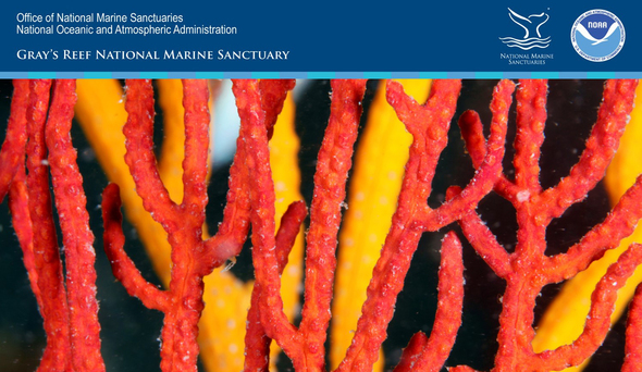
These sea fans at Gray’s Reef are animals classified as cnidaria (naɪˈdɛəriə), a family containing over 11,000 aquatic species found mainly in our ocean. Photo credit: Greg McFall/GRNMS

Calling all Captains!
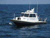
Skidaway Institute of Oceanography, a unit of the University of Georgia, seeks applications to fill an immediate need for a Captain / Marine Operations Coordinator with NOAA/Gray’s Reef National Marine Sanctuary.
This position serves as Master of the R/V Joe Ferguson, a 41 ft research vessel, and the R/V Sam Gray, a 36 ft research vessel operated by Gray’s Reef National Marine Sanctuary. In coordination with the Vessel Operations Coordinator (VOC), ensures effective vessel operation and safety of ship and crew personnel to successfully complete science cruise missions. This is a full time position with time/effort split between cruises (<120 days per year with average duration of 10hrs) and shore duties. For more information on the duties and responsibilities, training and experience, and how to apply click here

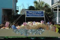
Savannah St. Patrick’s Day Parade
Be on the lookout for the Gray’s Reef National Marine Sanctuary float during the Savannah St. Patrick’s Day Parade on Saturday, March 16. We will bring the reef to the street and showcase the treasures of the sea during the “Hostess City” of the south’s 195th heritage parade. Take pictures of the Gray’s Reef float and share them with us at #graysreef
Gray’s Reef National Marine Sanctuary
graysreef.noaa.gov
1 Facebook Likes, 1 Facebook Reactions
Be the first to comment!
GA Coastal Resource Division Begins Annual Angler Survey
During this survey, CRD staff goes to boat ramps, marinas, shorelines and other places along Georgia’s 100-mile coastline and asks anglers to participate in a survey that collects data later used to help keep our saltwater fisheries healthy and robust.

Click here for CRD: Annual angler survey kicks off
Be the first to comment!
FWC: Boating Education in Florida
The National Association of State Boating Law Administrators and the Florida Fish and Wildlife Conservation Commission (FWC) encourage all boaters to take a boating safety course.

Click here for Gain an edge on the water and keep it with boating education – ‘Spring Aboard’ with FWC
Be the first to comment!
Historic public lands legislation signed into law!
Boating United has long been a strong advocate for waterway conservation and boaters’ rights. Kudos!
 Today, President Trump signed the Natural Resources Management Act into law – a big win for the recreational boating and fishing community. Thank you to everyone who helped get this important legislation across the finish line.
This law permanently reauthorizes the Land and Water Conservation Fund, promotes conservation, provides greater local control of water management, and protects and expands access to public lands and waters for boating and angling.
NMMA and our outdoor recreation coalition partners applaud this landmark, bipartisan legislation, and we will continue to work towards bolstering conservation and access to our nation’s lands and waters, so we can enjoy all forms of outdoor recreation for generations to come!
Best,
Nicole
PS: If you haven’t already, check out our 2019 policy agenda by clicking the following link:https://www.nmma.org/advocacy/issues/policy-brochure Boating United is the grassroots platform of the recreational boating industry. It is comprised of boating manufacturers, businesses and supporters who share the common goal of protecting and promoting the industry. Take action, learn about the issues and more at http://boatingunited.com/Be the first to comment!
Spring Commissioning, Charleston City Boatyard, Wando River, Charleston, SC
The Charleston City Boatyard, a subsidiary of Charleston City Marina, A CRUISERS NET SPONSOR, is found on the northern reaches of the Wando River north of red marker #40. Also see Free Bottom Paint Offer.

Spring is just around the corner!
Good morning Charleston City Boatyard customers,
Don’t wait till Spring is upon us to update your Canvas!
Is your canvas damaged or faded?
Have your enclosure windows become hazy or stiff?Now is the time for an update before boating season arrives!
Charleston City Boatyards Canvas Shop can help you with your canvas needs!Canvas Shop @ City Boatyard
Is your canvas damaged or faded?
Have your enclosure windows become hazy or stiff?
Now is the time for an update before boating season arrives!
Canvas Shop @ City Boatyard can help you with your canvas needs.The City Boatyard’s onsite Canvas Shop can design and install your next canvas package. We use the most durable products for long-lasting top-quality results. Let us repair or replace your:
• Cockpit & Bridge Enclosures
• T-tops
• Bimini Tops
• Clear Curtains / Isinglass
• Sail Covers
• Mooring & Storage Covers
• Dodgers
• Upholstery & Cushions
• Frameworks & Hardware
• and more…Contact (843) 884-3000 or dschellie@shmarinas.com
for a quote today. 

Upcoming Events  Charleston In-Water BoatshowDon’t miss out on Charleston’s only In-Water boatshow!Date: March 29-31
Location: Brittlebank Park & Bristol Marina
Learn More Warmest Regards,
Ron Gift | General Manager
CHARLESTON CITY BOATYARDBoatyard Office Hours :
Monday – Friday | 7:30 a.m. – 5:00 p.m.
Copyright © 2019 Charleston City Boatyard, All rights reserved.
Thank you for being a valued customer of Safe Harbor Marinas!Our mailing address is:Charleston City Boatyard
130 Wando Creek LnCharleston, SC 29492
Click Here To Open A Chart View Window, Zoomed To the Location of Charleston City Boatyard
Click Here To Open A Chart View Window, Zoomed To the Location of Charleston City Marina
Be the first to comment!
Gateway to the Gulf Newsletter from the City of Gulfport, Fl, March 11 2019, Boca Ciega Bay

Gulfport Municipal Marina, A CRUISERS NET SPONSOR, and the City of Gulfport always have a full calendar of events for all ages. The marina and harbor, found on the northern shores of Boca Ciega Bay, are easily accessible from the Western Florida ICW, just north of Tampa Bay.

Click Here To Open A Chart View Window Zoomed To the Location of Gulfport Municipal Marina
Click Here To Open A Chart View Window Zoomed To the Location of Gulfport Anchorage/Mooring Field
2 Facebook Likes, 2 Facebook Reactions
Be the first to comment!
FOCUS ON Palm Coast Marina, FL AICW Statute Mile 803
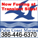
Palm Coast Marina, one of our newest CRUISERS NET SPONSORS, is located just west of the Intracoastal Waterway at Statute Mile 803 between St. Augustine and Daytona Beach.

We are located just off the Intracoastal Waterway Mile Marker 803. Latitude 29* 34.6 N Longitude 81* 11.58 W We monitor channel 16 and our working channel is 69.
www.PalmCoastMarina.net
386-446-6370One of Florida’s newest cities (officially incorporated 1999), Palm Coast is a Florida paradise – situated on 70 miles of saltwater and freshwater canals and the Intracoastal Waterway and just minutes from pristine Atlantic Ocean beaches. Vibrant lifestyle and the natural environment go hand-in-hand here. The City offers a dozen beautiful parks, 125+ miles of connecting trails and paths for walking/bicycling, abundant fishing and boating, a year-round Running Series, and world-class tennis and golf. Lined with historic oaks, towering pines and indigenous vegetation, Palm Coast’s parks and trails showcase the splendid elegance of the native Florida landscape. Bird-watching is popular at St. Joe Walkway and Linear Park, which are designated as Great Florida Birding & Wildlife Trails, and visitors can spot dolphins and seabirds as they stroll along the Intracoastal.For your convenience, our marina is open for business 7 days a week, from 7:00am until 5:00pm.
So, next time you’re on the East Coast, cruise in and experience our peaceful surroundings, frequent wildlife sightings, convenient location, & professional staff and see for yourself why Palm Coast Marina has been the destination of genuine cruisers for over
32 YEARS!
The Palm Coast Marina, located at the mouth of the Palm Coast saltwater canal system, has 80 slips, a ship’s store, and a brand-new fueling station. Mobile repair services and detailing are available, and there is even on-site kayak rentals and yacht brokerage!  Volume fuel discounts are available! We are the only fuel stop between
St. Augustine and Daytona Beach. We offer private showers, on-site laundry, and even a boater’s lounge!Palm Coast, located in Flagler County, is an oceanfront community with a hometown feeling that respects and protects the natural environment – where the sun shines abundantly and people love to get outdoors year-round for fresh air, exercise and family fun! Living in a healthy environment is important to us. Since our early days, Palm Coast has been carefully designed for a healthy balance between nature and development. We value trees, waterways and beautiful, natural landscaping that give our community a “wow” factor. You’ll find native Florida foliage and colorful birds and wildlife along magnificent trails, along with pristine beaches, world-class golf and tennis and plentiful boating and fishing.
We are conveniently located less than 40 minutes from Daytona Beach International Airport and approximately 1.5 hours from the Orlando International Airport. Ocean access can be had from St. Augustine (approx. 25 miles north) and Ponce Inlet (approx. 40 miles south). Access can also be made from Matanzas’s Inlet (approx. 10-15 miles north of Palm Coast) depending on boat size and tidal conditions.

St. Augustine Inlet 
Ponce Inlet 
Matanzas Inlet 
Our marina is conveniently located within walking distance to multiple restaurants, bars, shopping, parks and even the Palm Coast Community Center, which offers (often free!) classes and events for children, teens, and adults.
The European Village is a ten minute walk from the marina and is a one stop-destination for all things dining, lounging, shopping, and entertainment – featuring 6 restaurants, 6 shops, 5 bars, and 2 cafes! Also, you don’t want to miss your chance to stock up on fresh produce, breads, tea, honey and more at their weekly Farmer’s Market.


Linear Park, located less than two miles from the marina, is a 57-acre property featuring many amenities for all to enjoy, including a playground, picnic pavilions, hiking and biking trails, shuffleboard, bocce ball and bird watching. The park has been designated as a Great Florida Birding Trail by the Audubon Society for its vast diversity of bird species numbering at times over 40.
Care to play a round of golf? Palm Harbor Golf Club is located a short 1.2 miles away and offers a full service practice facility with a driving range, putting green, & chipping green complete with newly renovated bunker. The pro shop carries both men’s and women’s name brand apparel and equipment.
Other nearby amenities include:
ATM/Bank: offsite; 2.50 miles Post Office: offsite; 2.50 miles FedEx / UPS: offsite; 2.50 miles Dry Cleaner: offsite; 2.50 miles Grocery: offsite; 2.50 miles Restaurant: offsite; 0.25 miles Shopping: offsite; 2.50 miles Liquor store: offsite; 2.50 miles Pharmacy: offsite; 2.50 miles Marine Store: onsite Hardware: offsite; 3.00 miles Motel: offsite; 0.10 miles Airport: offsite; 30.00 miles Car Rental: offsite; 3.00 miles Hospital: offsite; 1.00 miles Doctor: offsite; 2.50 miles Dentist: offsite; 2.50 miles Veterinarian: offsite; 2.50 miles Beach: offsite; 3.50 miles Fitness Center: offsite; 2.50 miles Golf: offsite; 1.00 miles 
Our dock services include: - A brand new FULL SERVICE FUEL STATION WITH Valv-Tect DIESEL & Valv-Tect NON-ETHANOL GAS, fuel available at transient slips for added convenience
- Pump Out
- After Hours Docking Assistance
- Trash pick-up and disposal
- Dock Carts
- Professional, on-site Marine Mechanics and Boat Detailing

For your communication needs, we provide: - Free High-Speed Wi-Fi
- On-site General Mailbox
- Mail Pick-up
- Mail & Package Hold
- Phone Messages
- Fax
- Fedex & UPS

Palm Coast Marina is proud to be recognized as a Clean Marina by the Florida Department of Environmental Protection! Copyright © 2019 Palm Coast Marina, All rights reserved. Click Here To Open A Chart View Window, Zoomed To the Location of Palm Coast Marina
2 Facebook Likes, 2 Facebook Reactions
Be the first to comment!
CCCC 2019 Cruise to Pink Shell Beach Resort and Marina, Matanzas Pass, Gulf Coast
The Cape Coral Cruise Club is a group of dedicated cruisers who always provide unique reports from the marinas they visit. Pink Shell Beach Resort and Marina, A CRUISERS NET SPONSOR and voted Best Small Marina in 2017, overlooks the westerly banks of the Matanzas Pass channel, west of marker #13. Pink Shell Beach Marina is a favorite of the CCCC, see https://cruisersnet.net/174459
CAPE CORAL CRUISE CLUB
CRUISES TO PINK SHELL MARINA
By Captain John Queen, Past Commodore, Cape Coral Cruise Club
Each month, the Cape Coral Cruise Club takes a scheduled cruise to a different marina in SW Florida and stays there for several days enjoying the amenities and hospitality of that area. We do that nine times a year along with an extended cruise each Spring and take a break during the summer months of July and August. For February 2019, our destination of choice was Pink Shell Marina at Fort Myers Beach.
Pink Shell has always been a popular destination for the club and this cruise was no exception. We had 17 boats arrive on Tuesday, February 19th and it was nice to see the long path of yellow club burgees flying on the bow of each boat. Our club burgee sports our club mascot – a dolphin holding a drink of some sort (an adult beverage, I would surmise). After safely docking Tuesday, club members convened in the late afternoon for cocktails, snacks and conversation.
We fired up the marina’s grill around 5:00 and cooked up hamburgers and hot dogs, and along with a slew of side dishes prepared by club members, had a wonderful feast on the marina lawn.
After dinner, club members met in the Mariner’s room at the resort for a competitive little game I called the “Bagel Finagle”. Each year, when my wife Pati and I host the club’s cruise to Pink Shell, I’ve created some kind of crazy game for members to play we and provide prizes for 1st, 2nd and 3rd places. The object of this game was to transfer 3 bagels from one end of the room to their waiting spouse at the other end of the room, and then walk back and deposit into a bucket. Easy enough, eh…? Not by my rules!
The first bagel had to be placed on the forehead, and without touching it, walked across the room and back. The second bagel was a little trickier where a straw was used to transport the bagel. The third round was the most difficult. In that trip, a spouse had to carry the bagel on their forehead across the room to their waiting spouse and then sandwich the bagel between their foreheads and shuttle back to the waiting bucket. It was a hoot watching everyone do the ‘bangle dance’ with a bagel stuck between their heads!
Wednesday morning, we provided breakfast for all club members consisting of scrambled eggs, sausage links, fresh fruits and pastries.
After breakfast, club members met at the marina lawn at 10:00 for second game – a scavenger hunt! The scavenger hunt consisted of 10 questions where all the answers can be found on the property of the Pink Shell Resort and Marina. Many of the questions consisted of simple math. For example, one question was “Dusseldorf plus Chicago minus the number of planks on the marina gangway”. The marina sports a pole sign with distances in miles to various destinations. So this question was fairly easy, until club members were forced to manually count all 120 planks on the marina ramp! The Marina sports a sign post with distances from it, in miles, to various destinations. This question was quite easy, until Club members realized they had to manually count the 120 planks on the pier access gangway.
The rest of Wednesday found many club members relaxing in the pool, walking the beach, or shopping downtown Fort Myers Beach at Times Square. Wednesday evening, we all took the open-air tram to Nervous Nellie’s for dinner. We had about 35 members in attendance and the restaurant provided us with a private area to dine. The winners of the scavenger hunt were announced and everyone had a good time.
Thursday morning was another round of prepared breakfast with eggs, sausage, fruits and fresh bagels (not recycled!) Club members spent the rest of the day enjoying Pink Shell amenities, visiting with friends, and just plain ol’ relaxing. Thursday night, everyone headed off to dinner on their own. My wife and I joined another couple for dinner at the new Coste restaurant at the Diamondhead Resort on Fort Myers Beach. My salmon served on a cedar plank was absolutely scrumptious!
Fortunately, Mother Nature was quite cooperative during the time we stayed at Pink Shell, and we were truly blessed with lots of sunshine.
On Friday morning, we slipped lines and headed home. Much appreciation goes to Dave and Craig, the dock masters at Pink Shell Resort and Marina, for their hospitality and special accommodation to the Cape Coral Cruise Club for making our trip a wonderful event to remember.
The Cape Coral Cruise Club is open to new members who own a boat with overnight accommodations and reside in the Cape Coral / Ft. Myers area. For membership information please contact Phil Kryger at 239-541-0236. Read additional Club information on its website, www.ourgrouponline.com/CapeCoralCruiseClub

Member boats at Pink Shell floating docks

Docktails on the closed in lawn area

Full moon over the Pink Shell Marquee
Click Here To Open A Chart View Window, Zoomed To the Location of Pink Shell Beach Resort and Marina
Be the first to comment!
Albemarle Sound Marina Festivals, April 26-June 9, Albemarle Sound, NC


Albemarle Loop
Whether you are traveling north or south, the rivers and communities that frame the Albemarle Sound are inviting you to explore their shores and experience their warm southern hospitality. A community of marine businesses and historical locations, located on and around the Albemarle Sound of North Carolina, have organized to serve boaters through the Albemarle Loop. For more see FOCUS ON Albemarle Loop. Our thanks to Sam Giovinazzi for this invitation to Albemarle Sound Marina Festivals!
The 2019 Albemarle Loop cruisers program will include the Albemarle Sound Marina Festivals, April 26-June 9, 2019. For information, see Life on the Loop www.albemarleloop.com and www.facebook.com/AlbemarleLoop. These web sites are the GOTO locations for the Events Calendar. Thirteen marinas are grouped together promoting Food, Arts, Fairs, Festivals, Waterfront Communities around Albemarle Sound. If you are interested in adding a www.albemarleloop.com link to your web site contact me at Felix “Sam” Giovinazzi, sam.giovinazzi@gmail.com, 858 414 8727.
Participating marinas:
Albemarle Plantation**
Edenton Harbor**
The 51 House at Wharf Landing
Columbia Municipal Marina
Hertford Bay Marina
The Pelican Marina
Yacht Doc@ Cypress Cove
Elizabeth City Mariners Wharf**
Plymouth Landing Marina
Alligator River Marina
Dismal Swamp Visitors Center**
Shallowbag Bay Marina
Waterside Marina Downtown Norfolk
** CRUISERS NET SPONSORS
Best regards,
Looking forward to working with you
Sam Giovinazzi
Marketing and Sales Director
Albemarle Loop1 Facebook Likes, 1 Facebook Reactions
Be the first to comment!


Social Media Auto Publish Powered By : XYZScripts.com
Comments from Cruisers (1)
They have their own GPS.
Good shot Win!
Paul (Bens room mate 🙂