CRUISERS NET
Cruisers Helping Cruisers
Comprehensive cruising resource for the Intracoastal Waterways
from Norfolk to the Northern Gulf and Bahamas.
from Norfolk to the Northern Gulf and Bahamas.
FREE to use due to the generosity of our sponsors - please patronize them
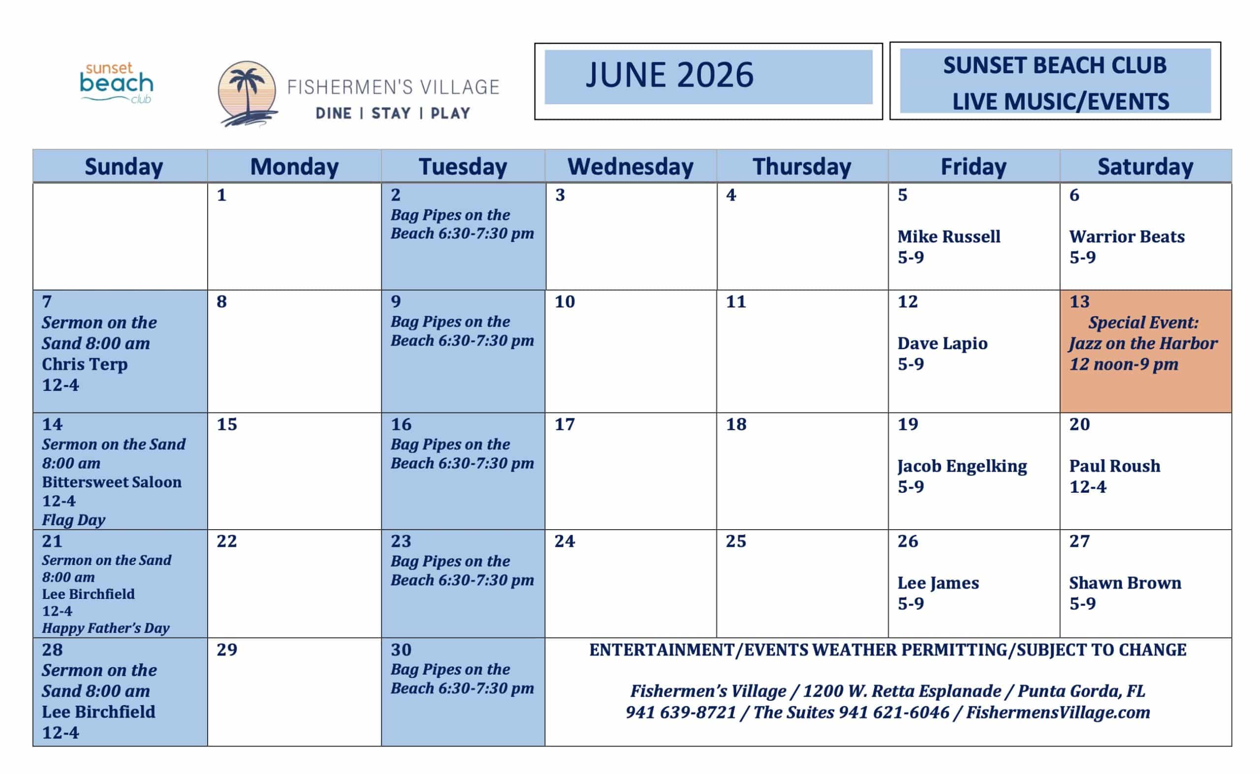
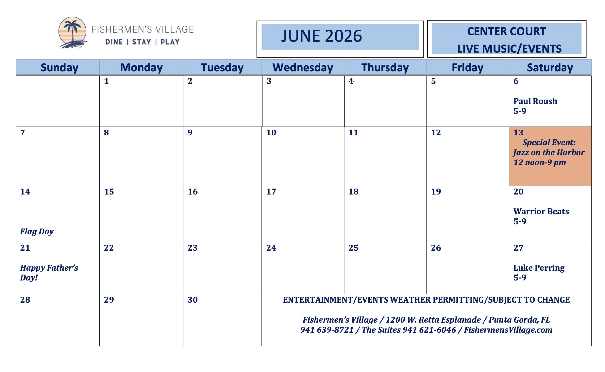
Fishermen’s Village June 2026 Calendars, Punta Gorda, FL

There is always plenty to do around Charlotte Harbor. While berthed at Fishermen’s Village Marina, A CRUISERS NET SPONSOR, you are certain to enjoy visiting Western Florida’s beautiful Charlotte Harbor/Peace River.
Fishermen’s Village JUNE Calendars of Entertainment/Events
June 2026 Sunset Beach Club Calendar
June 2026 Fisherman’s Village Calendar

Special Events & Community Relations941.639.8721
Click Here To View the Western Florida Cruisers Net Marina Directory Listing For Fishermen’s Village
Click Here To Open A Chart View Window Zoomed To the Location of Fishermen’s Village
Be the first to comment!
Don’t get complacent with tropical outlook; ‘it only takes one’ – CoastalReview
Be the first to comment!
The Three “P’s” of Marine Fire Safety – Chubb
https://www.chubb.com/ca-en/individuals-families/resources/the-three-ps-of-marine-fire-safety.html
The three “P’s” of marine fire safety
When spending time with friends and family on your boat or yacht, everyone’s enjoyment and safety should be your top priorities. As the frequency of recreational marine fire-related accidents has increased, so have the injuries and deaths associated with them. To keep yourself, your family, and your friends safe while aboard your boat or yacht, it’s important to abide by safe boating practices, particularly fire safety, so you can enjoy your time on the water and make it back to the dock safely for your next adventure.
Below, we’ve outlined the three “P’s” of marine fire safety every boater should follow.
Prepare
- Understand how to fuel up safely. Be sure the engine blower is operational and on before fueling and restarting the engine.
- Develop a plan and practice what you’ll do if you need to extinguish a fire or abandon ship.
- Know who to call for help and what to say, depending on the situation.
- Make sure you know how to safely use a galley stove or barbeque grill on board.
Prevent
- Install smoke and CO detectors in the cabin and other enclosed compartments.
- Install automatic fire suppression system in the engine room. This might also save you money on your insurance premiums – contact your broker for details.
- Inspect the wiring on battery terminals and breaker panels on high-amperage circuits. If necessary, obtain an electrical inspection or survey.
Protect
- Not all fire extinguishers are alike or should be used for every fire. Make sure you purchase the correct quantity and type of fire extinguishers as required by Transport Canada and have them inspected at least every two years by a local fire department or civil authority.
- Purchase fire blankets and mount them in the galley so they are readily available if needed.
- Create an evacuation plan in the event your vessel needs to be moved from a fiery area.
Be the first to comment!
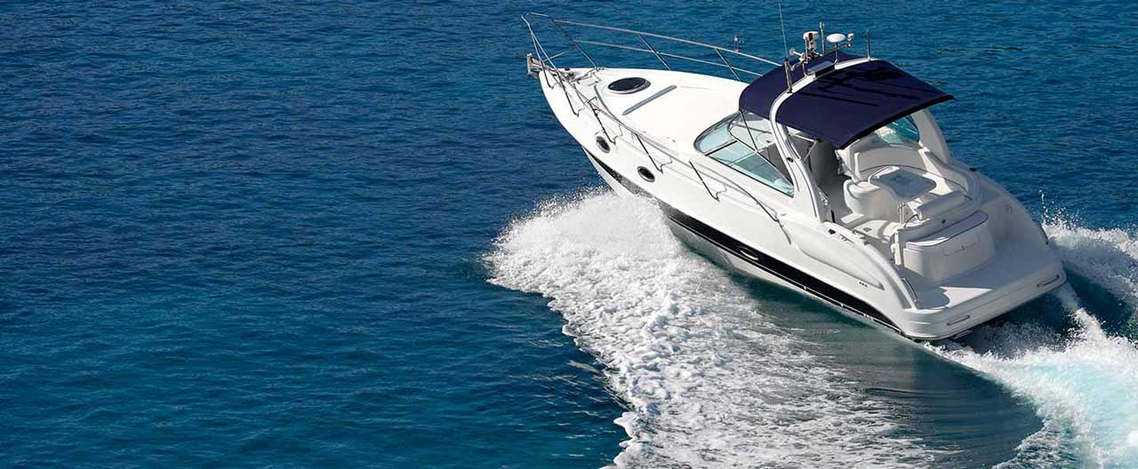
How To Dock a Boat In 4 Simple Steps – BoatUS

BoatUS is the leading advocate for boating safety in the US and A CRUISERS NET SPONSOR.
BoatUS Magazine’s Mike Vatalaro teaches you to how to bring your outboard- or sterndrive-powered boat alongside a dock or bulkhead in four simple steps. Learning how to dock a boat, particularly to come alongside a bulkhead or approaching the gas dock, doesn’t have to be difficult. We’ll docking a boat down to four simple steps to help ensure your success. Go out and practice docking your own boat, and it should become easy. Read more at https://www.boatus.com/expert-advice/…
Docking didn’t go so well? See our gelcoat repair for vertical surfaces video:
 • Boat Gelcoat Repair On Vertical Surface [M… or how to repair a scuffed rub rail: • Keep Your Boat’s Vinyl Rub Rail Looking Ne… 🚩
Enjoy this video? Become a BoatUS Member today to get 25+ valuable benefits including a subscription to award-winning BoatUS Magazine! https://boat.us/e/sy-join 🚩Visit the BoatUS Magazine website: https://www.boatus.com/Expert-Advice. Read more about coming alongside a dock at https://www.boatus.com/expert-advice/…
BoatUS is the nation’s largest association of recreational boaters with more than half a million Members. We provide a diverse offering of services including marine insurance, on-the-water towing provided by TowBoatUS, the nation’s largest fleet, plus boat financing, graphics and lettering, representation for boaters on Capitol Hill, the award-winning BoatUS Magazine and much more. For more than 50 years, BoatUS has made boating safer, more affordable and more accessible. 🚩Download the BoatUS App today to access NOAA marine weather, tides, exclusive Member discounts, and your BoatUS account. Assistance on the water has never been easier with TowBoatUS CONNECT in the BoatUS App — the fastest way to get a tow! https://boat.us/sy-app
Be the first to comment!
Cruisers’ Net Weekly Newsletter – May 22, 2026
Cruisers’ Net Newsletter for this week has just been emailed via Constant Contact.
If you want to view the newsletter but are not signed up to receive them automatically, you can view it at https://conta.cc/43noaup or see it below.
To automatically receive our emailed Fri Weekly Newsletter and Wed Fuel Report, click:Be the first to comment!
SCDNR to conduct courtesy boat inspections during Memorial Day Weekend – SCDNR

SCDNR to conduct courtesy boat inspections during Memorial Day Weekend
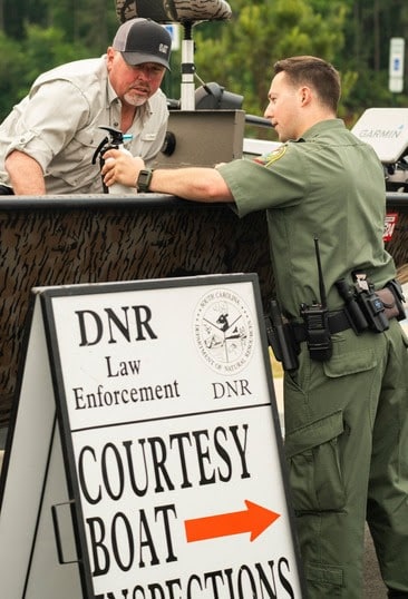
SCDNR officers will perform quick but thorough inspections for required safety equipment at public boat landings during the Memorial Day weekend. (SCDNR photo)
In an effort to keep people and waterways safe during the Memorial Day Weekend, the South Carolina Department of Natural Resources (SCDNR) Law Enforcement Division will be conducting courtesy boat inspections at public boat landings around the state. The Memorial Day holiday kicks off the summer boating season and is one of the busiest times of the year for South Carolina lakes and waterways, and officers want to do everything possible to keep everyone’s weekend fun and safe.
SCDNR boating safety and enforcement officers will perform quick but thorough inspections for required safety equipment and proper boat and motor registrations. Those who are not in compliance with safety regulations or registration requirements will not be ticketed during the complimentary inspections. Instead, they will be given an opportunity to correct the problem before they launch their boat. SCDNR officers will also be available to answer questions and give boaters tips on how to stay safe on the water.
To report boating violations such as reckless operation or an intoxicated boat operator, call the SCDNR toll-free, 24-hour hotline at 1-800-922-5431 or dial #DNR on your cellular phone.
For a copy of South Carolina’s boating regulations, to find out about local boating safety courses, or to obtain a free float plan form, contact the SCDNR boating safety office at 1-800-277-4301 or visit http://www.dnr.sc.gov/
education/boated.html. Memorial Day Weekend boat inspection locations:
Saturday, May 23:
- Anderson County: Twin Lakes Landing, Lake Hartwell, 9AM-11AM
- Charleston County: Wapoo Cut Landing, Intracoastal Waterway (ICW), 9AM-11AM
- Greenwood County: SC Highway 72 Landing at Break on the Lake, Lake Greenwood, 9AM-11AM
- Horry County: Little River Landing, 9AM-11AM
- Lexington County: Lake Murray Dam Landing, 9AM-11AM
- York County: Ebenezer Park/Lake Wylie, 9AM-11AM
- Beaufort County: Battery Creek Boat Landing, 9AM-11AM
Sunday, May 24:
- Beaufort County: Lemon Island Boat Ramp, 9AM-11AM
- Charleston County: Remley’s Point, 9AM-11AM
- Clarendon County: Alex Harvin Landing, Lake Marion, 9AM-11AM
- Colleton County: Bennett’s Point Landing, 9AM-11AM
- Kershaw County: Clearwater Cove Landing, Lake Wateree, 9AM-11AM
- McCormick County: Dorn Landing, Lake Thurmond, 9AM-11AM
- Berkeley County: Amos Gourdine/Russellville Landing, 9AM-11AM
Monday, May 25:
- Charleston County: Limehouse Landing, 9AM-11AM
- Georgetown County: Carroll Ashmore Campbell Marine Complex Landing, 9AM-11AM
- Lexington County: Lake Murray Dam, 9AM-11AM
- Pickens County: South Cove Landing, Lake Keowee, 9AM-11AM
- York County: Ebenezer Park/Lake Wylie, 9AM-11AM
Cheyenne Twilley
Chief of Education, Outreach, and Information
South Carolina Department of Natural Resources
260 D Epting Ln, West Columbia, SC 29172
Be the first to comment!
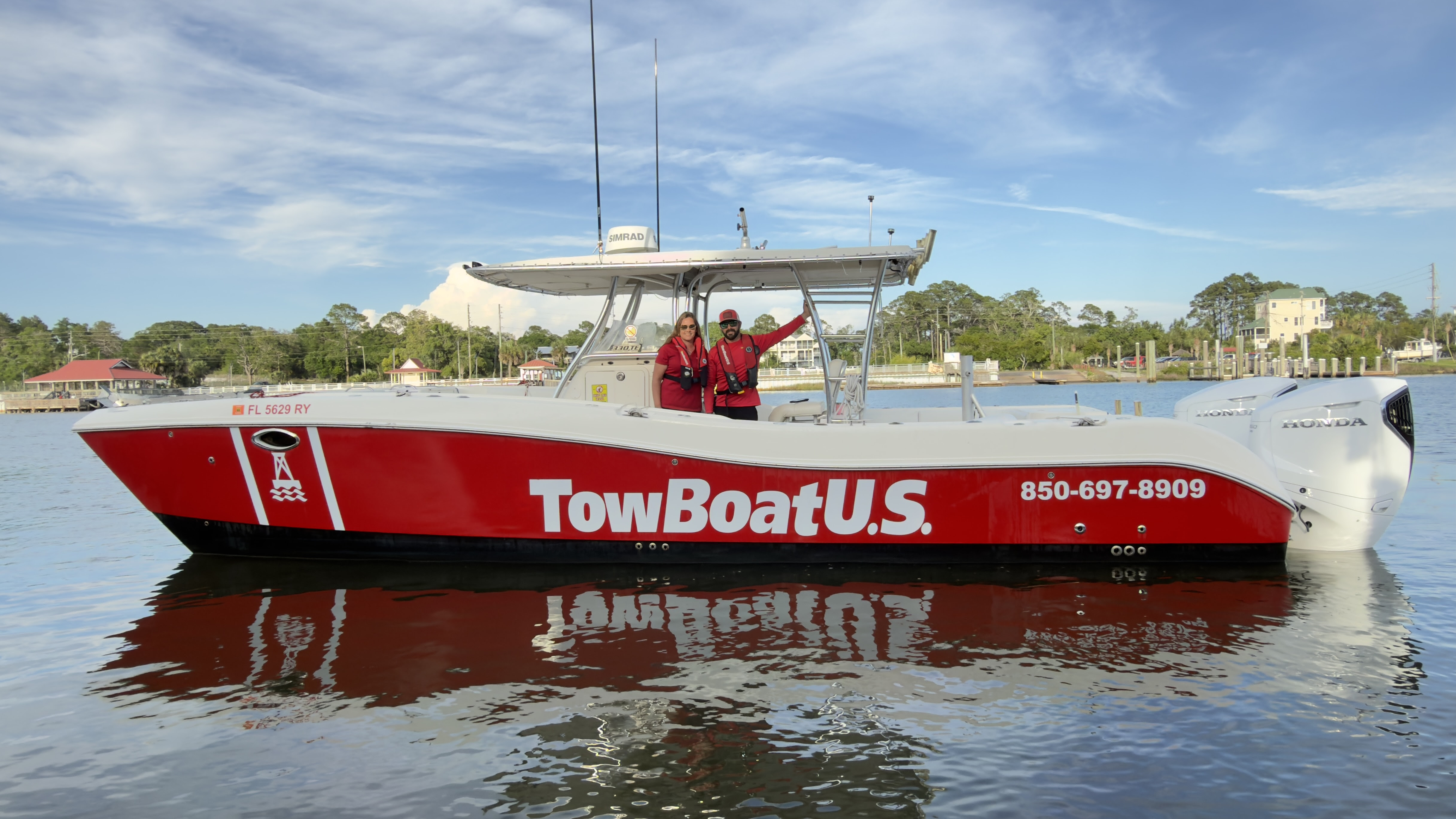
TowBoatUS Expands into Panama City, Strengthening Assistance for Recreational Boaters
TowBoatUS Expands into Panama City, Strengthening Assistance for Recreational Boaters
Capt. Daimin Barth adds fourth TowBoatUS port to ownership portfolio along Florida’s Panhandle
An image of Capt. Daimin Barth and his wife Amber Zigadlo
PANAMA CITY, Fla. – May 20, 2026 – TowBoatUS, North America’s largest network of on-water towing ports, announced today that U.
S. Coast Guard-licensed captain Daimin Barth has opened his fourth TowBoatUS port, TowBoatUS Panama City, continuing the brand’s growth to service it’s more than 152,000 BoatUS members across the state of Florida. Located in the heart of Panama City Beach, the port offers 24/7 on-water support to recreational boaters, including towing, fuel delivery, battery jumps, and soft ungroundings. Long-distance towing services beyond service areas listed on BoatU.S. member service locator may be available based upon conditions and availability. Separate from serving BoatUS Towing Members, the port also offers salvage, repairs, and prop disentanglement.
“As a captain-turned-port owner, I take pride in building on my experience responding to distressed boaters and know firsthand how fast response times can make all the difference,” said Barth. “With three existing locations across the Florida panhandle, we’ve strategically extended our reach geographically to better allow us to cover the region and respond to members quickly and when they need us most.”
The port will operate four TowBoatUS red response vessels crewed by U.S. Coast Guard-licensed captains, who are ready to respond to service calls. Vessels are strategically stationed at Sun Harbor Marina, Treasure Island Marina, a private dock in Parker, and on a trailer to service Deer Point Lake as well as other landlocked bodies of water. This distributed coverage allows the team to efficiently serve the entire Panama City Beach and Panama City area, reducing response times and ensuring help is always close by. The fleet ranges from 24 to 33 feet, enabling effective service in both shallow and deep-water conditions.
Much like an auto club for recreational boat owners, Boat Owners Association of The United States (BoatUS) offers on-water towing memberships for $215/year for saltwater. In addition to a BoatUS Towing Membership, members also receive more than 25 valuable BoatUS benefits including a subscription to award-winning BoatUS Magazine, free DSC-VHF radio registration and more.
To request on-water assistance, boaters can call the BoatUS toll-free 24/7 Dispatch Center at 800-391-4869, download the free BoatUS App, which connects boaters to the closest local towing captain, call TowBoatUS Panama City directly at (850) 697-8909, or hail on VHF radio Ch. 16.
###
About TowBoatUS
Boat Owners Association of The United States (BoatUS) is the nation’s leading advocacy, services and safety group for recreational boaters. We provide more than 740,000 members with a wide array of helpful services, including 24-hour on-water towing that gets boaters safely home when their boat won’t, as well as jump-starts, fuel delivery, and soft ungroundings. The TowBoatUS towing fleet is North America’s largest network of towing ports with more than 330 locations and over 630 red towboats, responding to more than 110,000 requests for assistance each year. To learn more about becoming a TowBoatUS member, visit BoatUS.com/Towing, and to find a TowBoatUS location closest to you, visit BoatUS.com/
ServiceLocator. You are receiving this email because you were included on Geico (Government Employees Insurance Company)’s media release. To unsubscribe and stop receiving emails from this organization click here.
Be the first to comment!
Celebrity Entrepreneur’s Death Spawns Insurance Shenanigans – Loose Cannon
Cruisers Net publishes Loose Cannon articles with Captain Swanson’s permission in hopes that mariners with saltwater in their veins will subscribe. $7 per month or $56 for the year; you may cancel at any time.


 Forwarded this email? Subscribe here for more
When all else fails, try journalism.
Celebrity Entrepreneur’s Death Spawns Insurance Shenanigans
Hoverboarder Hit by a Center-Console Five Years Ago; Epic Lawsuit Continues


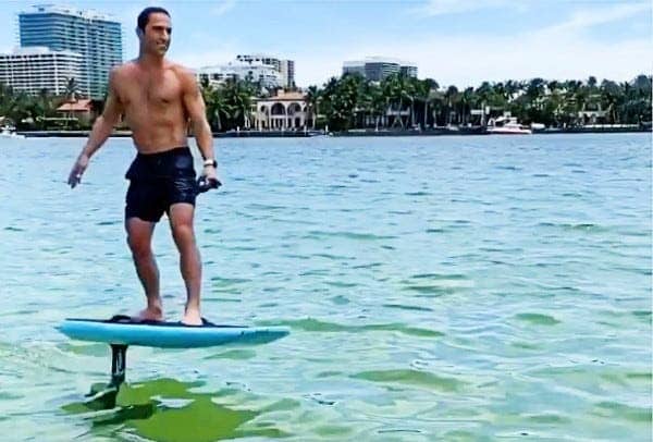
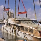
Aaron Hirschhorn died on March 28, 2021, while piloting his hoverboard in Biscayne Bay, Florida. He had collided with a center-console. (Instagram) Five years ago, the owner of a Chris Craft Launch 38 collided with a guy on an electric foil hoverboard, and he was pronounced dead at the scene. Aaron Hirschhorn, a celebrity entrepreneur, was survived by his wife Karen Nissim and their three young children
Insurance companies for the Chris Craft owners denied the Hirschorn family’s claim for compensation, spawning a legal battle so epic that it would rival the upcoming summer movie Odyssey with a legion of suit-wearing attorneys instead of helmeted Greek heroes. At stake is a $66 million arbitration award.
“The insurers denied coverage for the subject accident, declined to pay any amount on the claim, and refused to defend their insureds in litigation,” Lawyers for Karen Nissim wrote. In other words, the lead insurance company tried to walk away from their own clients on the basis of a couple technicalities—a move barred under Florida law.
Florida’s so-called “anti-technical” statute is “designed to prevent the insurer from avoiding coverage on a technical omission playing no part in the loss.”
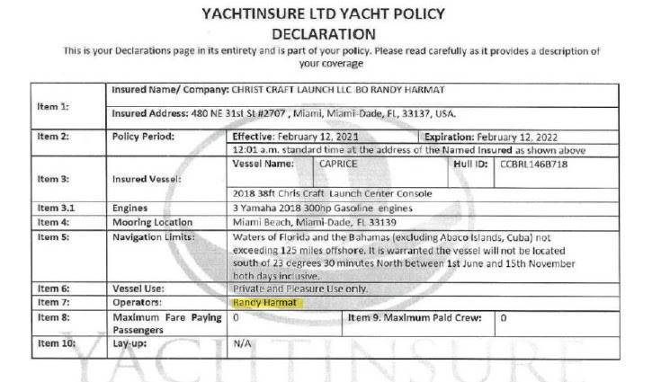
Another Big Insurance Win for Yacht Owner Under Florida Law
·July 17, 2023Read full story The recalcitrant insurance company is defendant Yachtinsure Services, a managing general agent and claims-management firm representing “actual insurers” Clear Blue Specialty Insurance and Aspen American Insurance Company, who each provided coverage to one of the two partners that owned Caprice.
(At this point it should be noted that one of the owners himself died a few months before the accident.)
According to the lawsuit, Yachtinsure refused to settle the claim against itself and the two companies or defend them in court.
Yachtinsure denied the claim under the dead owners’s policy because the live owner, who was operating the vessel, was supposedly an “unapproved operator.” This, even though the live owner’s separate policy—also administered by Yachtinsure— specifically listed live owner Randy Harmat as an operator.
So how did Yachtinsure deny coverage under the Harmat policy listing him as an operator? Kissim’s lawyers take up the story:
Coverage for the Harmat Policy claim was denied on the purported grounds that there was a “misrepresentation and failure to disclose material information related to a prior loss involving the Vessel.” The purported “misrepresentation” that justified its denial of the claim was the “fail[ure] to answer the question” on the insurance application whether “the vessel suffered any damage or undergone repairs in the last five years.”
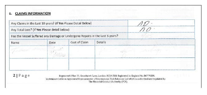
Which, of course, raised the question: If this were an issue, why was the policy issued to Harmat in the first place? Especially after the answer blocks appear to have been filled in, then erased. In May 2022, an arbitrator apportioned blame in the accident, deciding that Hirschhorn was 25 percent at fault, while the estate of the guy who died before the accident happened was 75 percent at fault. Based on Hirschhorn’s young age—he was 42 when he died—and the likelihood of future earnings, the arbitrator ruled that his family was entitled to $66 million even after factoring Hirschhorn’s own culpability.
Then in January 2024, Harmat the living owner agreed to the same settlement under the ancient legal doctrine of any party not at the table is on the menu.
Actually, it is called a Coblentz agreement, which refers to a negotiated consent judgment “entered into between an insured and a claimant in order to resolve a lawsuit in which the insurer has denied coverage and declined to defend.”
The agreement guaranteed that Hirschhorn’s survivors would not go after Harmat or his dead partner’s estate for the settlement—only the insurers.
Here’s where it gets interesting. Both insurance policies were limited to $500,000 payouts, but lawyers for the widow argued that, under Florida law. Yachtinsure’s “wrongful refusal to defend the claim” mean that those limits went out the window and the entire $66 million was at play.
Through its lawyers, Aspen Insurance argued that the arbitration award agreed to by the plaintiff and the boat owners “was not reasonable and is the result of collusion, fraud or lack of ‘good faith’.”
Aspen, which represented the dead owner, also argued that his policy died with him and that Aspen, therefore, didn’t owe Hirschhorn’s survivors a nickle.
That’s just a quick and undoubtedly incomplete summary of just one of five federal lawsuits arising from the untimely death of Aaron Hirschhorn. Some have been settled, but the central case had 284 document entries as of last week—with no sign of letting up.
Chief takeaways: Read your policy. Ask questions. Realize that Florida’s anti-technicality law may not be the case in your state.
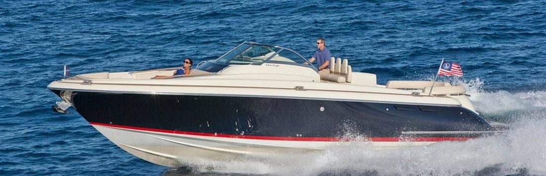
A sistership to the Chris Craft in question. LOOSE CANNON covers hard news, technical issues and nautical history. Every so often he tries to be funny. Subscribe for free to support the work. If you’ve been reading for a while—and you like it—consider upgrading to paid.
Be the first to comment!


Social Media Auto Publish Powered By : XYZScripts.com
Be the first to comment!