History of the Southwest Florida Waterway – Part 2
An interesting report on the early development of the Southwest Florida Waterway. See Part 1
Sunday Favorites: History of the Intracoastal Waterway Part 2 – Bradenton Times
Bradenton Times
An interesting report on the early development of the Southwest Florida Waterway. See Part 1
Sunday Favorites: History of the Intracoastal Waterway Part 2 – Bradenton Times
Bradenton Times
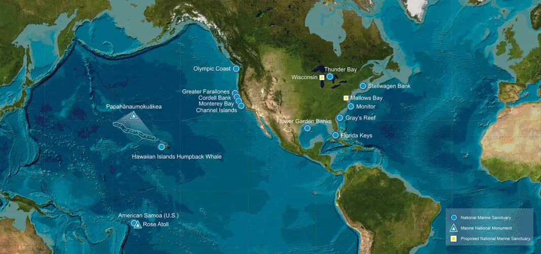
The US National Oceanic and Atmospheric Administration has announced the release of a “story map” to illustrate the effects of vessel noise on marine wildlife inside sanctuaries.
 by Sam Helmy
NOAA Releases Map With The Effects Of Vessel Noise On Wildlife
DeeperBlue.com
Abandoned and derelict boats are a growing problem all along the waterways of America, particularly in places that don’t freeze in winter. Today’s analysis suggests we will soon be seeing a tsunami of wrecks and soon-to-be wrecks, rendering today’s blight almost insignificant by comparison.
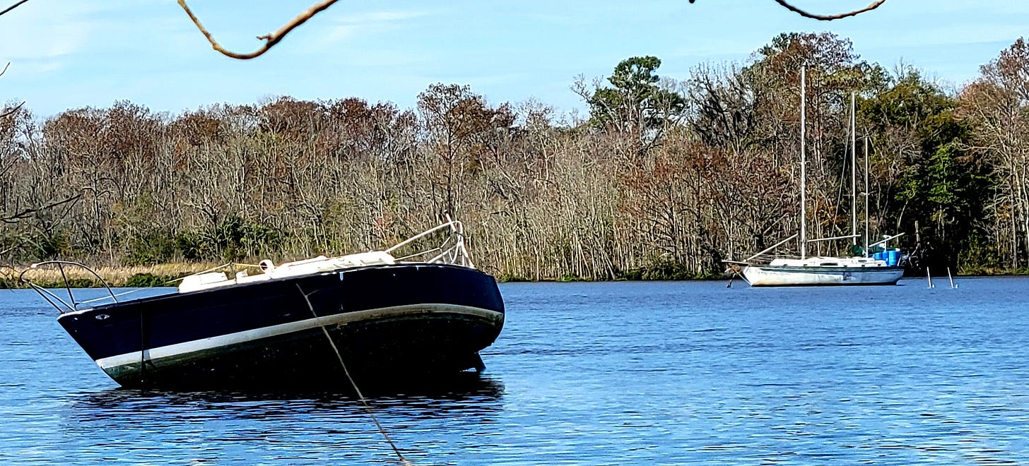
In Green Cove Springs, Florida, one boat is aground (there are four altogether) and another is anchored without an owner aboard, which appears to be the case for most of the other 20 or so vessels that have come here over the past few years.
Boating-Boom Bottom Line: A Derelict Vessel Tsunami by Peter Swanson
If you have not already done so, I would suggest you sign on to Loose Cannon as an excellent news source for the boating community especially as it relates to issues concerning us all no matter where you boat. Peter Swanson is a very season captain, newspaper editor. writer for boating magazines, specializing in Florida, Bahamas and Greater Antilles. Captain of excursion catamarans in the Dominican Republic. Cruiser: Nova Scotia to Caribbean. Delivery skipper. U.S. Coast Guard master's license.
|
|
|
My spouse and I went saltwater fishing in November with a couple of friends for three days on the Atlantic Intracoastal Waterway, along the North Edisto River, near Edisto Island, South Carolina (SC).
A Life Jacket Saved My Friend’s Life
dvids.net
UNITED STATES
01.21.2022
Story by Pamela Doty
U.S. Army Corps of Engineers, Water Safety
The Outer Banks county has a rich history of agriculture, political leadership and intriguing people, writes historian Eric Medlin.
Currituck County: More than a vacation destination
CoastalReview.org
The accuracy of future charts depends on all of us using NOAA Custom Chart today.
Help Wanted
Bob Sweet – Passage Maker
Know the potential warning signs of an incoming tsunami. Learn about the science of these dangerous waves to help you and your community stay safe!
| Learn the many ways Tsunamis are formed and how to stay safe if you are in the danger zone. |
|
The Florida Keys National Marine Sanctuary continues to offer a free, online course so boaters can learn how to protect themselves, their vessels, and the unique Keys marine environment.
Sanctuary offers free boating class online | Mile Markers | keysnews.com
Key West Citizen
|
An interesting report on the early development of the Southwest Florida Waterway.
History of the Intracoastal Waterway
Bradenton Times

View of the Intracoastal Waterway at Lido Beach circa 1946. Photo: State Archives of Florida
|
View of the Intracoasta Waterway at Lido Beach circa 1946. Photo: State Archives of Florida |
Sunday, Jan 16, 2022 |
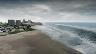
Back in the 1890s, when people were just starting to realize the agricultural potential of the area, it became clear that there was an advantage to transporting popular exports like citrus, vegetables, livestock, lumber and fish to neighboring villages through inland waters, which were sheltered from severe weather and could provide safe passages to shallow-draft vessels unable to go offshore.
Local communities requested the assistance of the federal government and the United States Congress committed $5,000 for the project. In 1895, the U.S. Army Corps of Engineers began dredging a 100-foot-wide channel, nine feet deep, that ran from southern Tampa Bay to Charlotte Harbor. The Intracoastal Waterway took 72 years to complete, according to document The Historical Development of the Gulf Intracoastal Waterway: The Boating Geography of Southwest Florida Before Development.
At the time, the 54-mile stretch from Tampa Bay to Gasparilla Sound included three separate bays that were not connected: Big Sarasota Bay; Little Sarasota Bay and Lemon Bay. These bays were separated by natural barriers, mostly mangroves, and had varying depths and navigability. Settlers were forced to sail around these barriers into open water, which left them vulnerable to choppy seas and unpredictable weather patterns.
The dredging occurred sporadically and began in south Tampa Bay with a series of cut-throughs. The first “cut,” joined Tampa Bay and Sarasota Bay in 1895. The following year, Sarasota Bay joined Casey’s Pass. In 1907, another cut through extended to Venice. The plan worked. By 1917, all sorts of goods were being transported safely from Tampa to Charlotte Harbor. Some of the major supplies were brick, canned goods, groceries, cement, corn, fertilizer, grain, ice and lumber. In 1919, Congress approved more funding for a wider channel to accommodate more traffic.
At the time, an experimental vessel was tasked with the dredging project. “Suwannee” was a U.S. steam snag boat, 100 feet in length with a shallow draft and a square bow. With the help of a 10-man-crew, she sucked slurry from the bottom and discharged it along the shore while a derrick lifted rocks and snags from the bottom. A launch, float boat and two rowboats accompanied her during the project.
The project went so well, that in 1939 the Board of Engineer for Rivers and Harbors recommended another intracoastal project reaching from Tarpon Springs to Fort Myers. A 3-foot-deep by 75-foot-wide channel existed from Sarasota to Venice. The Corps of Engineers surveyed Lemon Bay in 1899 but determined insufficient economic justification for dredging the southern inland waterway sector to Gasparilla Sound.
The sea robin is one weird-looking fish.
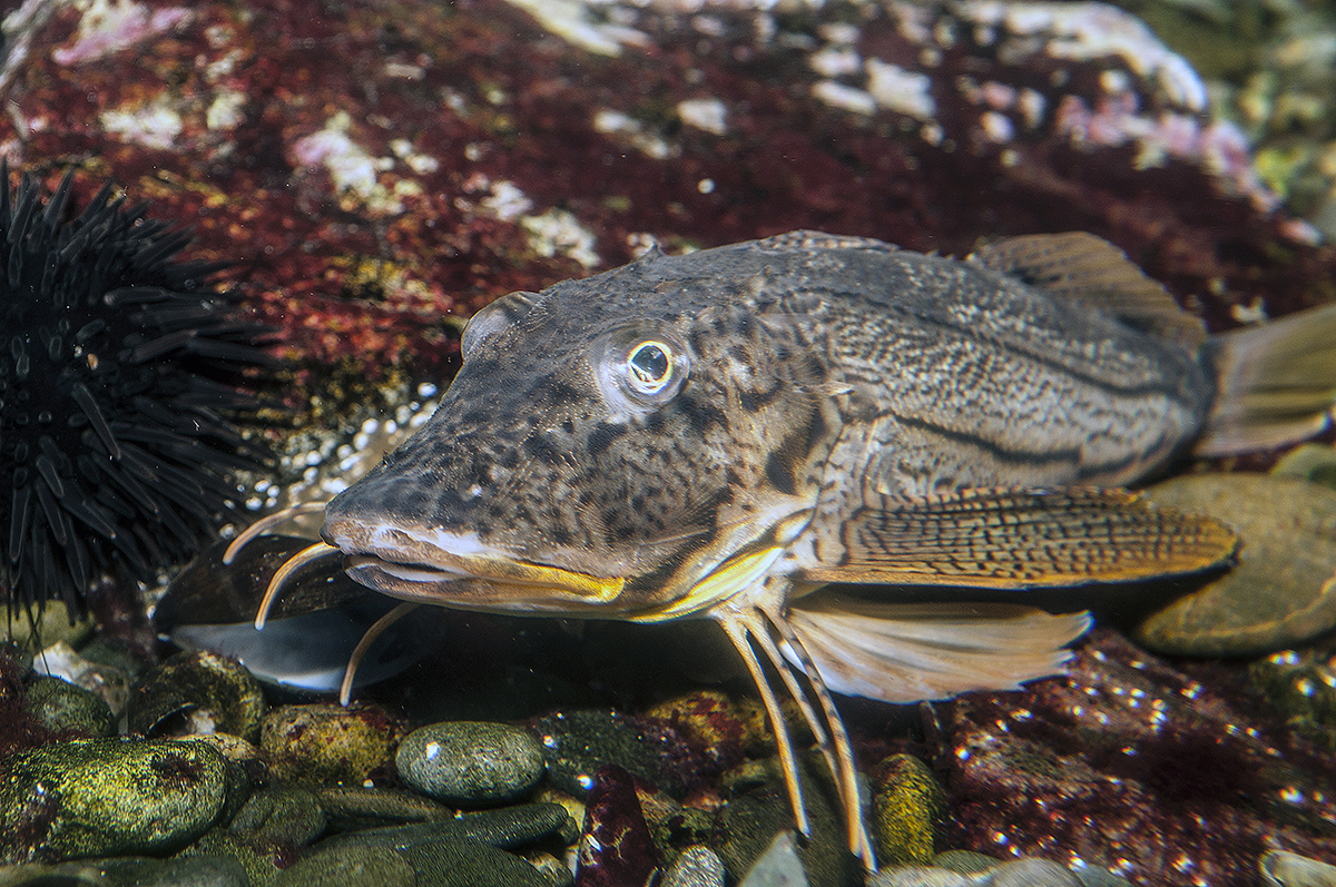
A striped sea robin. Photo: Robert Michelson
What’s on the line? It’s a bird, it’s a plane — it’s a sea robin
CoastalReview.org
Historian David Cecelski illustrates with a series of photographs life in 1930s and 1940s fishing communities as well as the man who took the photos, Charles Farrell.
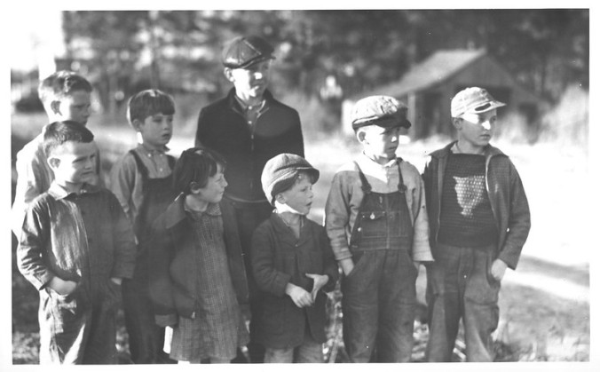
Manns Harbor, 1937-39. Photo: Charles A. Farrell, courtesy, State Archives of North Carolina
Lost photographs: Remembering NC’s fishing communities


Be the first to comment!