Visit Logged
  • Select Region
    • All Regions
    • VA to NC Line
    • North Carolina
    • South Carolina
    • Georgia
    • Eastern Florida
    • Western Florida
    • Florida Keys
    • Okeechobee Waterway
    • Northern Gulf
    • Bahamas
    • New York
    • Ohio
    • Pennsylvania
    • Washington
    • Puerto Rico
    • Minnesota
    • Maryland
    • Tennessee
    Order by:
    • FOCUS ON Harbour Town Yacht Basin, Hilton Head Island, SC, AICW Statute Mile 565


      Harbour Town at Hilton Head, with its familiar red-and-white-striped lighthouse, is a fine resort marina with an enormous number of amenities.

      Harbor Town Yacht Basin, A SALTY SOUTHEAST CRUISERS’ NET SPONSOR, lies just off the Atlantic Intracoastal Waterway on Calibogue Sound, below Statute Mile 565 at Marker 32, right in the heart of The Sea Pines Resort.

      Recently voted the 2015 “Marina of the Year” by Marina Dock Age magazine, the Harbour Town Yacht Basin has been a place for visitors and guests to enjoy world-class accommodations for over 40 years. Located in the heart of The Sea Pines Resort and on the Calibogue Sound, this full-service marina offers everything: shopping, dining, entertainment, watersports, fishing charters, cruises, and much more. Irrefutably Hilton Head Island’s most famous and visited marina, our amiable and experienced staff and Harbourmaster are dedicated to providing each visitor and guest with lifelong memories all amidst the spectacular backdrop of the iconic Harbour Town Lighthouse.
      C30A8407 (1)
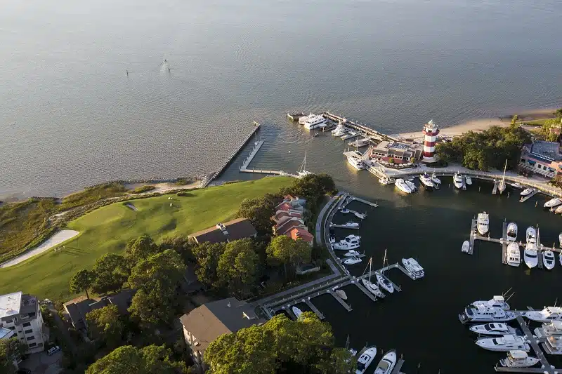
      The Harbour Town Yacht Basin was built in 1969 by legendary founder, Charles Fraser. Modeled after a famous harbor in Portofino, Italy, Harbour Town Yacht Basin was designed to attract visitors while preserving the natural beauty of the landscape. This included preserving the Liberty Oak, which was incorporated into the layout of the marina in lieu of building more slips. Centuries old, the Liberty Oak has stood as a symbolic landmark for wedding venues and concerts, but the most iconic image of the yacht basin is the Harbour Town Lighthouse. Constructed the same year as the marina, the lighthouse has welcomed visitors to one of the most beautiful and unique places on earth while offering one-of-a-kind views.
      tower
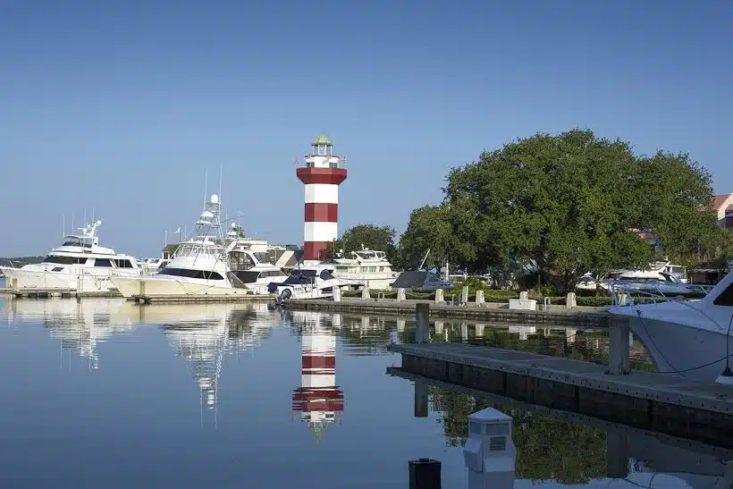
      Harbour Town Yacht Basin is an intimate marina that offers over 100 docking slips where visitors can dock nightly, monthly, or even for a lifetime. Modern facilities and exceptional service continue to contribute to the world-class resort experience that keeps guests coming back year after year. Guests and visitors at the yacht basin can enjoy world-class facilities throughout The Sea Pines Resort, such as the Harbour Town Clubhouse, the Sea Pines Beach Club, the Plantation Golf Club, and the luxurious Inn & Club at Harbour Town.
      rockers
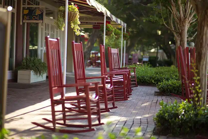
      Guests can enjoy charter fishing, cruises and sightseeing tours, as well as watersports at Harbour Town. Explore fertile fishing grounds with the island’s most experienced captains on a three-hour or overnight excursion aboard a fishing charter, observe various marine life from aboard a multi-passenger yacht during a sightseeing tour of Calibogue Sound and Daufuskie Island, or close up on a waverunner, kayak, or paddleboard.

      Click Here To View the Eastern Florida Cruisers’ Net Marina Directory Listing For Harbor Town Yacht Basin

      Click Here To Open A Chart View Window, Zoomed To the Location of Harbor Town Yacht Basin

      Be the first to comment!

    • FOCUS ON Windmill Harbour Marina, AICW Statute Mile 558


      Windmill Harbour Marina, Hilton Head SC

      Windmill Harbour Marina, A SALTY SOUTHEAST CRUISERS’ NET SPONSOR, is located hard by the southwesterly mouth of the Waterway’s passage south down Skull Creek, on the shores of Hilton Head Island, south of marker #27.

      Welcome to Windmill Harbour Marina, situated on the northwest coast of Hilton Head Island, South Carolina. We are located on the Intracoastal Waterway, just ½ mile south of the Pinckney Island Bridge at mile marker 558, 500 yards south of channel marker 27, and ½ mile north of channel marker 29 in the Calibogue Sound. The marina’s 15.5 acre harbour boasts 258 boat slips, offering many for short or long term rental or sale. Transient dockage is available including dining privileges at the Yacht Club, laundry, restrooms and showers, competitively priced fuel and a pump out station. Our remarkable harbour offers a safe, tide free haven protected by a lock system directly off the Intracoastal Waterway. The Windmill Harbour Marina lock is 75′ long by 19′ wide. Hours of operation are 0800 to 1900 by harbour master or 24 hours by yachtsmen with a keycard. We monitor channel 14 VHF and our phone number is 843-681-9235.
      One of only three private locked harbours on the east coast, Windmill Harbour Marina offers an unparalleled combination of convenience and security…the safest place to keep your yacht.

      windmill

      Windmill Harbour initially began in 1981, the founding company chose a Southwestern style featuring an adobe look and a large windmill at the entrance.  This design, however, was not embraced by the community. In response, the founders removed the windmill and the land plan changed to a mix of single-family homes, townhomes and condominiums in a more acceptable southern traditional style, similar to residences found in Charleston. As Windmill Harbour began to take shape, more and more homes were built in that style. This led to the evolution of the Charleston Lowcountry look one sees in Windmill Harbour today.
      Windmill Harbour is home to a variety of different boaters. From small center console fishing boats to large offshore sport fishing boats, fertile fishing grounds are nearby. A significant fleet of Harbor 20s engages in class racing and there are numerous cruising and sailing activities including the Calibogue Cup, Harbour Town Cup and Ocean Challenge.

      windmill2 windmill3

      One of the most important assets of the community is the marina and its unique harbor. The harbor is composed of 15.5 acres and houses more than 255 boat slips and is the largest harbor on Hilton Head Island by nearly a hundred slips. The lock was constructed to create a protected harbor from the weather and the changing tides. It was only the second lock existing on the eastern seaboard at the time. The lock is operated with the gravity flow of water, electricity and hydraulics. As complicated as it may appear, it is very simple to operate.

      VIDEO

      VIDEO

      As the marina and neighborhood came together the next step was to give the community a place to gather. Thus the South Carolina Yacht Club was born. The vision was that the club would be populated by the most interesting residents and visitors to Hilton Head Island, reminiscent of those early social gatherings on Hilton Head. This led to the decision which established a club that property owners could choose to join, but were not required to do so, and that would invite membership from outside of Windmill Harbour and Hilton Head as well. More detailed information on the founding of the South Carolina Yacht Club can be found on its website.

      windmill5

      The unique history, breathtaking beauty, meticulous planning and unique harbor have made Windmill Harbour a premier marina community in the Lowcountry. Its vibrancy and growth are a testament to its founders and its residents.

      Click Here To View the South Carolina Cruisers’ Net Marina Directory Listing For Windmill Harbor Marina

      Click Here To Open A Chart View Window, Zoomed To the Location of Windmill Harbor Marina

      Be the first to comment!

    • More Good Words for Downtown Marina of Beaufort, SC, AICW Statute Mile 536.5


      The Downtown Marina Of Beaufort, SC, 1006 Bay Street Beaufort, SC 29902 (843) 524-4422 or Marker #239 on ICW

      A SALTY SOUTHEAST CRUISERS’ NET SPONSOR!, Downtown Marina is located north of AICW marker #239, a short distance west of the Lady’s Island swing bridge, in the heart of downtown Beaufort.

      Great stop! The marina staff is very good with the tides and the rolling current. Diesel pump was VERY slow, but price reasonable. Could not ask for a better place to shop and eat! Plenty of restaurants to choose from, and cute little shops to browse. This is our second time here, and will return!
      Still Clueless

      Click Here To View the South Carolina Cruisers’ Net Marina Directory Listing For Downtown Marina

      Click Here To Open A Chart View Window, Zoomed To the Location of Downtown Marina of Beaufort

      1 Facebook Likes, 1 Facebook Reactions

      Be the first to comment!

    • Praise for Windmill Harbour Marina, AICW Statute Mile 558


      Windmill Harbour Marina, A SALTY SOUTHEAST CRUISERS’ NET SPONSOR, is located hard by the southwesterly mouth of the Waterway’s passage south down Skull Creek, on the shores of Hilton Head Island, south of marker #27. Our thanks to Bob Miller for these kind words for one of our fine sponsors!

      Just wanted to comment on the staff and marina facilities at Windmill Harbour . We kept our 43′ motor yacht there over this past winter (2015-16) and believe there is no better choice in the Hilton Head area. Very professional marina staff and pleasant location. The marina is in a gated community so it is safe and secure, and the marina is protected by a lock system which keeps the water depth constant in the marina. It is home to the South Carolina Yacht Club so many nice boats and activities. They welcome transient boaters as well as those for longer stays. One thing to be aware of is that access to stores and restaurants will require transportation as it is a residential area.
      Bob Miller

      Click Here To View the South Carolina Cruisers’ Net Marina Directory Listing For Windmill Harbor Marina

      Click Here To Open A Chart View Window, Zoomed To the Location of Windmill Harbor Marina

      Be the first to comment!

    • Voyaging Canoe Hokulea Coming to Charleston, SC, AICW Statute Mile 465

      Click Here to read – and hear- this report from Hawaii Public Radio. Look for them as you migrate north!

      Voyaging Canoe Hokulea Navigates Florida Waterways
      By MOLLY SOLOMON • 4 HOURS AGO

      canoe

      CREDIT OIWI TV / MAUI TAUOTAHA

      Voyaging canoe Hōkūle‘a is continuing her journey up the East Coast of the mainland. The canoe recently left Titusville, Florida and is traveling along the Intracoastal Waterway, where she’s encountered new wildlife and a whole lot of aloha.
      HPR’s Molly Solomon checked in with navigator Bruce Blankenfeld as part of our ongoing coverage Hōkūle‘a: Voyage of Aloha.
      Hōkūle‘a’s next stop is Charleston, South Carolina — then it’s on to Virginia and New York in June.

      April 14, 3:30PM

      Hokulea approaching Charleston Maritime Center

      IMG_0755

      The crew of Hokulea was greeted by a contingent of native Hawaiians who now live in the Charleston area. The greeting included drumming and conch blowing.

      Drummers

      Drummers

      2 Facebook Likes, 2 Facebook Reactions

      Comments from Cruisers (1)

      1. wooduck -  April 18, 2016 - 6:08 pm

        Awesome! Incredible journey! Hope she is stopping in Beaufort. Watching the icw cam @ Wrightsville bridge for another wonderful glimpse of unique, untold, maritime history!!

        Reply to wooduck
    • FOCUS ON Georgetown, SC, AICW Statute Mile 403


      VHF 16 & 68 Located on the Sampit River, Harborwalk Marina is only a boardwalk away from Georgetown's Historic District, great food, shopping, etc. A safe harbor from bad weather and located in calm

      The County Chamber of Commerce for Georgetown County, South Carolina and Salty Southeast Cruisers’ Net are delighted to share the rich history of this area’s earliest settlements in and around Winyah Bay and along the several rivers that converge near Georgetown. The preserved old southern rice and indigo plantations still provide glimpses into our country’s earliest commercial, agricultural and aqua-cultural endeavors. Providing easy access to this “stroll-worthy community” for the cruising community is the recently completely renovated Harborwalk Marina, A SALTY SOUTHEAST CRUISERS NET SPONSOR. Putting Georgetown, SC on your list of fun ports of call is a must.

      Looking for a great place to take a brief respite from the ICW? Then take a turn at marker 40 and head up the Sampit River to Historic Downtown Georgetown.

      gtbigharbor

      Georgetown Harbor – Sampit River

      Dockage is available at several marinas, and there are day docks on the City’s Harborwalk. The third oldest city in South Carolina, Georgetown has been welcoming visitors to their harbor for almost 300 years.

      Front Street Shopping

      Front Street Shopping

      Once you arrive in Georgetown and find a dock or anchorage, it’s time to start exploring the area. Within easy walking distance (just a few blocks) there are more than 14 restaurants, five museums and an abundance of shops. The locals are friendly and always glad to welcome visitors.

      Stewart Parker House - facing the river

      Stewart Parker House – facing the river

      Start your exploration at the Chamber of Commerce Visitors Center, next to Harborwalk Marina. There you will get free information including maps of the area, local attractions and history. Make time to visit all our museums – each highlights a different aspect of the rich history of the area.

      Keith House B&B on Front Street

      Keith House B&B on Front Street

      The Rice Museum highlights the history of rice production in the area. Did you know Georgetown County was the largest producer of rice in North American in the early 1800’s? You will also have the opportunity to see the remains of the oldest wooden vessel known to have been built in North America.

      The South Carolina Maritime Museum on the Harborwalk celebrates the maritime history of the state and port of Georgetown. Exhibits include historic photographs, documents, artifacts, and interactive displays. The centerpiece of the museum is the 5th order Fresnel lens that was the heart of the North Island Lighthouse for over 100 years. The Museum is also the home of the annual Georgetown Wooden Boat Show, which has been named a Top 20 Event in the Southeast and won the Bundy award as one of the best events in the state.

      gtbiglens

      Fresnel Lens from North Island Lighthouse

      gtbigkids

      Kids at Maritime Museum


      Georgetown County Museum features artifacts from all over the county, including a handwritten letter from General Francis Marion, the Swamp Fox. The Gullah Museum celebrates the Gullah culture of the western African people that were brought to our shores against their wills in the 1700 and 1800’s, and forged a shared culture that shaped the landscape, food and language of the Lowcountry.

      Kaminsky House Museum

      Kaminsky House Museum

      The Kaminski House Museum, dating from 1765, features an extraordinary collection of European and American antiques, along with a glimpse into the history of Georgetown.

      Georgetown’s National Register Historic District along the harbor is home to over 63 structures over 200 years old. You can pick up a historic walking map for a do-it-yourself tour or jump on the Swamp Fox tour trolley and enjoy an hour long narrated excursion through the oak-lined streets. You’ll be regaled with almost 300 years of history and may even hear a ghost story or two. Love ghost stories? Ask at the Visitors Center about one of our local lantern-led evening ghost tours!

      Make sure you plan to spend several days in our harbor. You will need that much time to experience all the sites and sample all the amazing restaurants within a few steps of the water. Many Thursday evenings you can also enjoy free concerts in Francis Marion Park, right on the Harborwalk. One thing we can guarantee, you’ll leave a visit to Georgetown having made new friends and planning your return trip.

      Click Here To View the Cruisers’ Net’s South Carolina Marina Directory Listing For Harborwalk Marina

      Click Here To Open A Chart View Window, Zoomed To the Location of Harborwalk Marina

      Comments from Cruisers (1)

      1. Bob Asby -  April 11, 2016 - 11:36 am

        Fond memories of cruises north & south from the Chesapeake to Florida ……………. Bob Asby

        Reply to Bob
    • Happy Hour on the Megadock, Charleston City Marina, AICW Statute Mile 469


      city

      Charleston City Marina is welcoming its transient guests with a free Happy Hour on the Megadock Monday, Tuesday, Thursday and Friday evenings with live music on Thursdays beginning in May. Charleston City Marina, A SALTY SOUTHEAST CRUISERS’ NET SPONSOR, is located along the Ashley River’s northeastern banks, northeast of marker #5.

      happy

      Click Here To View the South Carolina Cruisers’ Net Marina Directory Listing For Charleston City Marina

      Click Here To Open A Chart View Window, Zoomed To the Location of Charleston City Marina

      Be the first to comment!

    • A Driver’s Perspective on Ladys Island Swing Bridge Closures, AICW Statute Mile 536


      Fran is expressing exactly the frustration that we are experiencing here in Charleston. More and more development on our coastal islands is underway without adequate supporting construction of roadways and bridges to accommodate the resulting increase in vehicle traffic. Until planners either wake up to the downside of rampant development, drivers and boaters alike are going to continue to suffer long waits during rush hours or in emergency evacuations. SSECN asks, that as you confront fewer and fewer bridge openings, please be patient! Rarely is delayed vessel travel as dangerous as miles of backed up idling vehicles. And DO NOT yell at the Bridge Tender! It is NOT their fault. If you want to yell at someone, yell at the developers and city planners!
      Fran is responding to an earlier comments on Ladys Island Bridge in Beaufort, SC.

      I live on Lady’s Island and work in Burton. If anyone traveling from Beaufort to Lady’s Island or the outer Islands thinks there is NOT a traffic problem when this bridge opens and closes, they are delusional. I’ve lived at my residence since 1976. The growth on the Lady’s Island side is enormous and once the Wal-Mart is built, it will be a nightmare. It [congestion] already is when the Woods Bridge breaks down. The McTeer Bridge is not adequate to accommodate traffic to or from Lady’s Island, St. Helena, Fripp Island, etc. The only solution to this issue is to build another bridge or limit the bridge openings. Traffic backs up well beyond Bellamy Curve during rush hours in the evening. I can’t even imagine what traffic is going to be like should a hurricane head to Beaufort. Well, actually I can. During Hurricane Fred it took two hours to get from Lady’s Island to the National Cemetary on Boundary… and 11 hours to get to Atlanta. People will need to evacuate Beaufort a week in advance of hurricane at the rate the population of Beaufort is growing on the Lady’s Island side.
      Fran H

      Click Here To View the Cruisers’ Net’s South Carolina Bridge Directory Listing For Ladys Island Bridge

      Click Here To Open A Chart View Window, Zoomed To the Location of Ladys Island Bridge

      Comments from Cruisers (1)

      1. RBEmerson -  March 19, 2016 - 8:24 am

        Having driven in the area, too, I certainly agree that the bridge is a major bottleneck for road traffic. But it’s equally a nightmare for water traffic. I remain amazed that a fixed bridge hasn’t replaced the swing bridge. I understand that finding a suitable site, that doesn’t harm Beaufort and the community on Ladys Island will be a challenge. Nonetheless, it’s something South Carolina should have done years ago.

        In the meantime, we will continue to avoid the area, which currently effectively blocks the AICW rather than find a solution that serves land and water traffic.

        Reply to RBEmerson
    • Georgetown Restaurant Praised, Georgetown, SC, AICW Statute Mile 403


      VHF 16 & 68 Located on the Sampit River, Harborwalk Marina is only a boardwalk away from Georgetown's Historic District, great food, shopping, etc. A safe harbor from bad weather and located in calm

      As Claiborne would have said, news of good food is always welcome! So we thank Bob and Susan Crenshaw for these good words for a new Georgetown restaurant, especially as this lovely port is recovering from a devastating fire in 2013 that destroyed a number of waterfront cafes. Harborwalk Marina, A SALTY SOUTHEAST CRUISERS’ NET SPONSOR, is the northwesternmost marina on the downtown Georgetown/Sampit River waterfront.

      Cruising News
      Great new restaurant in Georgetown DiAngelo’s
      We just had a wonderful dining experience at DiAngelo’s on 929 Front street in Georgetown. We had opportunity to meet the owner, Pat DiAngelo and his wife Debbie. Also the chef, Tony came out and introduced himself. A.J. was our server.
      Wonderful home made Italian food that was fantastic. Chef Tony prepared us a sample of his yet unnamed dumpling gnocchi dish that was fantastic.
      Then to top off the nite he brought us some samples of Zeppoli, an Italian doughnut that melted in your mouth. These are wonderful people who need to be supported to make their business successful. The owner, Pat, was very gracious and appreciative of his customers. We cannot recommend a better dining experience than one we had.
      The kicker is that Chris, Dockmaster at Harbourwalk recommend we try them out. You will not be disappointed.
      Bob & Susan Crenshaw
      Carolina Girl

      Click Here To View the Cruisers’ Net’s South Carolina Marina Directory Listing For Harborwalk Marina

      Click Here To Open A Chart View Window, Zoomed To the Location of Harborwalk Marina

      2 Facebook Likes, 2 Facebook Reactions

      Be the first to comment!

    • Shallow Water Reported at McClellanville Problem Stretch, AICW Statute Mile 432


      This Problem Stretch is perennially the source of shallow water reports and over the years we have received numerous complaints of skinny depths in this narrow Waterway channel, from south of the intersection with Jeremy Creek and McClellanville to Statute Mile 435. As always, SSECN recommends mid to high tide passage if you draw 5ft or more! Our thanks to Captain Bob Crenshaw for this onsite report.

      Cruising News
      Extremely low water at SM 430 between 430 and SM 432 at Jeremy Creek
      We were coming north in our 42 trawler with 4 foot draft and encounter extreme low water with ranges from 4 to 6 feet. This occurred between SM 430 and 432 at Jeremy Creek near McClellanville. We had to monitor depth finder and pull back to idle speed as we mover thru the low water.
      This occurred at two hours before low tide. It was extremely nerve racking trying to find the deep water. When we arrived at our destination at Georgetown we were told,that two boats that had planned to stay at Georgetown had called in and said they had gotten aground in this area and had to wait for tide to come back.
      We are unable to provide safe path in this area except monitor depth finder and try to search out low water.
      Carolina Girl
      42 Trawler
      Captain Bob Crenshaw

      Click Here To View the Cruisers’ Net’s “AICW Problem Stretches” Listing For the Waterway south of McClellanville.

      Click Here To Open A Chart View Window, Zoomed To This AICW Problem Stretch

      Be the first to comment!

    • Praise for St. Johns Yacht Harbor, Charleston, SC , AICW Statute Mile 472.5


      For those who own a boat and love the water, buying a SJYH wet slip is an easy decision when you consider the benefits. The opportunity to own waterfront access a mere 11 minutes from historic downto Located on the western shore of the Stono River just south of the Waterway’s passage out the western/southern mouth of Wappoo Creek – Elliot Cut, and only a very short cruise from Charleston Harbor, St. Johns Yacht Harbor is A SALTY SOUTHEAST CRUISERS’ NET SPONSOR! By boat or by car, it is worth a trip just to see these beautiful facilities with probably the nicest Captains’ Lounge and Clubhouse on the east coast!

      Very nice, clean facility. Friendly and helpful staff. Convenient location. Grocery, drug stores and restaurants close by with courtesy car provided. Current can be tricky when tide is running,, but staff will assist with lines when docking. Will stop here again and recommend it highly to others.
      Capt Jack B-H and 1st mate Steve O.
      Aboard the trawler “Whatever”

      Click Here To View the South Carolina Cruisers’ Net Marina Directory Listing For St. Johns Yacht Harbor

      Click Here To Open A Chart View Window, Zoomed To the Location of St. Johns Yacht Harbor

      Be the first to comment!

    • Good Visit to Hilton Head Harbor, AICW Statute Mile 557


      Hilton Head Harbor RV Resort and Marina overlooks the Waterway’s southwestern shoreline opposite marker #20, north of Calibogue Sound.

      Hey all I stopped for 3 days due to sickness and Jack and Bourbon were both friendly and they checked in on me regularly. If your looking for good food and a good nights sleep give them a try. The restaurant was pricey but the food is great and the ladies will go the extra mile. I was so sick and the restaurant gave me a big bowl of soup and would not take a penny. If you stop make sure you have a biscuit for Bourbon, Jack’s Labrador and give him a hug from me. Before you leave don’t forget to top off your tanks as the fuel is the lowest price around.
      M&M’s Delite

      Click Here To View the South Carolina Cruisers’ Net Marina Directory Listing For Hilton Head Harbor

      Click Here To Open A Chart View Window, Zoomed To the Location of Hilton Head Harbor

      Be the first to comment!

    • Dredging Promised at Breach Inlet Problem Stretch, AICW Statute Mile 459


      This article by Prentiss Findlay in Charleston’s Post and Courier is a second follow up to his earlier piece on much needed dredging in the Problem Stretch at Isle of Palms area of the Waterway, /?p=150352. As before, SSECN recommends SLOW passage at mid to high tide.

      Inland Waterway at Breach Inlet to get long-awaited dredging
      Prentiss Findlay
      Prentiss Findlay Email Facebook @prentissfindlay
      Nov 13 2015 12:26 pm Nov 13 4:50 pm
      The Intracoastal Waterway at Breach Inlet will be dredged to improve navigation.
      Dredging of the dangerously shallow Intracoastal Waterway at Breach Inlet between Sullivan’s Island and Isle of Palms begins this week, the U.S. Army Corps of Engineers said.
      `It’s long overdue,’ said Charleston County Councilman Dickie Schweers.
      The county contributed $500,000 to the nearly $3 million effort which includes work in McClellanville to dredge a waterway channel for fishing trawlers.
      Some $2.4 million in federal funds has been authorized for both projects.
      `This project is a prime example of how collaboration between federal and non-federal partners for dredging can lead to increased waterway maintenance,’ said Brad Pickel, executive director of the Atlantic Intracoastal Waterway Association.
      The waterway at Breach Inlet is almost dry at low tide because of shoaling, a condition in which sand builds up and blocks the channel. The authorized channel depth is 12 feet and the width is 90 feet.
      Waterway dredging at the inlet will last about a week, said Glenn Jeffries, Corps spokeswoman.
      Mile-long Jeremy Creek in McClellanville, which is part of the waterway, will be dredged starting in mid-January, Jeffries said.
      `This schedule is tentative. Weather and machinery have a lot to do with a dredging schedule. But we will start in Breach Inlet for sure,’ she said.
      The last substantial funding the Army Corps received for waterway dredging was in 2009 through the American Recovery and Reinvestment Act.
      Waterway conditions at Breach Inlet at low tide have been blamed for boating injuries. `There’s just been a huge safety issue out there,’ said IOP City Administrator Linda Tucker.

      A Mount Pleasant woman was seriously injured in a 2013 boating accident blamed on the shallow waterway. She was traveling in a 44-foot trawler drawing 3 feet 10 inches of water that hit bottom. The impact caused her to fall. Doctors determined she had a fractured vertebrae, a concussion and a broken rib. She spent two nights in the hospital, officials said.
      IOP Marina and Charleston City Marina lose customers because recreational vessels often go offshore to avoid the waterway here, said IOP Mayor Dick Cronin.
      `They just basically have bypassed our marina and the city marina to a large extent,’ he said.
      Sen. Lindsey Graham’s office was instrumental in getting funds for the dredging, Cronin said.
      `We had appealed to everybody and their brother,’ he said.
      In McClellanville, Jeremy Creek is the route to two seafood processing plants. But it has become a muddy mess that idles trawlers for long stretches of the day, said Mayor Rutledge Leland.
      `It’s getting worse and worse. Every time you see a boat moving anywhere from half-tide on down there’s mud boiling up behind it,’ he said.
      After dredging, the creek will be eight feet deep at low tide, he said.
      `That should help for a couple or three years anyway. It will start silting immediately. We’ll have to start arguing and lobbying and begging almost as soon as they get through but that’s the way it works to get ourselves into the next budget,’ he said.
      The creek was created from mud flats as part of the original waterway project, he said.
      Some states, such as Florida and North Carolina, have dedicated funding for waterway maintenance. The Florida Inland Navigation District collects about $20 million annually to pay for waterway maintenance in 12 counties. North Carolina funds waterway maintenance through boater registration fees and the gas tax.

      Click Here To View the Cruisers’ Net’s “AICW Problem Stretches” Listing For the AICW North of Ben Sawyer Bridge to Isle of Palms Bridge

      Click Here To Open A Chart View Window, Zoomed To This AICW Problem Stretch

      Be the first to comment!

    • Free Electronics from Intracoastal Yacht Sales

      Our focus is to assist boaters with the purchase or sale of their powerboats. All our yacht owners are trained and educated on the handling and systems of their new vessel as part of our service. We want to make sure your experience with us is easy by being thorough with your needs. Through aggressive internet marketing, publication ads, and our long term networks we also have the resources to get your yacht sold! Our experience allows us the understanding of the market place. Intracoastal Yacht Sales, a long-time SALTY SOUTHEAST CRUISERS’ NET SPONSOR, offers full service brokerage representation from three locations, Wrightsville Beach, NC, Little River, SC and Charleston, SC.


      IntracoastalYachtSalesLogo

      Get Free Electronics When You Purchase Your New Boat!
      Purchase any one of our Stock Boats, or Build your very own boat between Now and January 1, 2016 and get a FREE Chartplotter, Autopilot, and VHF Installed at no cost to you! Pick the brand you like and have us install it for you at no charge!

      Garmin 1040xs Chartplotter $2,099.99 Value FREE

      Garmin 1040xs Chartplotter
      $2,099.99 Value FREE

      Garmin VHF-100 Marine Radio $249.99 Value FREE

      Garmin VHF-100 Marine Radio
      $249.99 Value FREE


      garminauto

      Garmin GHP20 Autopilot $4,049.99 Value FREE


      34 Nordic Tug – In Stock Now

      marlow

      31 Marlow-Mainship Available Now!


      CLICK HERE
      For a Virtual Tour of our 34 Nordic Tug In Stock Now

      CLICK HERE
      For More Information on our 31 Marlow-Mainship Available Now!
      NEW AND BROKERAGE BOATS AVAILABLE

      Click to here to visit more yachts for sale in the Carolina’s!

      www.intracoastalyachtsales.com

      Or Call Capt. Ric Stanley in Wrightsville Beach NC at 910-297-4444

      Capt. Doug Ford in Little River SC at 843-340-0080

      Capt. Bobby Gregory in Charleston SC at 843-412-6587

      Be the first to comment!

    • Herl Report: Ladys Island Marina, Beaufort, SC, AICW Statute Mile 536.5


      Ladys Island Marina - Beaufort, SCLadys Island Marina, A SALTY SOUTHEAST CRUISERS’ NET SPONSOR, continues making improvements in the marina portion of this property under the direction of owner, Kelly Ryan, as confirmed by the positive comments SSECN has received. Ladys Island Marina is located on Factory Creek just east of Ladys Island Bridge.

      Ladys Island Marina
      Arrived to a rousing welcome of “welcome home”. As you recall we were here last spring for a month. What a wonderful place. All needs are close and everyone here is very friendly. Shopping area for projects and lots of eateries very close. Love this place.
      Phil and Sandy Herl

      Click Here To View the Cruisers’ Net’s South Carolina Marina Directory Listing For Ladys Island Marina

      Click Here To Open A Chart View Window, Zoomed To the Location of Ladys Island Marina

      Be the first to comment!

    • Good Advice for Problem Stretch North of Ben Sawyer Bridge, AICW Statute Mile 460


      Southport Marina This good advice was forwarded to us by Hank Pomeranz at Carolina Yacht Care of Southport Marina, A SALTY SOUTHEAST CRUISERS’ NET SPONSOR! Skipper Wehmer has been communicating with Hank about Problem Stretches he had encountered. Funding for dredging the Problem Stretch north of Ben Sawyer Bridge has been approved but has not yet begun. See /?p=149544. SSECN continues to recommend mid to high tide passage for this stretch.

      Hank,
      From connector bridge to Ben Sawyer:
      Favoring the red side found more water as suggested. At G117A and B a sailboat in front of us drawing 6.5′ went aground staying to the far red side. They had approx. 1.5′ of tide. They radioed us and suggested to stay 40′ off of those buoys, which we did and had about 8′ MLW.
      For the balance of the passage, the notes you provided were good. If you draw 6 feet or over, we recommend waiting until there is at least 3′ of tide before making the trip, however, other than grounding next to 117A, the boat in front of us made it through with 1.5-2′ of tide.
      We are going to try to go outside from here to Fernandina, but if we do not, I’ll send you what we find.
      Bill Wehmer
      S/V Island Bound

      Click Here To View the Cruisers’ Net’s “AICW Problem Stretches” Listing For the AICW North of Ben Sawyer Bridge to Isle of Palms Bridge

      Click Here To Open A Chart View Window, Zoomed To This AICW Problem Stretch

      Be the first to comment!

    • Good Advice on Isle of Palms Problem Stretch, AICW Statute Mile 459


      Southport Marina This good advice was forwarded to us by Hank Pomeranz at Carolina Yacht Care of Southport Marina, A SALTY SOUTHEAST CRUISERS’ NET SPONSOR! Skipper Wehmer has been communicating with Hank about Problem Stretches he had encountered. Funding for dredging between the IOP Connector and the Ben Sawyer Bridge has been approved and one can only hope that the Isle of Palms Problem Stretch will also be dredged. See /?p=149544. SSECN continues to recommend a high tide passage for this stretch.

      Hank,
      We transited from Isle of Palms to Charleston yesterday.
      The stretch between IOP marina and the IOP connector bridge: Stay in middle as suggested. We strayed right of center to see how depths were and it shallows very quickly from center. Lowest spot we saw was about 50 yards before the bridge at 3.4 MLW in the middle of the channel. Otherwise we saw 7-10′ MLW.

      We are going to try to go outside from here [Charleston] to Fernandina, but if we do not, I’ll send you what we find.
      Bill Wehmer
      S/V Island Bound

      Click Here To View the Cruisers’ Net’s “AICW Problem Stretches” Listing For the AICW North of Ben Sawyer Bridge to Isle of Palms Bridge

      Click Here To Open A Chart View Window, Zoomed To This AICW Problem Stretch

      Be the first to comment!

    • Herl Report: Charleston and the Harborage at Ashley Marina, near AICW Statute Mile 469


      The Harborage at Ashley Marina lies along the northeastern shores of Ashley River (on the Charleston peninsula), between the charted 56 foot fixed bridge, and the 18-foot Highway 17 bascule bridge.

      Ashley Marina
      Arrived at Ashley on Sunday 10/11/15, the tide was still rather strong and we had a small problem trying to get docked but we did get docked.
      Monday. We wanted to see as much as we could, so we hit the Visitor Center first and then walked across the street to the Carolina History Museum. Spent about 4 hours in all. Both are very good and would highly recommend both for any visit.
      Tuesday. We hopped on one of the free trolleys that are about 20 min walk from the marina and again went down to the Visitors Center, changed trolleys and traveled to Market Street. Again this was more than we realized it would be. We ended up spending almost 3 hours there and then walked down three blocks to Sticky Fingers for a big batch of ribs, corn on the cob, baked beans and drinks, Wow. Very very good, so good we decided to walk some more. On the way we were asked to be shown a Methodist church that is the oldest Methodist congregation in Charleston. That was an unexpected pleasure. John guided us hrough the entire church, including areas we don’t usually get to see. We continued our walk and ended up walking all the way back to the boat, boy were we pooped.
      Wednesday, we took the city tour and then the Fort Sumter tour with the boat ride. We have been told you could take your own boat out to the fort but after looking at the docking at the fort and the current I would suggest you just take the tour. It’s simpler, you don’t have to move your boat and above all it is safer.
      Sunday after boat shores day and a trip to the drug store we are heading to Ladies Island.
      Phil and Sandy Herl

      Click Here To View the South Carolina Cruisers’ Net Marina Directory Listing For The Harborage at Ashley Marina

      Click Here To Open A Chart View Window, Zoomed To the Location of The Harborage at Ashley Marina

      Be the first to comment!

    • Report on ICW Debris and Ladys Island Marina, Beaufort, SC, AICW Statute Mile 536.5


      Ladys Island Marina - Beaufort, SCThis report on the Waterway from Oriental, NC to Beaufort, SC comes from longtime Cruisers’ Net Special Correspondent, Captain Jane Tigar. Note especially her observation about reduced bridge clearances. Over the last several years, Ladys Island Marina, A SALTY SOUTHEAST CRUISERS’ NET SPONSOR, has been undergoing big improvements in the marina portion of this property under the direction of owner, Kelly Ryan, as confirmed by the positive comments SSECN has received. Ladys Island Marina is located on Factory Creek just east of Ladys Island Bridge.

      Hello Larry
      From Michael Tigar and Captain Jane, now on M/V Tara
      We went from Oriental to South Harbour Village and then from SHV to Ladies’ Island Marina (Beaufort, SC) in these past two weeks. We did not see any debris other than a large floating log in the Waccamaw — but those show up there at other times. The rivers are higher than normal, and boaters should indeed watch the effect of wakes on homes and docks. The higher than normal tides in Charleston and on South to the Coosaw meant that bridge clearances were less than optimal. The McKinley Bridge, MM 501.3, showed only 61.5 feet as we passed, and two large catamarans were waiting for the tide to go down. All in all, a good trip.
      Second item — Hertz in Beaufort SC will deliver a car to Ladies’ Island Marina if you give them notice and it is during their regular hours (before 5pm). “Yes Indeed Thai” restaurant on Boundary Street was a really good place to eat.
      Best
      Michael and Captain Jane

      Click Here To View the Cruisers’ Net’s South Carolina Marina Directory Listing For Ladys Island Marina

      Click Here To Open A Chart View Window, Zoomed To the Location of Ladys Island Marina

      Be the first to comment!

    • SLOW DOWN in the Flooded Areas of the Waterway!!


      As in an earlier posting from Beaufort, SC, where onshore properties are being damaged by passing wakes (/?p=153100), residents in the area of the Socastee Bridge are asking for No Wake! SLOW DOWN and help these folks recover!!

      Winston,
      FYI. The Coast Guard, SCDNR and local agencies are safe guarding the lower ICW near Socastee Bridge. Homes have flooded and wakes are getting into them from boaters. I couldn’t find anything online, but thought you might have heard something. I did find this in the Sun News of Myrtle Beach.

      http://www.myrtlebeachonline.com/news/local/article38854806.html

      Chris Carroll, Operations Manager
      Harborwalk Marina
      Evening Post Industries
      P.O. Box 274
      525 Front Street
      Georgetown SC 29440
      843-546-4250
      www.harborwalkmarina.com
      ccarroll@harborwalkmarina.com

      Click Here To View the Cruisers’ Net’s South Carolina Directory Listing For Socastee Bridge

      Click Here To Open A Chart View Window, Zoomed To the Location of Socastee Bridge

      Comments from Cruisers (1)

      1. Ron Widman -  October 13, 2015 - 5:24 pm

        We have friends who own a home directly on the ICW a quarter of a mile north of the Socastee Swing Bridge. Not only are people in boats creating large wakes that damage the homes and properties, some people are using boats to loot the properties.

        I’ll leave out what I personally think of anyone who would take advantage of someone’s misfortune by stealing from them, but those who must be on the water for a legitimate reason really should travel at no-wake speed whenever they come near homes and businesses.

        Reply to Ron

    Social Media Auto Publish Powered By : XYZScripts.com