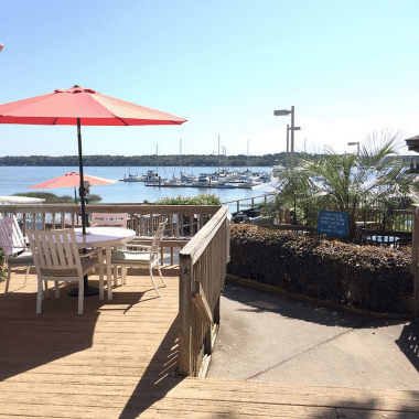
Good news about so little debris in the Waterway. Let’s hope it stays that way. Harborwalk Marina, A SALTY SOUTHEAST CRUISERS’ NET SPONSOR! is the northwesternmost marina on the downtown Georgetown/Sampit River waterfront.
Harborwalk Marina Left Osprey and headed down the ICW, water was extremely high, up to 4 or 5 ft above normal high tide. Surprisingly we did not run into a lot of debris on way to Georgetown, just took it slow and watched for any objects on the water. No problems at all. Again Georgetown is a good place to stop. All the shops are within walking distance and all are interesting to visit, not to mention all the good food. The crew here at Harborwalk as always are great. Phil and Sandy Herl
With the current weather conditions, this is almost adding insult to injury to Waterway cruisers. HOWEVER, high water wake damage can be severe, not only to docks, but to onshore buildings as well. So slow down in those populus docked areas along the Waterway. A SALTY SOUTHEAST CRUISERS’ NET SPONSOR!, Downtown Marina is located north of AICW marker #239, a short distance west of the Lady’s Island swing bridge, in the heart of downtown Beaufort.
Beaufort, SC Writing No Wake Tickets Be careful passing Beaufort, SC downtown docks. The police have a patrol boat tied up hidden in the marina and they are issuing no wake tickets to boaters. Dave Bell
The no wake zone that extends from Beaufort Marina South to the next bridge has been extended by two more no wake signs about a mile further South. The Beaufort no wake zone is already ridiculous but these new markers are at least half a mile from shore with no docks, wharfs or piers visible. What is the legality of these markers?
Osprey Marina lies at the southern foot of AICW section known officially as the Pine Island Cut (a. k. a. “the Rock Pile”), just as the Waterway sweeps south into beautiful Waccamaw River. Osprey Marina is one of the finest marinas you will ever discover, and these good folks are A SALTY SOUTHEAST CRUISERS’ NET SPONSOR!
Osprey Marina Arrived for fuel and to get tucked in for the weekend or until the circulation in the Atlantic has cleared the area. Topped off the tanks and while just holding the nozzle was talking to Miles. We both have the gout word in common. Once we were fueled and docked Miles said he would drive us to the clinic so I could get some medication. Thank You, Thank You Miles. I think I’m on the mend. As always Osprey has been great taking care of us. Day three and the rain is still falling in large quantities. So to pass the morning we gather for free coffee and snacks and conversation. Watching the bad weather shifting south, not good for anyone traveling south. I think we will stay a while longer. 10/5/15 Monday. It is Monday and all the water is high, so anyone between Southport area and Charleston area, if you are in a spot you can stay, stay where you are it is not safe on the ICW with all the trash floating in the water. Be safe. We are talking to others in the Marina and we are all staying put for now. Phil and Sandy Herl
The intersection of the ICW and Lockwoods Folly has been a Problem Stretch for years and requires almost annual dredging. Mid to high tide is recommended for passage. For a recent report on Lockwoods Folly, see /?p=150841. A SALTY SOUTHEAST CRUISERS’ NET SPONSOR! Myrtle Beach Yacht Club on Coquina Harbor has been a great stopping place and a friend to cruisers for years. The entrance to Coquina Harbor lies on the north side of the Waterway opposite Marker #13.
North Myrtle Beach
Another good run and luck is still with us. As we approached Lockwoods Folly area, notorious for shoaling, there was a Coast Guard boat at the spot getting ready to move the buoys. When we came through they contacted us and several others to talk everyone through and we had not a problem. As usual at North Myrtle Beach Yacht Club we were treated well. Again we could not do anything because of my foot. Just one night. We were here in June and had a great time.
Good music and good fun! Y’all come! Beaufort is home to SALTY SOUTHEAST CRUISERS’ NET SPONSOR, Downtown Marina of Beaufort, within easy walking distance of the Waterfront Park.
Please come and join us at Pickin’ by the River on October 17 from noon till 5 at Downtown Beaufort SC Henry C Chambers beautiful Waterfront Park. All acoustic bluegrass, country and folk music. Stage show and open jams throughout the Park. Please no amplifiers, alcohol or drums. Good family fun. For more info you can call (843)379-9084
Skipper Winter does indeed complement an earlier posting by Jim and Peg Healy, /?p=138583. Our thanks to John and Sue for this detailed narrative of their recent trip upriver to Conway. The upper portion of the Waccamaw River departs the Waterway at statute mile 375.
To hopefully complement Sanctuary’s posting, we just finished going to Conway and made the following notes. One can take these and mark the Healy’s maps, and add milage to them. the distances are not off more than a tenth at each junction: From ICW MM 375 just south of ICW marker `27A’: This is the last posting on any web sites that I have seen with any detail. We traveled this river this week and it is still a beautiful trip and well worth the extra time. It is even more beautiful than the lower Waccamaw. First, the Corps of Engineers have removed all markers above `R4’, and as such, there are a few spots that are confusing as to where to turn. Lastly, different postings on various web states the distance to downtown Conway anywhere from 12 to 16 miles without stating whether they are nautical or statute miles. Reset your odometer to `0’ for the following information. We use statute miles. From `G1’, the entrance marker, it is 14.3 miles to the last bridge (you do not want to go under that in a larger boat) and about 14 miles to the marina entrance basin. Just as Sanctuary recommends, go to the bridge to dock since it is an easy walk to town. The two floating docks are in decent shape, but the cleats are still a little loose, but there is no traffic or winds to bother you and if there was a huge blow, there are alternatives to tie up soundly ‘“ easy. The electric is still there but still no water. Call the marina for space (room for a 60′ boat at each dock, maybe longer). Also, repeating, when going into a curve, stay to the outside where the water is deeper. We entered at dead low tide (on purpose) so as to make better notes. The NOAA charts that end just above `R4’ are accurate. We saw 11-13′ at `G1’ and then before the first curve, 7.9′. After the first curve, it deepened to 9.0′ Just prior to the second curve, briefly 5.9′, but we were too much inside on the curve. Coming back down, we had over 7.5′. Hug `R2’. First curve after `R2’ was 8.3′. From here you will see depths well over 20′ in places. Just prior to `G3’, which is 1.9 miles in, 6.5′ and quickly deepens to 30’. MM 2.1 you’ll see many stumps on the RDB, but 8.1 feet as charted. MM 3.0 (`R4’) stay left at these intersections. MM 4.3, there are power lines that we do not know the height, but any motor boat will have no problems, but sailboats may (this statement applies to all power lines mentioned). They all appear to be well over 45′, but who knows. MM 4.7 at a private dock, make a left turn (it’s not obvious). MM 5.2 shallows to 8.6′ briefly. At MM 5.9, make a sharp left. MM 6.1, there are some nice homes to see, watch your wake. MM 6.9, favor RDB (starboard) for deeper water (7.5′, otherwise 6.0′). MM 7.6 some more homes. MM 9.4 is interesting. There is an upside down arrow sign that has the word `only’ upside down on it. Do not think this sign is upside down, it’s not. Whoever put it up, obviously did not have the correct sign. Make a sharp left here (yes, to port). If you go right, you hit bottom (we know ‘“ LOL). MM 10.0, another left turn where there is yet another upside down `only’ sign. MM 10.4-11.0, shallows to 7.4′ (this is where the river gets a little wider, so it makes sense the water would be shallower). MM 11.1 favor RDB where you get over 11′. Center is as low as 5.2’. MM 11.6, turn left. MM 12.1 is 6.6′ and there might be a very interesting river boat moored there. MM12.3, turn left at homes and docks. MM 13.2, overhead power lines. As you get to a high bridge, you are entering Conway. From here on in, it is no wake. You will see to your left the entrance to the marina basin around MM 13.9. Go past this to the floating docks on your left. They are obvious, just before the bridge. Call the marina for docking, but if no answer, don’t panic. If you are there just for a few hours, docking is free. The river walk is beautiful, and many great places to eat and shop. See the college (Coastal Carolina) ‘“ it is also very nice. One could easily stay here for a few days, so if the weather is not so good, and you have stopped at Georgetown enough, then this is the place for you. It takes about 2.5 hours (max) to do the river one way on a trawler. Sue and John Winter on Just Relax (MTOA, Golden Loopers, AIWA members)
Port Royal Landing Marina, A SALTY SOUTHEAST CRUISERS’ NET SPONSOR, is a perfect example of true Southern hospitality and of a marina family that cares about boaters! Port Royal Landing Marina guards the western banks of Beaufort River just south of marker #244.
Port Royal Landing Marina welcomes you and your crew! The delightful hospitality that you find in the Low Country of South Carolina is often referred to as “The Royal Treatment” here at Port Royal Landing Marina. Our staff is available and anxious to do everything we can to exceed your expectations of quality and service. It is our goal to make your stay at PRLM the most pleasant marina experience you have on your trip. We intend to be the standard by which you judge all other marinas along the waterway. CLICK HERE for a video introduction to Port Royal Landing Marina.
Royal Treatment Slow down, sit back, and relax. Stay another day or two. Enjoy the surrounding historic area, our facilities, and our service. Take advantage of our location between the two historic towns of Beaufort and Port Royal. Get a large dose of that Low Country “Royal Treatment” and we believe you too will find us habit forming! Problems? Let one of our knowledgeable staff members help. We can’t solve them all, but when we cannot, we will make every effort to find someone who can. CLICK HERE for bios of the Port Royal Landing Marina Staff
Historic Port Royal and Beaufort When berthed at our marina, you are surrounded by history. Jean Ribaut sailed into the Port Royal Sound in 1562 and wrote to his sponsors in France that there was “no fairer no fitter place.” His way of saying “it just doesn’t get any better than this.” He liked the area enough that he established the village of Port Royal that same year. Beaufort is a relative newcomer, chartered much later in 1711. Today, these two historic towns are separated only by the width of a sign post at the Burger King on Ribaut Road, which runs through both towns. This entire area is known for some of the finest hospitality in the South. We will be glad to make dinner reservations for you or to provide information on any of the many attractions in our area. There are many magnificent antebellum homes along the water and on Bay Street in downtown Beaufort- some of which are open to the public, such as the John Mark Verdier House. Even those that are not open to the public are still worth a trip by foot, bicycle, tour bus, horse drawn carriage, or our courtesy car to take a look at their magnificent pre-civil war construction. The area, and specifically some of these homes, has been host to a number of award-winning movies such as Forrest Gump, The Big Chill, The Prince of Tides, and The Great Santini (The last two were written by local author Pat Conroy). In fact, in the closing scene of The Prince of Tides, our marina can be seen as Nick Nolte rides over the adjacent bridge. In addition to the antebellum homes, there are several pre-civil war churches, the Beaufort Museum, fine antique stores, horse and buggy rides in the downtown area, tabby ruins at Old Sheldon Church and Dataw Island. Beaufort also features Hunting Island State Park, Parris Island, and the Penn Center, where the native Gullah traditions and language are preserved and nurtured. We will be glad to give you directions, provide you with maps, lend you the courtesy car, or drive you downtown to get started.
On-site Facilities: Ship’s Store– Located landside, you will find our ship’s store stocked with many marine items that you may need. We are a Land-N-Sea overnight order center. Should we not have what you need in stock, our 25,000+ item catalog probably does. Orders in by 3:00 PM are delivered around noon the next day with no freight charge to you. Deliveries are made Tuesday through Friday. Courtesy Car– The marina has a courtesy car available for your convenience. It is available for short trips in the area during normal marina hours. ATM machines, grocery stores, pharmacies, auto parts stores, medical facilities, banks, churches, golf courses, and shopping in downtown Beaufort or Port Royal are all just a short ride from the marina. We can provide you with a map and directions to any of these locations. Dock Carts– For ease in moving those supplies up and down our pier and docks, we have available a number of dock carts for your use. Also, if you need some additional hauling power, we can help with one of our golf carts. Just let us know! Shower and Restroom Facilities– Clean, code secured, well-lit showers and restroom facilities are located adjacent to the ship’s store. Detergent, toothbrushes, toothpaste, soap and other toilet articles are available in the ship’s store for purchase. Laundromat– We have an on-site laundry facility open twenty four hours for your convenience. The Back Porch Grille– Also landside, you will find the Back Porch Grille, our own little taste of waterway America. They serve what according to many of our repeat customers is the best cheeseburger on the ICW. A menu is included in your welcome package and we hope that you will give it a try. A ten percent discount is available for our visiting boaters. There is usually live entertainment on Friday and Saturday nights. The food is good, the service fair, the beverages cold, and the clientele… well, they are a study in themselves. The Back Porch Grille opens daily at 11:00 AM (opens at 4:00 PM on Mondays) and the food is available until 9:00 PM (or later with notice.) The bar closes around midnight, and it can be an adventure. Stop in and give it a try. Thank you for staying with us, best wishes, and safe passage. Please let us know what you have seen along the waterway that we might use to improve your next stay. Just a walk or short bike ride away:
Food & Beverage .4 miles………….Hardee’s: breakfast, burgers, sandwiches and fried chicken .5 miles………….Agave: Mexican grill (authentic Mexican cuisine) .6 miles………….Piggly Wiggly: grocery store .6 miles………….ABC Wine & Spirits: beer, liquor and wine .45 miles……….Alvin Ord’s: fresh made sandwiches and taco salads, etc. .45 miles……….CJ Seafood Express: fresh seafood market (shrimp, fish, crab, etc.)
Cypress Wetlands Boardwalk
.76 miles……….Mizu Japanese Restaurant: hibachi steakhouse and sushi .7 miles………….Port Royal Farmers Market: local produce and various fresh foods. Saturdays 8-12pm .8 miles………….Pizza Hut: dine in and delivery pizza .9 miles………….Carolina Tavern: wings & ribs sports bar 1.6 miles……….Smokin Planks: family owned and operated BBQ and Smokehouse 1.6 miles……… 4 Island Pizza: take out & delivery only 1.9 miles……….La Nopalera Restaurant: Mexican food 1.1 miles……….Red Rooster Café: breakfast & lunch meals Monday through Saturday 1.7 miles……….11th Street Dockside Seafood Restaurant: overlooking shrimp docks on Port Royal Sound 1.9 miles……….Moon Doggies Café & Grill: great American food meets Southern hospitality 1.9 miles……….Athenian Gardens: authentic Greek dishes with American friendly options 1.9 miles……….City Java: local coffee shop, breakfast & lunch 2.7 miles……….Publix: grocery store 2.8 miles……….Rancho Grande restaurant: Mexican food 2.8 miles……….Island Meat Market: Family owned market with full selection of prime cut meats 2.8 miles……….Bill’s Liquor: great selection of craft beer, premium liquor and fine wines Medical Care & Pharmacy .4 miles.………..CVS Pharmacy .4 miles………….Doctor’s Care Medical Facility .8 miles………….US Naval Hospital 1.7 miles………..Keyserling Cancer Center 1.85 miles………Dentists & Family Doctors, etc. 1.9 miles………..Beaufort Memorial Hospital Other Businesses & Services .4 miles…………Citgo Service Station .4 miles…………Advance Auto Parts .5 miles…………Ferguson Enterprises: plumbing, bath, kitchen & lighting .6 miles…………West Marine .6 miles…………MCAS Credit Union & ATM .6 miles………..Music Cooperative: Instrument sales, service and lessons .75 miles………CAPA’s Closet: thrift store benefiting abused children and child abuse prevention 1 mile…………..Roy’s Aquarium: pets & supplies 2.8 miles………Grayco Hardware & Home: family owned hardware and home goods store
Thank you for staying with us, best wishes, and safe passage. Please let us know what you have seen along the waterway that we might use to improve your next stay.
CLICK HERE for a feature on Pat Conroy’s 69ft yacht, The Prince of Tides
Don’t confuse Barefoot Marina, A SALTY SOUTHEAST CRUISERS’ NET SPONSOR!, with Barefoot Landing Transient Dock, which is located on the eastern (ocean) side of the AICW in Myrtle Beach, while Barefoot Marina guards the western banks.
9/11/15 My husband and I cruised icw from south harbor marina to barefoot marina for our first adventure on the icw. Upon our arrival at barefoot; we informed the dock master that my husband could use some assistance in docking due to being partially disabled from a stroke 6 years ago. They were more than welcome to accommodate us and assist us in anyway possible upon arrival and departure and our entire stay. They are definitely a must stop on your travels. MOST definitely we will be returning to barefoot on our next adventure. Thanks so much to Barefoot Marina for a Great first experience!!! Joe Miller
Abandoned boats is an issue not limited to the Florida Keys – see a recent article on the Florida issue, /?p=150203. Charleston has been fighting the same problem for years and the headline below “finally clearing” has been published in our local Post and Courier a number of times in the past. However, our thanks to writer Diane Knich for posting this article, because it is certainly good news for cruisers who choose to anchor in the Ashley. These popular anchorages are acoss the river from SALTY SOUTHEAST CRUISERS’ NET SPONSOR, City Marina.
City finally clearing old, abandoned boats from Ashley River Diane Knich Email @dianeknich Aug 31 2015 5:44 pm Aug 31 7:18 pm
A battered and barnacled 25-foot sailboat dangled from a crane on the edge of the Ashley River near the gateway to the peninsula on Monday.
It was the first abandoned boat a contractor hired by the city pulled from the water using a $104,000 grant from the state’s Department of Health and Environmental Control, which included $75,000 in federal funds from the National Oceanic and Atmospheric Administration. The city of Charleston also contributed $30,00 in matching funds.
Boats that for years have been lying in the pluff mud in the Ashley River are being removed by Salmon’s Dredging, including this 28-foot sailboat that dangled from a crane on the barge. Enlarge’ƒBoats that for years have been lying in the pluff mud in the Ashley River are being removed by Salmon’s Dredging, including this 28-foot sailboat that dangled from a crane on the barge. Grace Beahm/Staff The boat for years had been lying on its side in the pluff mud near the U.S. Highway 17 bridge, said Sgt. Chad Womack with the Charleston Police Department’s Harbor Patrol.
Womack spends his days on the water, and knows the story of many of the abandoned and derelict boats clogging the river and causing navigation and safety hazards for other boats.
A man lived on that sailboat for 10 years, Womack said, but about three years ago he apparently fell overboard and died. His body was found in the water near Charles Towne Landing.
Womack said most abandoned boats are found in a mile-long stretch between the West Ashley bridges and the Intracoastal Waterway. He has estimated there are about 15 boats out there ranging in size from 23 to 40 feet.
He hopes to use the grant money to remove about 10 of them. But it depends on how many contractor Salmon’s Dredging can get with the money. It’s hard to know how complicated and time-consuming each boat will be until workers begin to try to remove them.
`Some of them just float by miracles,’ said Patrick French, an officer with the Harbor Patrol. `They look structurally sound, but when you bring them up, they disintegrate.’
Womack said Salmon’s is `going to go for the visible stuff first.’ Then they might try to remove some of the boats that already have sunk.
On Monday, employees were working from a barge to remove three other boats near the sailboat: a 28-foot sailboat, a 35-foot Bayliner motorboat and an old houseboat.
Womack said the police do all they can to find out who owns the boats before they use grant money to remove them. It’s an owner’s responsibility to pull a boat out of the water, he said. `And we pursue people criminally for abandoning boats.’
But it’s often impossible to figure out who owns the boats. The law requires boats to be registered, but the registration of many boats that show up in the river isn’t up to date.
Womack doesn’t know how long it will take Salmon’s to remove the boats. But the company will take them to land it owns on Shipyard Creek and dismantle them, he said. There’s nothing to salvage from old abandoned boats. `They’ll destroy them and take them to the landfill.’
Reach Diane Knich at 937-5491 or on Twitter at @dianeknich.
Womack “knows the stories” of many of the vessels ,The law requires all vessels registeted,yet it’s a big.mystery who is responsible? Who is being paid to patrol the waterway? Apparently,theyre too busy to address the unregistered boats as they arrive in their juristiction? Must be too busy doing “safety” boardings of obviously seaworthy transients to bother with improperly ,obciously derelict vessels that are clesrly incapable of navigation,are improperly anchored and without proper lighting. The “autgorities” could focus on the problems before they become abandoned or sink and these monies could be put to better use. Instead of letting it go for months and years,as they pass by them on their way to approach vessels underway.
We get a lot of requests for assistance on various aspects of boating and navigation, but this question is certainly one for the books. So come on all you noble Southern Sausage Chefs, lets hear your method of cooking the famous Bucksport Sausage! Bucksport Marina, A SALTY SOUTHEAST CRUISERS NET SPONSOR, is located south of Waterway marker #36, along the western shores of the beautiful Waccamaw River.
My son Jeff Meyer brought me a Bucksport sausage and I have never seen one like it before. I have no idea how to cook it. Where can I find directions, I need help. June Dienes
Moving upstream from Winyah Bay, Hazzard Marine is the first facility cruisers will encounter on the downtown, Sampit River Georgetown waterfront. This facility was rebuilt several years ago and now, as Skippers Bill and Devon attest, is a far cry from the forgettable fishing craft dock that once it was.
Hazzard Marine is one of the best most friendly marinas my wife and I have ever stopped at! We were on our way from Carolina Beach NC to the Excuma islands in the Bahamas when we had some unexpected boat problems. Hazzard Marine was the closes marina with a travel lift so we limped on in not knowing anybody there or having reservations. WOW is all I can say!! the folks there we so helpful and friendly. The entire staff helped with all the repairs/rental cars/meal suggestions/shipping of repair parts,etc etc. After 5 days there we hated to leave and move on. The prices are reasonable and the marina is very well kept. GREAT PLACE FOR A LAYOVER/WEEKENDER/OR JUST TO MEET THESE WONDERFUL FOLKS. Bill and Devon `WIDEOPEN’
This article by Prentiss Findlay in Charleston’s Post and Courier is a follow up to his earlier piece on much needed dredging in the Isle of Palms area of the Waterway, /?p=149544.
Army Corps: Crucial McClellanville, Breach Inlet dredging in works for Intracoastal Waterway Prentiss Findlay Aug 23 2015 12:01 am Jeremy Creek in McClellanville will likely be dredged after the Army Corps of Engineers announces the details of a contract in a few weeks.
The picturesque, historic village of McClellanville, which depends on Jeremy Creek for its commercial fishing livelihood, is facing a crisis because the tributary is in such bad shape.
`Our creek is just a disaster right now, frankly. Some of these extra low tides, the sides of the creek are almost touching. The bigger boats can hardly move at all except from half-tide up,’ Mayor Rutledge Leland said.
The Breach Inlet bridge links Sullivan’s Island (right) and the Isle of Palms. Enlarge’ƒThe Breach Inlet bridge links Sullivan’s Island (right) and the Isle of Palms. File/Staff `Beyond critical’ was how he described creek conditions.
`It’s reached an emergency situation,’ he said.
But help could be on the way, he said.
Leland said he came away from a recent meeting with Army Corps of Engineers officials optimistic that the town would see its share of $2.4 million recently awarded to the Corps Charleston District for Intracoastal Waterway dredging. The creek is considered part of the waterway.
`It was very good news. I left there feeling very good. It sounds like we are going to be a part of the package and it will just be a matter of time before they (Corps) are here. Probably November or December before we see a dredge here,’ Leland said.
The Corps’ top priority for waterway dredging in this area has been identified as the stretch from Isle of Palms Connector to Ben Sawyer Bridge, particularly in the area of Breach Inlet between IOP and Sullivan’s Island.
The waterway condition in that area has caused the IOP Marina to take a big hit financially. Boaters go offshore and re-enter the waterway at Charleston Harbor because the local stretch has acquired a reputation as one of the worst areas of the Intracoastal from Virginia to Florida, officials said.
In 2013, a Mount Pleasant woman was injured on the waterway near the inlet when a 44-foot trawler drawing 3 feet 10 inches of water hit bottom. The impact caused her to fall. In the emergency room, doctors determined she had a fractured vertebrae, a concussion and a broken rib. She spent two nights in the hospital, officials said.
On Thursday, Corps officials said that McClellanville could benefit from the latest round of federal funding for waterway dredging in this area. Charleston County has agreed to contribute another $500,000 to the cause, which would bring the total available for waterway channel maintenance to about $3 million. First, though, the federal government must agree to accept the county funds, officials said.
Corps officials said two companies bid for Intracoastal dredging here, and there is an apparent low bidder. Corps Charleston District spokeswoman Glenn Jeffries said she could not discuss specifics of the project without putting it in jeopardy. Details will be finalized in the first week or two of September, officials said.
`Until the contract is awarded, we really can’t say the price, we really can’t say exactly what work will be accomplished, but based on the (bid) opening, there is a better than average chance that we will get to do something in McClellanville,’ said Brian Williams, who is the Corps district chief for programs and civil projects.
Leland said the creek was last dredged about 10 years ago. The tributary was created from mud flats as part of the original waterway project, he said.
When the tide comes in, the mile-long creek that leads to McClellanville’s two seafood processing plants is passable for the big boats, but even then conditions are not ideal.
`It pretty much has to be on the (high) tide, but it’s getting to be more of a struggle every day,’ Leland said.
How much the problem is costing the town has not been determined, he said, but one study showed that McClellanville-based commercial fishing pumps millions into the economy, he said.
The last substantial funding the Army Corps received for waterway dredging was in 2009 through the American Recovery and Reinvestment Act. Some states, such as Florida and North Carolina, have dedicated funding for waterway maintenance. The Florida Inland Navigation District collects about $20 million annually to pay for waterway maintenance in 12 counties. North Carolina funds waterway maintenance through boater registration fees and the gas tax.
For now, trawlers push their way through shallow water in Jeremy Creek. At low tide, the creek is a muddy mess that idles many boats for long stretches of the day, Leland said.
`The only thing that is keeping it (creek) open now is the (boat) traffic. They’re stirring the mud up. The (Army) Corps calls it ‘˜agitation dredging.’ That’s the only reason we have any water at all right now,’ he said.
Reach Prentiss Findlay at 937-5711 or Twitter.com/prentissfindlay.
School is in session for all ages and all places, even islands! But this “school bus” is one you may not know about, so Watch Your Wake! Sandy Island is the name of a small unincorporated community in Georgetown County, South Carolina. This article by Erin MacPherson is from WPDE.com.
New Sandy Island School Bus Boat
New Sandy Island School Bus Boat
Sandy Island gets new school bus boat by Erin MacPherson Posted: 08.05.2015 at 6:11 PM For years, the Sandy Island community and Georgetown County School officials have wanted a new school boat to get students who live on the island to and from school. The boat they were using was from 1964. And now, they have a new one. “It transports students just like a bus from Sandy Island to the mainland and then we put them on a bus and take them to school,” said Dr. Randy Dozier, Georgetown County Superintendent. The New Prince Washington is the state’s only school boat. Dr. Dozier says the boat they used before this one was outdated. “It was fairly slow, not as accessible and harder to operate. We wanted to bring it up to speed and make it safer more modern. Now we have a boat specifically for that and it’s brand new,” said Dozier. Dozier says the school board understood how important this boat is for the students on Sandy Island. “I have ridden on the old boat; it’s not a satisfactory trip. It’s a safe trip but it’s just crowded and old. This new boat is so much better and I can’t wait to ride on it,” said Richard Kerr, a trustee with the Georgetown County School Board. But getting this new boat wasn’t an easy task. Dozier says it’s all thanks to State Superintendent Molly Spearman. “This is owned by the state department much like a school bus. They maintain it. We provide the pilot, they provide the base salary, and we supplement that,” said Dozier. Tuesday, the boat passed the Coast Guard’s inspection. It seats 12 people, has a place for the pilot and co-pilot, and it has tie downs for wheelchairs. Dozier says it can safely fit 16 people and has plenty of life jackets for all passengers. “It looks great and meets all specifications,” said Dozier. The New Prince Washington will have its first launch on the first day of school. There’s no word yet on what they’re going to do with the old school boat.
Because of The Spirit of South Carolina, built by hundreds of volunteers and based in Charleston, tall ships are of particular interest to Charlestonians. One will not be surprised to learn of an invitation to visit Charleston being extended to Oliver Hazard Perry in the near future.
Maiden Voyage: SSV Oliver Hazard Perry Sets Sail NEWPORT, RI (July 17, 2015) ‘“ Rhode Island’s 200-foot Official Sailing Education Vessel SSV Oliver Hazard Perry sailed for the first time yesterday in Narragansett Bay after she left the Hinckley Boat Yard in Portsmouth, R.I. to begin a journey up the coast to join the Tall Ships Portland 2015 festival. Anyone on or near East Bay Passage between seven and eight a.m. saw a truly amazing spectacle when four of the ship’s 20 sails were unfurled, one-by-one as crew members climbed aloft to set free the lines that secured them to the yards.
Rhode Island’s 200-foot Official Sailing Education Vessel SSV Oliver Hazard Perry sailed for the first time yesterday in Narragansett Bay. (All photos credit Onne van der Wal)
Rhode Island’s 200-foot Official Sailing Education Vessel SSV Oliver Hazard Perry sailed for the first time yesterday in Narragansett Bay. (All photos credit Onne van der Wal) Available for download in high resolution by clicking the photo
`This is a huge milestone,’ said Jess Wurzbacher, Executive Director of the non-profit Oliver Hazard Perry Rhode Island (OHPRI), `over the past seven years all of her movements have been under the control of tugs. The wind was blowing 12-15 knots out of the north to make it a nice downwind run out of the Bay, so it was great to watch the sails harness some of that power ‘“ it is what we have all been waiting to see for years.’
SSV Oliver Hazard Perry is the first ocean-going full-rigged ship built in America in over a century. She also is this country’s largest privately-funded, actively sailing Tall Ship, one of only 75 Tall Ships in the world designated by Sail Training International as Class A.
On July 3rd SSV Oliver Hazard Perry was dockside at the Newport Shipyard for the `Homeport Rhode Island’ gala. The annual fundraising event celebrated the unprecedented $16 million economic development project, which has supported hundreds of jobs in the Rhode Island marine industry. It raised $122,000 while also honoring the non-profit organization’s Board Chairman Bart Dunbar for his unfailing devotion to OHPRI’s Education-at-Sea mission.
cid:image003.jpg@01D0C0A0.EEAE3900 Supporters gathered at Newport Shipyard for Oliver Hazard Perry Rhode Island’s `Homeport Rhode Island’ Gala on Friday, July 3. (All photos credit Al Weems, alweemsphoto.com) Available for download in high resolution by clicking the photo
With orange being the color theme, most of the 450 guests were decked out in their orange best. The signature drink, the `Dunbar Fizz,’ also was orange, and wait staff from Blackstone Catering sported orange bow ties. Cocktail hour included tours of the ship, passed hors d’oeuvres and offerings from a fresh seafood bar, while dinner was served under a giant tent with orange globe lights.
At the event, Dunbar acknowledged all of OHPRI’s supporters, and especially Admiral Tom Weschler, OHPRI’s Chairman Emeritus, who was in attendance, with helping the organization realize its dreams. `We are far from finished with fundraising,’ said Dunbar, explaining that the focus will soon turn to the ship’s Education at Sea programs, `but it is a huge milestone to have the ship completed and going through its final inspections and preparations for accommodating students of all ages.’
Rhode Island’s Tall Ship will serve the youth from all states with its Education at Sea programs. It is the first ocean-going full-rigged ship built in America in over a century.
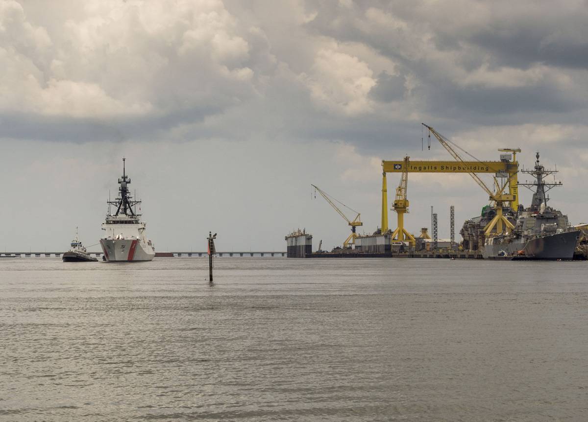
South Carolina is proud to have the National Security Cutter James make Charleston her home port. NSC 5 is named to honor Capt. Joshua James, one of the world’s most celebrated lifesavers.
USCG’s New Cutter Sails from Ingalls Posted by Eric Haun Thursday, July 16, 2015
The National Security Cutter James (WMSL 754) sails away from Ingalls Shipbuilding. (Photo: Lance Davis/HII)
The National Security Cutter James (WMSL 754) sailed away from Huntington Ingalls Industries’ (HII) Ingalls Shipbuilding division on Sunday, July 12, one month after being delivered to the U.S. Coast Guard, HII announced. The new built vessel James will be commissioned on August 8 in Boston before heading to Charleston, S.C., where she will be stationed alongside Ingalls’ fourth NSC, Hamilton (WMSL 753).
“James is an excellent ship and another example of the outstanding work accomplished by our shipbuilders,” said NSC Program Manager Derek Murphy. “Through serial production in this program, each successive ship continues to come down the learning curve. The quality remains world-class, as proven by the substantial reduction in the number of trial cards with each successive ship in the class. Ingalls shipbuilders have once again delivered an NSC that will continue to protect our nation for the next 40 years.”
Skipper Lattimer poses questions that have asked many, many times over the years. See /?p=89755 and /?p=143206 for comments from other boaters. As to precedents for openings, emergency vehicles and vessels get priority. On weekends, it is normally water traffic that is heavy and the On Demand must restricted to openings every 15 minutes. During weekday rush hours, the opposite is true. And, as I understand from conversations with the bridge tenders, the old swing bridge roadway still serves a nearby school zone, requiring that waterway traffic be restricted for school buses. It is a tough job for the tenders who must rely on their on-the-spot judgement to apply restrictions.
Re: Socastee swing bridg . What do you mean `Opens on Demand’ Demand from who? Also, how many boats are considered heavy vessel traffic? It’s not unusual to have a hundred, probably a lot more, cars and trucks tied up when the bridge is open to `some’ boats. Which should take precedence? Ed Lattimer
What should take precedence, Ed, is the USCG-approved status of the bridge. The Socastee Bridge is NOT restricted, so by definition, it is “on request”/”on demand.” The “requestor”/”demander” is the pilot of the boat. Having transited the ICW on many fall/spring migrations, I have experienced all of the ICW bridges. At Socastee, I have had excellent service and terrible, disrespectful service. The bridge is unreliable, at best. The bridge operations staff is made up of people who believe in serving the needs of boaters and people who do not. The argument of emergency vehicle traffic or school bus traffic applies to every bridge everywhere. There is absolutely nothing unique to Socastee. The bridge – and the city that owns the bridge – should honor it’s commitments to waterway users. Honor them or change them, but none of this, “it’ll be about 15 minutes or so before I can open” nonsensical stuff.
Finally!! But, sadly, not until October in the middle of the Fall Migration, as explained in this article by Prentiss Findlay in Charleston’s Post and Courier. A reminder that the tidal range in this area is 5+ feet, so high tide would give you 7+ feet. And, as in the past, we recommend HIGH TIDE ONLY through this stretch.
Corps has $2.4 million for Waterway dredging at IOP, Sullivan’s
A boat is shown stranded on a shoal in the Intracoastal Waterway. A local section of the waterway between Isle of Palms Connector and Ben Sawyer Bridge will be dredged to make marine travel easier. The federal government has appropriated $2.4 million for the project.
Some $2.4 million in federal funds has been authorized for dredging the Intracoastal Waterway between Ben Sawyer Bridge and the Isle of Palms Connector, officials said Thursday.
The section at Breach Inlet between Isle of Palms and Sullivan’s Island is only two feet deep at low tide. `It’s bad. It’s definitely bad,’ said Brian Berrigan, president of Isle of Palms Marina.
Work to dredge the channel is expected to begin in October, said Sean McBride, spokesman for the U.S. Army Corps of Engineers Charleston District.
`It’s our No. 1 priority,’ McBride said.
The waterway near Breach Inlet has been nearly dry at low tide because of shoaling, a condition in which sand builds up and blocks the channel. The authorized channel depth is 12 feet and the width is 90 feet.
Berrigan said word of the dredging is good news but only a temporary solution for a condition that is sure to happen again.
`We definitely need a long-term fix,’ he said.
Berrigan said transient boaters avoid the area because of the shoaling problem.
`It’s changing people’s schedules for sure,’ he said.
As a result, the marina has taken a tremendous hit financially. Diesel fuel sales are off 30 percent from last year, he said.
The City of Isle of Palms said the condition of the waterway has created safety concerns for boaters, particularly at low tide. `Boaters should use caution in this area until the dredging project can deepen the ICW,’ the city said.
The dredging is expected to be completed by the end of the year, the city said.
In the fall of 2013, a Mount Pleasant woman was injured on the waterway near the inlet when a 44-foot trawler drawing 3 feet 10 inches of water hit bottom. The impact caused her to fall backward and hit her head. In the emergency room, doctors determined she had a fractured vertebrae, a concussion and a broken rib. She spent two nights in the hospital.
Because of the low water, some boaters go offshore and re-enter the waterway at Charleston Harbor. The section of waterway has acquired a reputation as one of the worst areas from Virginia to Florida.
The last substantial funding the Army Corps received for waterway dredging was in 2009 through the American Recovery and Reinvestment Act.
Some states, such as Florida and North Carolina, have dedicated funding for waterway maintenance. The Florida Inland Navigation District collects about $20 million annually to pay for waterway maintenance in 12 counties. North Carolina funds waterway maintenance through boater registration fees and the gas tax.
Reach Prentiss Findlay at 937-5711 or Twitter.com/prentissfindlay.
The two Tom Point Creek anchorages are among the best south of Charleston, as a number of you have commented. Our thanks to Phil and Sandy Herl for this report.
Tom Point Creek We finally left Lady’s Island Marina, after one month enjoying every minute. And getting our pumps and cat food delivered. With a late start we had to stop and just wait for the tide at Ashepoo/Coosaw cut but that was no problem, we have no agenda. When we got through the cut we thought about St Johns Marina or the Isle of Palms too late for either. Both jam up and jelly tight, we stopped at Tom Point Creek for an overnight anchor. No problem, and we enjoy an anchor out as long as the gen keeps working, and it did. Started out first thing in the AM and was running too early for Leland Marina (low tide) so we just dropped an anchor and waited out the tide and came in with no problems. Just enjoying the trip. Phil and Sandy Herl
Myrtle Beach Yacht Club on Coquina Harbor has been a great stopping place and a friend to cruisers for years, as Skipper Herl reports. Naturally, they are A SALTY SOUTHEAST CRUISERS’ NET SPONSOR! The entrance to Coquina Harbor lies on the north side of the Waterway opposite Marker #13.
Myrtle Beach Yacht Club Arrived around 3:45 and melted into the dock. Been a long day, lots of slow going with a lot of no wakes. And it has been hot. Stopped at Osprey for fuel, best prices in the area, then continued to Myrtle Beach for the night. To hot to cook so we eat at Clarks, its right next to the marina. Every thing was excellent. Had a problem with the electric `Y’, had to get one ordered from West Marine. Had two days to enjoy the area, we rented a car and did just that. Found some fresh shrimp and did them on the Barbee. Then were able to find Fishy Fishy, had a fantastic meal. Great stay. Phil Herl
The South Channel of Charleston Harbor is essentially the Waterway as it runs east/west from the Ashley River to the Waterway’s eastern harbor entrance into Sullivans Island Narrows at ICW marker #130. There is plenty of water on either side of the harbor channel in which to avoid the dredge equipment. Project dates are not given.
SOUTH CAROLINA – CHARLESTON HARBOR SOUTH CHANNEL: Dredge Operations Mariners are requested to stay clear of the dredge, pipelines, barge, derricks and operating wires about the dredge. All operators should be aware that the dredge and pontoon lines are held in place by cables, which are attached to anchors some distance from the dredge and pontoons. Buoys are attached to the anchors so that they may be moved as the dredge moves. Submerged lines should be avoided. Mariners are requested to exercise extreme caution when approaching, passing, and leaving the dredging plant. The dredge LEXINGTON monitors VHF channels 13 and 16. Mariners arc cautioned to strictly comply with the Inland Rules of the Road when approaching, passing and leaving the area of operations, and remain a safe distance away from the dredge, booster, buoys, cables, pipeline, barges, derricks, wires and related equipment. Owners and lessees of fishnets, crabpots and other structures that may be in the vicinity and that may hinder the free navigation of attending vessels and equipment must remove these from the area where tugs, tenderboats and other attendant equipment will be navigating. Dredging operations will be conducted twenty-four (24) hours a day seven (7) days a week, all fishnets, crabpots and structures in the general area must be removed prior to commencement of any work, a slow NO WAKE speed is requested of transiting vessels. All vessels are requested to contact the dredge prior to passing. Chart 11518 and 11524 LNM: 25/15


Be the first to comment!