


CRUISERS NET
Cruisers Helping Cruisers
Comprehensive cruising resource for the Intracoastal Waterways
from Norfolk to the Northern Gulf and Bahamas.
from Norfolk to the Northern Gulf and Bahamas.
FREE to use due to the generosity of our sponsors - please patronize them
Offshore Nor’easter Unleashes Dangerous Marine and Coastal Conditions – Fred Pickhardt
Fred Pickhardt’s Substack is free today. But if you enjoyed this post, you can tell Fred Pickhardt’s Substack that their writing is valuable by pledging a future subscription. You won’t be charged unless they enable payments.

 Forwarded this email? Subscribe here for more
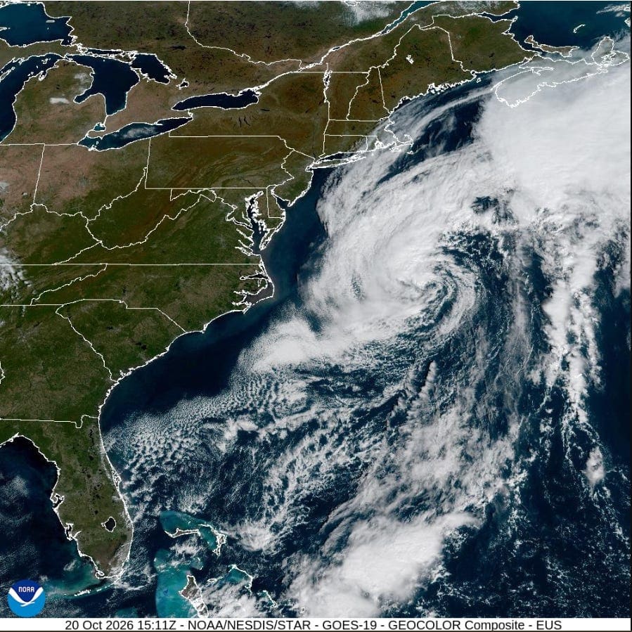
A potent atmospheric duo—combining a strong high-pressure system parked over the eastern United States and southeastern Canada with a developing offshore nor’easter is generating hazardous weather stretching from New England down through eastern Florida. Gale Warnings and Storm Warnings are in effect for offshore and coastal waters.
Gale Warnings & Coastal Hazards
A tight pressure gradient between the mainland high pressure and the offshore low-pressure system is driving northeast to north winds to 35-45 knots, with higher gusts offshore and 20-30 knots near the coast. As a result, Gale Warnings remain in effect for significant portions of the Mid-Atlantic and North Carolina coastal zones through at least Wednesday.
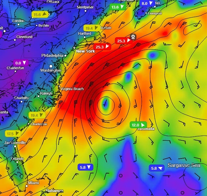
Coastal Hazards:
There is a high risk for dangerous rip currents from the Carolinas all the way down through parts of eastern Florida. Rough surf conditions, beach erosion, and coastal flooding are an ongoing concern.
Current Status
The center of the low pressure is located near 36N 70W (roughly 300 miles east of the North Carolina Outer Banks) with a central pressure of 1001 MB and is drifting slowly north to northeast.
Within 180 nautical miles (NM) of the west and northwest of the center, winds are 35 to 45 knots with higher gusts. Elsewhere west of a line spanning 31N 71W to 33N 66W to 43N 60W, sustained winds are 25 to 40 knots. Significant wave heights are 4 to 7 meters (13 to 23 feet) are occurring west of the center.
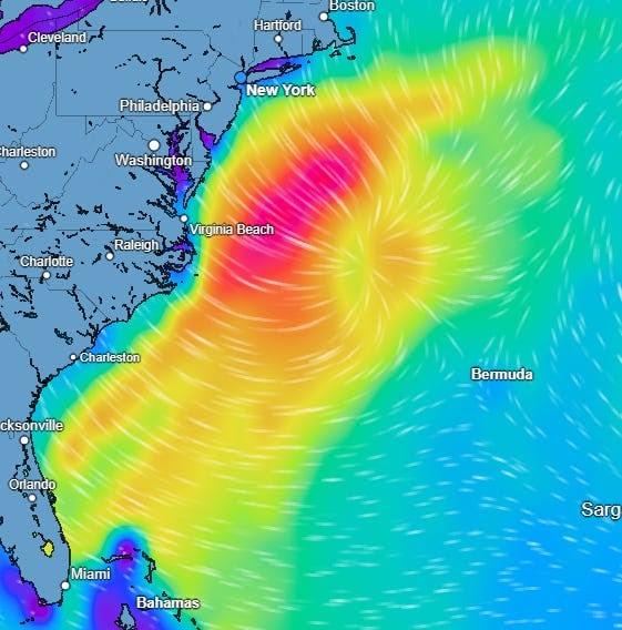
Current Wave Heights 13-23 feet offshore
18-24 Hour Forecast
The low is expected to deepen to 997 MB within 12 hours with winds increasing to 40 to 55 knots within the northwest semicircle and significant wave heights will build to 5.5 to 8 meters (18 to 26 feet).

Longer-Term
The low center will move northeast, however, it will remain over warm sea surface temperatures and there is a 40% chance that the system could transition into a sub-tropical storm.
Forensic Marine Weather Expert
NOAA National Hurricane Center
NOAA US Coastal Waters Forecasts
You’re currently a free subscriber to Fred Pickhardt’s Substack. For the full experience, upgrade your subscription.


© 2026 Fred Pickhardt
548 Market Street PMB 72296, San Francisco, CA 94104Be the first to comment!
Pumpkins, Stars & a Little Spooky Fun 🎃✨ – Elizabeth City
Elizabeth City sits at the southern terminus of the Dismal Swamp Canal and has the well-earned reputation of being a transient-friendly town with free dockage for 72 hours.
https://visitelizabethcity.com/
https://mailchi.mp/1d1a53af3ca3/pumpkins-stars-a-little-spooky-fun-4334578?e=f94c759194Be the first to comment!
City of Gulfport Celebrates Florida City Week, Gulfport, FL
The City of Gulfport and Gulfport Municipal Marina, A CRUISERS NET SPONSOR, always has a full calendar of events for all ages. The marina and harbor, found on the northern shores of Boca Ciega Bay, are easily accessible from the Western Florida ICW, just north of Tampa Bay.
City of Gulfport
Public Information Office
Gulfport, Florida
For Immediate Release
CITY OF GULFPORT CELEBRATES
FLORIDA CITY WEEK
October 19–25, 2026
The City of Gulfport is joining municipalities throughout the state in celebrating Florida City Week, October 19–25, 2026, a statewide initiative sponsored by the Florida League of Cities to raise awareness about the importance of municipal government and its daily impact on residents.
As the level of government closest to its residents, municipal government plays an essential role in providing public services, maintaining infrastructure, supporting public safety, and enhancing the quality of life within the community. Florida City Week provides an opportunity for residents to better understand how their local government operates, the services it provides, and the importance of community involvement.
“Local government is the government closest to the people, and it touches our daily lives in so many ways, from the streets we travel to the parks we enjoy. That’s why we hope every resident will take a moment to see how their city works,” said Vice Mayor Marlene Shaw. Throughout Florida City Week, the City of Gulfport encourages residents to learn more about the many departments, programs, and services available to the community. From public safety and infrastructure maintenance to recreational programming, cultural facilities, library services, and community development, City employees work every day to meet the needs of Gulfport residents.
Residents are encouraged to become more involved in their local government by exploring the City’s website, attending City Council meetings, participating in public discussions, and contacting City departments with questions, concerns, or suggestions.
“Florida City Week invites residents to learn about the many services our City provides and to reach out with ideas, take part, and ask questions. You may be surprised by how much your City does every day,” added Vice Mayor Shaw. Florida City Week is sponsored by the Florida League of Cities, the statewide association representing Florida’s municipal governments. The annual celebration promotes civic education, community engagement, and a greater understanding of the role municipal government plays in residents’ everyday lives.
For more information about City departments, services, and upcoming public meetings, visit:
City Website: https://mygulfport.us/
Main Phone: (727) 893-1000


Florida City Week – Florida League of Cities
Florida City Week Held annually in October, Florida City Week is a weeklong event when Florida’s cities celebrate, showcase, and engage citizens in the work of municipal government. Florida City Week is a time for municipalities to foster civics education, collaboration, volunteerism, and more. Read More 
City of Gulfport Florida | 2401 53rd Street South | Gulfport, FL 33707 US Be the first to comment!
AIWA Annual Meeting, Nov 17-19, 2026
Cruisers Net is proud to be a member of the Atlantic Intracoastal Waterway Association, whose lobbying work is crucial to keeping the Waterway navigable and safe. Your membership dollars directly support their vital work. Please join and encourage your boating neighbors to do the same, regardless of their home port.
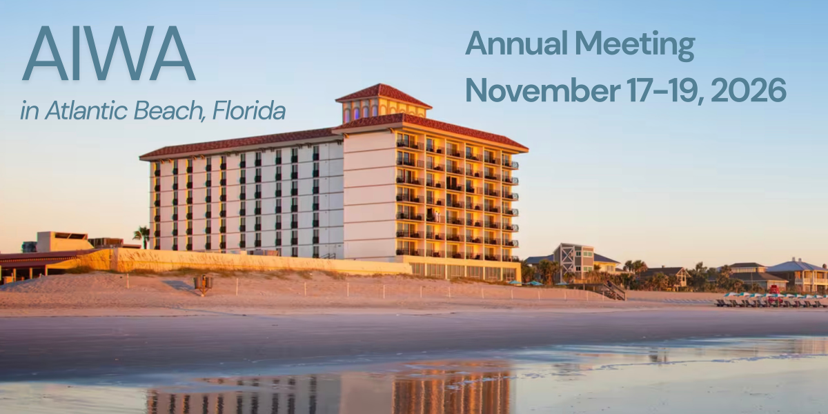
Early Registration Ends Today, October 19th The AIWA Annual Meeting is one month away! Join us to learn from distinguished speakers in the industry, and network with fellow waterway stakeholders.Early Registration Ends OCT 19:
 https://
atlanticintracoastal.org/2026- annual-meeting The program includes:
- State of the Waterway presentations of recently completed projects and upcoming projects for all USACE Districts along the waterway in 2027
- Updates from our federal partners at the U.S. Coast Guard, Maritime Administration and National Ocean Service
- A View from Washington, D.C. and the Waterway Access Initiative led by the National Marine Manufacturers Association
- A deep dive into beneficial use of sediment with success stories and emerging technologies
- Changes in Contracting for Federal Dredging Projects
- Emerging technologies and solutions
- and the kickoff event for Florida Inland Navigation District (FIND) 100th year in 2027!
Sponsor: Sponsorship opportunities are still available! Visit the conference webpage.
Hotel: Group rate of $294 per night (inclusive of all taxes + fees) ends today, October 19.
Visit booking link for the Dune House in Atlantic Beach, Florida. We look forward to welcoming you to Atlantic Beach, FL next month!
Brad Pickel, Executive Director
Atlantic Intracoastal Waterway Association
Members Notice
On November 18, 2026, the association will vote on a recommended change to the bylaws language related to the number of possible board members in Article 5, Section 3 as outlined below:The current language:
Section 3. At the Annual Meeting there shall be elected by ballot the Chair, Vice Chair, Treasurer and Secretary. The Board of Directors shall consist of no more than 15 members. At each Annual Meeting, one-half (or, one half plus one in the event of an odd number) of the Directors shall be elected for a term of two (2) years. Any Director shall be eligible for re-election provided they are representing members in good standing, or who are members in good standing themselves. Directors shall, upon election, immediately enter upon the performance of their duties and shall continue in office until their successors shall be duly elected and qualified unless they resign, are removed, or are otherwise unable to fulfill an unexpired term.The proposed language:
Section 3. At the Annual Meeting there shall be elected by ballot the Chair, Vice Chair, Treasurer and Secretary. The Board of Directors shall consist of no more than 17 members. At each Annual Meeting, one-half (or, one half plus one in the event of an odd number) of the Directors shall be elected for a term of two (2) years. Any Director shall be eligible for re-election provided they are representing members in good standing, or who are members in good standing themselves. Directors shall, upon election, immediately enter upon the performance of their duties and shall continue in office until their successors shall be duly elected and qualified unless they resign, are removed, or are otherwise unable to fulfill an unexpired term.


Copyright © 2026. Atlantic Intracoastal Waterway Association. All rights reserved. The AIWA is a national non-profit organization with the mission of securing funding and support for the maintenance of the Atlantic Intracoastal Waterway. We are the only organization dedicated to ensuring the future of the AIWW and proudly represent all stakeholders of the waterway.
Contact:
Atlantic Intracoastal Waterway Association
5a Market | Beaufort, SC 29906
(843) 379-1151 | atlanticintracoastal.orgWant to change how you receive these emails?
You can update your preferences or unsubscribe from this list.
Be the first to comment!
Cruisers’ Net Weekly Newsletter – October 16, 2026
Cruisers’ Net Newsletter for this week has just been emailed via Constant Contact.
If you want to view the newsletter but are not signed up to receive them automatically, you can view it at https://conta.cc/4yXFFja or see it below.
To automatically receive our emailed Fri Weekly Newsletter and Wed Fuel Report, click:Be the first to comment!
Navigating Gulf Weather during November – Fred Pickhardt
Fred Pickhardt’s Substack is free today. But if you enjoyed this post, you can tell Fred Pickhardt’s Substack that their writing is valuable by pledging a future subscription. You won’t be charged unless they enable payments.
Forwarded this email? Subscribe here for moreNavigating Gulf Weather during November
A Mariner’s Guide to Gulf Weather, Waves, and “Northers”
∙Preview


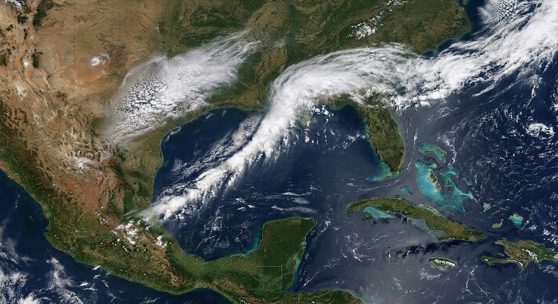
November brings a massive relief to Gulf mariners as tropical threats plunge—but it also ushers in a notorious structural hazard: the “Norther.” As late autumn settles across the US Gulf Coast, routing strategies completely shift from avoiding hurricanes to surviving punishing cross-sea conditions.
Whether you are hugging the Texas coastline or making a crossing toward the Yucatan, here is what you need to know about routing, sea states, and the arrival of the classic Gulf cold front.
Gulf Port Weather
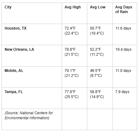
Coastal cities stretch across the region with relatively consistent rainfall (averaging 8 to 12 days of rain) and daytime highs resting comfortably in the 70s F (23-25 C).
Weather at Sea
Temperature
Temperatures remain favorable for autumn sailing, with a noticeable warming as you travel south:
- Northernmost Gulf: Air temperatures (red contours) average near 20°C (68°F) along the coastal waters, with sea surface temperatures (green contours) around 22-24°C (72-75°F).
- Southern Gulf & Yucatan Channel: Air temperatures are warmer at a balmy 25-26°C (77-79°F), accompanied by sea surface temperatures of 26-27°C (79-81°F).
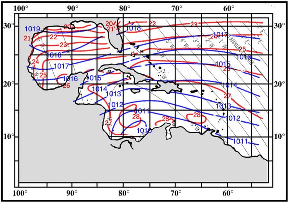
Source: PUB 106: Atlas of Pilot Charts North Atlantic Ocean (November)
Unlock the rest of this post, including our actionable checklists and complete data breakdown, by joining our community of paid subscribers today. …
Keep reading with a 7-day free trial
Subscribe to Fred Pickhardt’s Substack to keep reading this post and get 7 days of free access to the full post archives.
Be the first to comment!
SCORE Fall Newsletter – SCDNR
Michael Hodges is Retiring
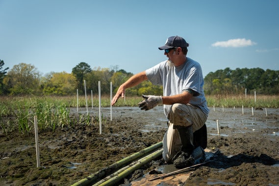
Michaels commitment to grassroots oyster restoration has always centered on fostering a sense of ownership for our natural resources. Under his tenure SCORE has educated more than 26,500 people about the importance of oysters and salt marsh resiliency through outreach efforts. Through boots-on-the-ground work and plenty of sweat equity SCORE has involved almost 67,000 volunteers totaling 144,436 stewardship hours.
Building on the foundation that Nancy Hadley laid starting in 2000, Michael has met challenges with innovation, embraced the power of volunteerism, and through the partnerships and new funding sources has scaled the SCORE program from a small grassroots restoration program to the beast it is today.
Michaels commitment to SC’s oyster resources and love for the salt marsh has aways been contagious. he has mentored many current and former SCDNR staff and left his mark not only at DNR, but on the national living shoreline stage. Today SCORE is the largest state oyster shell recycling and restoration program in the country, and many other agencies, nonprofits, and groups have applied what SCORE and Michael have created in South Carolina to their home fisheries.
Thank you, Michael, for always believing in your people and giving us the freedom to think outside the box. The estuaries will be a little less bestuary without you.
If you’re interested in helping celebrate his retirement, please reach out the score@dnr.sc.gov
New Volunteer Software
Curious on how our new volunteer software works? Watch our quick demo here
SCDNR is proud to introduce our new volunteer management platform, Galaxy Digital!
No need to fill out your volunteer information every time you come out and volunteer with us. Simply create your volunteer account once, and you’ll never have to create another account again.
Galaxy Digital will be your one-stop shop for everything SCDNR volunteer-related. You’ll be able to sign up for individual volunteer opportunities, sign up your team, view your total volunteer hours, and more!
View upcoming SCORE volunteer opportunities HERE
Roast Season
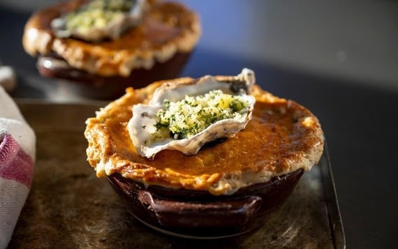
 Roast season is here! Please remember to recycle your oyster shell and to roast responsibly.
Roasting responsibly means making sure the oyster shell from your oyster roast ends up in a recycling bin so it can be used to replant South Carolinas oyster beds. This also means recycling only oyster shells and to remove trash before you recycle. Click on the link to find a recycling bin near you!
Find a bin near you 2026 Reef Season by the Numbers
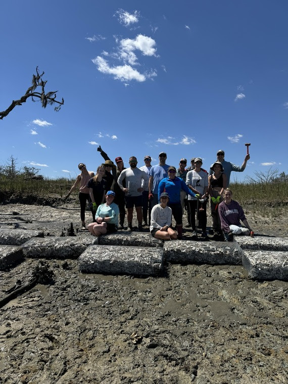
Kiawah
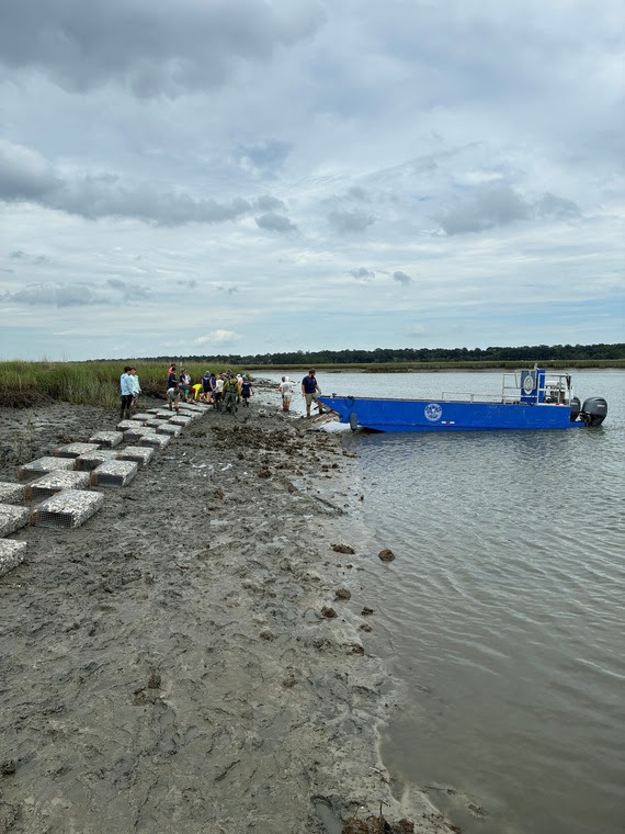 The SCORE team along with partners, Sustainability Institute and Conservancy of the Sea Islands, completed our Kiawah Bridge Project! We successfully deployed 800 manufactured wire reef units (MWRs) at four sites encompassing the bridge. The installation of these MWRs accounted for over 2,000 feet of living shorelines! These MWRs will provide the substrate needed for larval oysters to attach to, grow, and provide the amazing ecosystem services we get from having healthy living shorelines. These ecosystem services include but are not limited to habitat, erosion mitigation, and water filtration. It was tough work done well by all stakeholders involved!
AMI
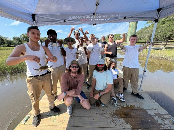
The SCORE team went out to AMI Kids Beaufort and put on an all things crabbing clinic for the boys out there. Staff members went over the life cycle, anatomy, and the rules and regulations surrounding Atlantic blue crabs (Callinectes sapidus). Staff members then taught them how to catch blue crabs with old fashioned hand lines as well as crab baskets. Several crabs were caught, then the boys were taught how to dispatch, clean, cook, and eat them. It was a great day of fellowship and understanding the resource right there on their campus! Calling all Costal Cooks
Grand Strand Area:
- Oyster shell recycling volunteers are needed! Great news is that Grand Strand restaurants are on board for shell recycling. We are seeking partners and volunteers interested in getting involved.
- Please click the link for more information.
Spe-SHELL Announcements
 Be on the lookout for Shellby in a Christmas parade around town!
Stay Connected with SCDNR: 




SUBSCRIBER SERVICES:
Manage Subscriptions | Unsubscribe | HelpBe the first to comment!
ENSO October Update – Fred Pickhardt
Fred Pickhardt’s Substack is free today. But if you enjoyed this post, you can tell Fred Pickhardt’s Substack that their writing is valuable by pledging a future subscription. You won’t be charged unless they enable payments.
 Forwarded this email? Subscribe here for more
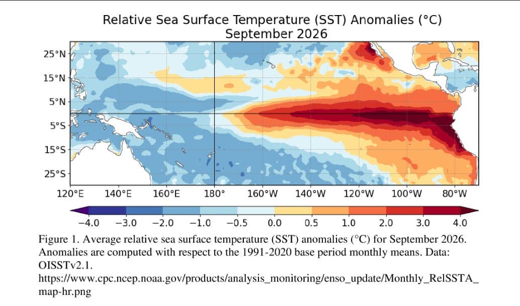
NOAA Climate Prediction Center (CPC) in their October updated ENSO Diagnostic discussion confirmed that the current El Niño has been intensifying into what could become a historic climate event. In their advisory, the CPC notes that reaching a 3-month temperature anomaly of +2.5°C or higher would exceed the strength of all previous major El Niño events dating back to 1950.
Keep reading with a 7-day free trial
Subscribe to Fred Pickhardt’s Substack to keep reading this post and get 7 days of free access to the full post archives.
Be the first to comment!




Social Media Auto Publish Powered By : XYZScripts.com
Be the first to comment!