SCDNR Coastal Updates August
|


 Women’s Inshore Saltwater Fishing Clinic (Georgetown, SC) | Thursday, July 30th, 8:30AM – 11:30AM | This clinic will teach you how to tie fishing knots, rig a rod and reel and cast. Women ages 12+ are welcome.


| Stay Connected with SCDNR: |


|
| SUBSCRIBER SERVICES: |
|
| Stay Connected with SCDNR: |
|
|
| SUBSCRIBER SERVICES: |
Cruisers’ Net Newsletter for this week has just been emailed via Constant Contact.
If you want to view the newsletter but are not signed up to receive them automatically, you can view it at https://conta.cc/3TvYmdR or see it below.
To automatically receive our emailed Fri Weekly Newsletter and Wed Fuel Report, click:
Cruisers Net publishes Loose Cannon articles with Captain Swanson’s permission in hopes that mariners with saltwater in their veins will subscribe. $7 per month or $56 for the year; you may cancel at any time.![]()
![]()
![]()
![]()
![]()
![]()
![]()
When all else fails, try journalism. Guilty Tugboat Captain Was Shopping OnlineUnder Plea Deal, He Will Serve a Year in Prison for Three Deaths
Yusiel Lopez Insua, 46, pleaded guilty Tuesday to seaman’s manslaughter in connection with the deaths of three girls learning to sail in Biscayne Bay. Insua admitted to operating a barge with obstructed visibility and without a proper lookout, which led to July 28, 2025 collision. Insua also admitted he was using his phone to visit the online shopping services eBay and Amazon. “Due to the obstructed visibility, and lack of a lookout, Insua did not see the stalled sailboat before the barge struck it,” the U.S. Attorney’s Office said in a news release yesterday. “A forensic review of Insua’s cellphone revealed internet activity during transit, including at or near the time of the collision.” Under a plea agreement Insua will serve a year in prison and six months of home confinement. The maximum sentence for the manslaughter offense is 10 years in prison. Sentencing is scheduled for October 13. (More details on the accident may be found by following the link at the bottom of this story.) What follows is the “factual proffer” behind the plea agreement:
LOOSE CANNON covers hard news, technical issues and nautical history. Every so often he tries to be funny. Subscribe for free to support the work. If you’ve been reading for a while—and you like it—consider upgrading to paid. You’re currently a free subscriber to LOOSE CANNON. For the full experience, upgrade your subscription.
© 2026 |
Fred Pickhardt’s Substack is free today. But if you enjoyed this post, you can tell Fred Pickhardt’s Substack that their writing is valuable by pledging a future subscription. You won’t be charged unless they enable payments.
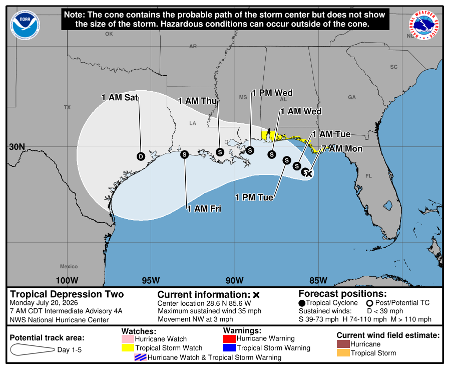
Tropical Storm Bertha is showing increased organization this morning. Deep convection has developed around the system, dropping its minimum central pressure to 995mb. Max sustained winds have ticked up to 50 knots (approx. 60 mph). The storm is currently drifting north-northwest at a slow 3 knots.
Forecast Track and IntensityA mid-level ridge centered near the Rockies is expected to move southeastward. This will push Bertha on a west-northwest to westward track, steering it near or along the northern Gulf Coast.
Despite the recent organization, Bertha remains an asymmetric storm. The heaviest rainfall and strongest winds are concentrated to the south and east of the center. Furthermore, strong northeasterly vertical wind shear will persist through tonight. This shear will make further intensification difficult. The National Hurricane Center (NHC) forecasts a gradual weakening trend over the coming days. Key Impacts and Safety Warnings
You’re currently a free subscriber to Fred Pickhardt’s Substack. For the full experience, upgrade your subscription.
© 2026 Fred Pickhardt |
Cruisers Net publishes Loose Cannon articles with Captain Swanson’s permission in hopes that mariners with saltwater in their veins will subscribe. $7 per month or $56 for the year; you may cancel at any time.![]()
![]()
![]()
![]()
![]()
![]()
![]()
When all else fails, try journalism.
The author is a retired telecom/satcom professional who cruises the East Coast with his wife Louise aboard a 52-foot steel trawler yacht named Vector. He is Loose Cannon’s go-to guy in matters of regulations and best practices. By SEAN WELSHDear U.S. Coast Guard radio watchstanders: Getting on Channel 16 when there is an open mic, to announce that there is an open mic, and to ask mariners to check their equipment, basically does nothing except add clutter to the channel, something you would be yelling at us for doing. The reason is simple, and really ought to be taught in radio watchstander school, if it’s not already: The radio with the open mic—the one radio you are trying to talk to—cannot and will not hear your announcement. When the microphone transmit button is pressed, the radio can no longer receive transmissions from other stations. Yes, yes, there is a minuscule chance that the vessel with the open mic actually has more than one radio, and one of the other radios is tuned to 16, and someone somewhere on that vessel will hear your plea, make their way to the bridge or wherever the offending radio is, and do something about it. Or perhaps the vessel with the open mic is actually in a marina, and within earshot of another boat with a radio that is on, and they will hear your call. But both of these scenarios have a likelihood that is vanishingly small. When most of us hear people making open-mic announcements, we think “does this person not know how radios work?” When it’s the Coast Guard doing it, we wonder about standards of training. FWIW. LOOSE CANNON covers hard news, technical issues and nautical history. Every so often he tries to be funny. Subscribe for free to support the work. If you’ve been reading for a while—and you like it—consider upgrading to paid. |
Cruisers Net publishes Loose Cannon articles with Captain Swanson’s permission in hopes that mariners with saltwater in their veins will subscribe. $7 per month or $56 for the year; you may cancel at any time.![]()
![]()
![]()
![]()
![]()
![]()
![]()
When all else fails, try journalism. Alternate History: ‘Real’ Odysseus Sailed to the Bahamas and BackAuthor-Sailor Also Suggests Florida Might Have Been ‘Hell’
Henk van Oosten is a Dutch sailor and professional predictor of the future. When van Oosten retired from his job as an innovation expert, he combined sensibilities from both vocation and avocation, reexamined historical assumptions and proceded to rewrite The Odyssey.
One of the greatest works of literature of all time, The Odyssey is also one of the earliest examples of a sequel. Writing around 800 years BC, Homer chronicled an epic war of Greeks versus Trojans in his poem The Iliad. The blind Greek poet hooked his audience: The war was caused by Helen, the unfaithful queen with a “face that launched a thousand ships.” With the release of the Christipher Nolan movie “The Odyssey” last week, a massive amount of attention is being paid to the story. Odysseus, the central figure in The Odyssey, was fresh from winning the Trojan War with his idea for the “Trojan horse” ruse de guerre in The Iliad. If you think of the Greek heroes of that war as celebrities such as, say, the Beatles, Odysseus would have been “the clever one.” What van Oosten had done in a series of academic papers and a book was to upend the Homeric versions and create an entirely different narrative, set not in the Greek world of the Eastern Mediterranean but the Atlantic Ocean. In van Oosten’s retro-futuristic imagination, Odysseus takes a ten-year lap around the Atlantic, to the Caribbean, then the Bahamas, Florida and the Azores before returning to his kingdom in southwestern Spain. Hilariously, van Oosten identifies Florida as possibly the Hades of Homer’s account. That is, a Hell on earth. Van Oosten was inspired by a 1990 book that posited Troy as a fortress in England, not what is now Turkey. Speaking to Fiona Cameron Lister in a July 22, 2020 story on the Medium website, Van Oosten said:
Van Oosten’s inspiration was the shield of Achilles, another Trojan war hero conventionally assumed to have been Greek. According to Homer, the shield was made by a god for Achilles and decorated along its rim by a depiction of Oceanus, now called the Atlantic Ocean. The waves of Oceanus surround a dome of the sky with the sun, moon and four constellations. Which can be used, van Oosten theorizes, for navigation to guide voyagers on the somewhat circular route still used for small boat voyages from Europe to the Caribbean and back. The fact that the Oceanus motif rims the circular shield suggests the Gulf Stream, he said.
The Iliad records the first reference in history to celestial navigation. Homer describes the nymph Calipso giving Odysseus sailing directions using the very same constellations on Achilles’ shield, according to van Oosten:
Stars Like Range Lights
Odysseus’ Imagined Route
The story is pretty involved, of course. Epic, you might say. So one of van Oosten’s papers is included below for those who want to get deep in the weeds, or you could read van Oosten’s book on the subject.
Helen of Troy doesn’t exist in van Oosten’s narrative. The Trojan War is a powerplay between various peoples along the Iberian Atlantic and British Isles involved in the mining and distribution of tin. Tin was perhaps the most strategic commodity of the Bronze Age since it was the element in bronze alloy that kept edged weapons sharp. The absence of Helen doesn’t mean van Oosten entirely ignores the love angle. None of the mentioned Atlantic islands were populated in 1400 BC, according to conventional thinking, but the science is not definitive. That gives van Oosten the wiggle room to speculate. In those places, Odysseus dallies with the same assortment of nymphs, witches and queens as had been assigned by Homer, thus maintaining a plausible explanation of why it took 10 years to sail from Cornwall in the Southwest England to his wife in Huelva.
Covering nautical news, history and now legend, LOOSE CANNON encourages you to subscribe. It’s free, and there are no ads. | ||||||||||||||||||||||||||||||||||||||||||||||||||||||
Fred Pickhardt’s Substack is free today. But if you enjoyed this post, you can tell Fred Pickhardt’s Substack that their writing is valuable by pledging a future subscription. You won’t be charged unless they enable payments.
TD2 at 5pm EDT, was centered near 28.7N 85.8W with max winds of 30 KT with a minimum pressure of 1005 mb. The strongest winds are currently south and east of the center. The low-level center is drifting northwest at only 3 knots and is forecast to move slowly northwestward to west-northwestward for 36 h or so, followed by a turn toward the west.
The depression is experiencing moderate northeasterly shear, and these conditions should continue for another 18-24 hours, after which, the northeasterly shear should increase, and cause the system to weaken. The peak intensity forecast is 45 knots in 36 hours, however, wind shear could keep that somewhat lower.
Tropical storm conditions are possible in portions of the Gulf Coast from the Florida Panhandle westward to southeastern Louisiana Tuesday and Wednesday. A storm Surge Watch is in effect for the Alabama, Mississippi, and southeastern Louisiana coasts.
Areas of flash flooding will be possible through Friday along portions of the Gulf Coast and adjacent inland locations from western Florida north of Fort Myers to the Middle Texas Coast, including southern portions of Alabama, Mississippi, and Louisiana. Latest NHC advisories: NOAA NHC You’re currently a free subscriber to Fred Pickhardt’s Substack. For the full experience, upgrade your subscription. |
|
| Stay Connected with SCDNR: |


|
| SUBSCRIBER SERVICES: Manage Subscriptions | Unsubscribe | Help |


Be the first to comment!