Visit Logged
  • Select Region
    • All Regions
    • VA to NC Line
    • North Carolina
    • South Carolina
    • Georgia
    • Eastern Florida
    • Western Florida
    • Florida Keys
    • Okeechobee Waterway
    • Northern Gulf
    • Bahamas
    • New York
    • Ohio
    • Pennsylvania
    • Washington
    • Puerto Rico
    • Minnesota
    • Maryland
    Order by:
    • Surviving a Close Encounter with a Shark

      This article comes to us from our friends at BoatNation.com.

      Surviving a Close Encounter with a Shark
      shark
      The best way to avoid a shark attack is to simply stay out of the ocean. On the other hand, it’s difficult to resist a dip in the water on a warm day. If you do decide to go for a swim, keep the following tips in mind. You may not be able to prevent an attack, but you may be able to minimize your injuries. Believe it or not, unprovoked shark attacks on humans are rare with an average of around 75 per year, resulting in about 10 deaths worldwide. You have a greater chance of dying from a bee sting or being hit by lightning.


      Avoid being in the water from sunset to sunrise. This is when sharks are most active.

      Avoid being in the water near where people are fishing.

      Also avoid swimming during or after storms, which can make the water cloudy and churn up the fish that sharks feed on. They won’t be able to tell if you’re human or prey. The same applies to river mouths – where the water can be muddy.

      Avoid peeing in the water. It’s not just blood that they are attracted to. Sharks are attracted to urine. A lot of cases of surfers and divers, that have been attacked by sharks, have been preceded by the need to urinate. Another good idea if you need to pee in the water, wetsuit or not, is to let it go in the white water. Action from the waves gives it a better mix, and it’s not as likely to attract the sharks nose

      Do not swim if you have a bleeding cut or abrasion. Sharks sense blood and are attracted to even a tiny amount in the water. Sorry ladies, stay out of the water if you are having your period.

      Don’t take your eyes off the shark. Don’t turn your back on the shark as you move. Remember, it’s important to keep the shark in view. Make eye contact when possible and try to keep your eyes on the shark at all times. Sharks like to attack from behind. Keeping your eyes on the shark may help to avoid an attack. In open water, get back-to-back with another swimmer or diver so that you can see, and defend against, an attack from any direction. If possible, Slowly back up against a reef, piling, or rock outcropping – any solid obstruction ‘“ so that the shark can’t circle around behind you. This way you only have to defend attacks in front of you.

      Stay in a group. People on their own are more likely to be attacked than large groups. Don’t wander too far from the shoreline.The further you are from the shore, the further you are from help.
      Choose your attire carefully. Avoid wearing shiny jewellery, because the reflected light resembles the shimmer of fish scales. Also don’t wear brightly-coloured or patterned clothing, because sharks see contrast particularly well. Special striped wetsuits which look like poisonous, black and white banded sea snakes are being tested which warn a shark that a diver or surfer isn’t safe to eat.

      Stay still and remain calm if you spot a shark. Most sharks are just curious and will leave on their own. Attacks are very rare.

      If you are attacked, fight back. If you are targeted by a shark, the general rule is, do whatever it takes to get away – but do it calmly. Try to fight back and startle it. The best place to hit is its nose. Also try to claw at its eyes and grab its gills, two of the most sensitive areas on a shark. Make sure you’re able to defend your front and sides and use a weapon like a surf board if possible, don’t use your hands. If you are bitten, stop the bleeding and get help as soon as possible.

      Special thanks to George H. Burgess, senior biologist in Ichthyology at the Florida Museum of Natural History

      shark2

      Stay Safe and Happy Boating!
      Ashley and the Crew at BoatNation.com

      BoatNation.com was founded to offer affordable advertising options specifically for promoting boating businesses as well as private sellers. BoatNation.com is not only a comprehensive Boating Resource Directory, it also provides a cost effective venue for buying and selling new and used boating equipment, waterfront real estate, boats and much more.

      Be the first to comment!

    • Cuba Anyone? Normalization May Open Ports to Non-Commercial Vessels

      According to this article from Trade Only Today, boats cruising to Cuba would find refueling difficult and only the basic facilities at existing marinas. Still for those of you with the craving for new waters and new ports, the prospect of taking your boat to Cuba must be absolutely mouth-watering.

      U.S.-Cuban ties could be boon to marine industry
      Posted on July 20th, 2015

      cubamap

      After 54 years of animosity, the United States and Cuba formally restored diplomatic ties.

      This morning, the United States opened an embassy in Havana and Cuba opened an embassy in Washington, D.C.

      In truth, both countries had for years already been running robust interest sections in both capitals. Today, however, both of those missions were upgraded.

      This afternoon, the Cuban flag will be raised on the grounds of the Cuban Embassy in Washington for the first time since 1961, according to National Public Radio.

      U.S. Secretary of State John Kerry will travel to Havana to raise the American flag at the U.S. Embassy there at a later date.

      Starting today, U.S. officials said, the Cuban government will pull back some of the tight cordon of security that had surrounded America’s diplomatic mission in Havana and no longer will record the names of Cubans entering the building, according to CNN.

      The Cuban and American heads of their respective interest sections will became charges d’affaires until ambassadors are named.

      `A new stage will begin, long and complex, on the road toward normalization,’ Cuban President Raul Castro said in a televised address last week to the Cuban people. `Which will require the will to find solutions to the problems that have accumulated over more than five decades and hurt ties between our nations and peoples.’

      The National Marine Manufacturers Association recently announced a third and final exploratory trip to Cuba, set for December.

      Cuba has 11 million residents, and if it were a U.S. state it would rank seventh in population, according to the NMMA. Cuba has 1,400 miles of coastline similar to the Florida Keys ‘” if the Cuban Keys were superimposed on the Atlantic Seaboard, they would stretch from Miami to New York.

      The NMMA said Cuba also has more than 100 freshwater lakes suitable for boating. Built by the Soviets from the 1960s through the 1980s, the 3- to 5-mile lakes irrigate rice fields and teem with largemouth bass. That means 95 percent of Cubans live within five miles of boating waters.

      In December, NMMA export director Julie Balzano told Trade Only about the association’s second visit to the Caribbean’s largest island.

      `If and when U.S. boaters would be allowed to go to Cuba by boat, I think probably there is enough infrastructure in place at the moment, though I think it would be basic for American boaters visiting Cuba,’ she told Trade Only at the time. `I think they struggle a bit with fueling stations in marinas,’ for example.

      `Cuba, just the country itself, is struggling with infrastructure,’ she said. `If tourism grows, they’re going to struggle with hotel occupancy and eateries. It’s still a challenge to get basic items in Cuba.’

      The island, though, has a lot to offer boaters in terms of its beauty. `It’s lush and green and mountainous, and the waters are crystal-blue,’ Balzano said.

      Comments from Cruisers (1)

      1. Don Haynie -  July 24, 2015 - 3:02 pm

        Planning to go!

        Reply to Don
    • More Good Words for Spoon River Restaurant, Belhaven, NC, AICW Statute Mile 136


      Spoon River Restaurant has only been in business for two years and is open seven days a week. They are located just off the waterfront and are listed as:
      Spoon River Artworks and Market
      263 Pamlico St, Belhaven, NC ‘Ž
      (252) 945-3899
      And their Facebook address is:
      https://www.facebook.com/pages/Spoon-River-Artworks-and-Market/471584979558789
      There are several opportunities for dockage near Spoon River: Belhaven Waterway Marina, Belhaven Town Dock and Belhaven/Pantego Creek Anchorage. Our thanks to Skipper Whitehead for reminding us of this excellent restaurant!

      We had dinner at Spoon River last night and it was undoubtedly the best meal we have ever enjoyed. The menu choices and the food are excellent. The waitstaff are excellent and well trained. All in all a very pleasant evening. I would give them five stars!
      Carol Whitehead

      Click Here To View the North Carolina Cruisers’ Net Marina Directory Listing For Belhaven Waterway Marina

      Click Here To View the North Carolina Cruisers’ Net Marina Directory Listing For Belhaven Town Dock

      Click Here To Open A Chart View Window, Zoomed To the Location of Belhaven Waterway Marina and Belhaven Town Dock

      Click Here To View the North Carolina Cruisers’ Net Anchorage Directory Listing For Belhaven/Pantego Creek Anchorage

      Click Here To Open A Chart View Window, Zoomed To the Location of Belhaven/Pantego Creek Anchorage

      Be the first to comment!

    • Question Regarding Lake Level in Lake Okeechobee


      Those of you who are frequent Lake Okeechobee Waterway cruisers are certain to have answers for Skipper Bill’s questions. Let us hear from you! USACE daily lake level reports can be found at http://w3.saj.usace.army.mil/h2o/currentLL.shtml. However, Bill’s questions refer to ARGUS soundings for Lake Okeechobee. See /?p=148612. ARGUS soundings are shown on all SSECN Chartview pages by clicking the ARGUS button at the top of the chart.

      What lake level are the soundings in Lake Okeechobee corrected to, or what lake level were they observed? Since there is no `MLLW’ the lake level at observation or correction to the standard lake level is essential.
      Thanks,
      Bill

      argusokee

      Comments from Cruisers (1)

      1. John Hersey -  July 20, 2015 - 2:43 pm

        Hi Bill,
        For Lake Okeechobee we get the daily lake level reports from the Corps of Engineers and refer that to the 12.5 foot average as used for the NOAA charts. Then we apply that difference to the soundings for each day. Please let us know if you see anything that looks odd though, so we can investigate and make adjustments to the process if possible.
        Thank you,
        John Hersey
        SURVICE Engineering

        Reply to John
    • Advice Sought on John Pennekamp Coral Reef State Park and Largo Sound, Key Largo, FL


      The entrance channel to John Pennekamp Coral Reef State Park Marina is found off Hawk Channel, on the east side of Key Largo, at flashing red marker #2 which lies west, northwest of Hawk Channel marker #35 off Mosquito Bank. Largo Sound Mooring Field is managed by the State Park marina. The most last report we have (/?p=136094) seems to indicate that Skipper Joe will be fine with a 4’3″ draft, but if you have more recent experience entering Largo Sound, let us hear from you.

      I get a mixed bag of comments regarding entrance to Largo Sound’¦I will be arriving in Leopard 43 which draws 4’3’ Is it possible to enter into the Sound’¦would love to experience the park from inside??? I appreciate the help.
      Joe

      Click Here To View the Cruisers’ Net’s Florida Keys Marina Directory Listing For John Pennekamp Marina

      Click Here To View the Florida Keys Cruisers’ Net Anchorage Directory Listing For Largo Sound Mooring Field

      Click Here To Open A Chart View Window, Zoomed To the Location of Largo Sound

      Be the first to comment!

    • 418ft National Security Cutter Coming to Charleston, SC

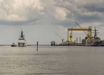
      South Carolina is proud to have the National Security Cutter James make Charleston her home port. NSC 5 is named to honor Capt. Joshua James, one of the world’s most celebrated lifesavers.

      USCG’s New Cutter Sails from Ingalls
      Posted by Eric Haun
      Thursday, July 16, 2015

      The National Security Cutter James (WMSL 754) sails away from Ingalls Shipbuilding. (Photo: Lance Davis/HII)

      The National Security Cutter James (WMSL 754) sailed away from Huntington Ingalls Industries’ (HII) Ingalls Shipbuilding division on Sunday, July 12, one month after being delivered to the U.S. Coast Guard, HII announced.
      The new built vessel James will be commissioned on August 8 in Boston before heading to Charleston, S.C., where she will be stationed alongside Ingalls’ fourth NSC, Hamilton (WMSL 753).

      “James is an excellent ship and another example of the outstanding work accomplished by our shipbuilders,” said NSC Program Manager Derek Murphy. “Through serial production in this program, each successive ship continues to come down the learning curve. The quality remains world-class, as proven by the substantial reduction in the number of trial cards with each successive ship in the class. Ingalls shipbuilders have once again delivered an NSC that will continue to protect our nation for the next 40 years.”

      CLICK HERE for the full story from MarineLink.com

      Be the first to comment!

    • Openings Questioned at Socastee Swing Bridge, AICW Statute Mile 371


      Skipper Lattimer poses questions that have asked many, many times over the years. See /?p=89755 and /?p=143206 for comments from other boaters. As to precedents for openings, emergency vehicles and vessels get priority. On weekends, it is normally water traffic that is heavy and the On Demand must restricted to openings every 15 minutes. During weekday rush hours, the opposite is true. And, as I understand from conversations with the bridge tenders, the old swing bridge roadway still serves a nearby school zone, requiring that waterway traffic be restricted for school buses. It is a tough job for the tenders who must rely on their on-the-spot judgement to apply restrictions.

      Re: Socastee swing bridg . What do you mean `Opens on Demand’ Demand from who? Also, how many boats are considered heavy vessel traffic? It’s not unusual to have a hundred, probably a lot more, cars and trucks tied up when the bridge is open to `some’ boats. Which should take precedence?
      Ed Lattimer

      Click Here To View the Cruisers’ Net’s South Carolina Directory Listing For Socastee Bridge

      Click Here To Open A Chart View Window, Zoomed To the Location of Socastee Bridge

      Comments from Cruisers (1)

      1. Jim Healy -  July 24, 2015 - 2:32 pm

        What should take precedence, Ed, is the USCG-approved status of the bridge. The Socastee Bridge is NOT restricted, so by definition, it is “on request”/”on demand.” The “requestor”/”demander” is the pilot of the boat. Having transited the ICW on many fall/spring migrations, I have experienced all of the ICW bridges. At Socastee, I have had excellent service and terrible, disrespectful service. The bridge is unreliable, at best. The bridge operations staff is made up of people who believe in serving the needs of boaters and people who do not. The argument of emergency vehicle traffic or school bus traffic applies to every bridge everywhere. There is absolutely nothing unique to Socastee. The bridge – and the city that owns the bridge – should honor it’s commitments to waterway users. Honor them or change them, but none of this, “it’ll be about 15 minutes or so before I can open” nonsensical stuff.

        Reply to Jim
    • Photo of the Week

      Key Biscayne Light

      Key Biscayne Light

      Be the first to comment!

    • Boca Ciega Bay Community Group Forms to Clear Derelict Boats, near GICW Statute Mile 115


      Grassroots movement hopes to rid Boca Ciega Bay of derelict boats

      Date Reported: Jul 15, 2015
      Reported By: Mike Ahart, News Editor

      A grassroots movement has started up around Boca Ciega Bay to help rid the area of its growing derelict boat problem.

      How has your community solved or reduced its derelict boat problem? Citizens Against Derelict and Illegal Boats (CADIB) wants to know ‘“ and wants others in their own communty to help. CADIB’s mission statement: “To protect our waterways from the environmental and navigational hazards that arise from derelict and illegal vessels.”

      According to Grant Bond, one of the organizers of CADIB, “We would like to learn from and help other areas that have been affected by this problem. We (know) our current situation in Gulfport Florida…about 30-50 vessels dragging anchors, half of them have no registration or no current registration. I have lived on the water for 3 years and have seen 6 boats wash up on residential seawalls, 5 sunken vessels sitting on top of protected mangroves in Clam Bayou and at least 2 have caused damage to city property.”

      So far, CADIB has been keeping track of boats and registration, and members have attended city council meetings to help keep the issue in the forefront. If you would like to help CADIB on the water or with ideas, contact by email CADIBgulfport@gmail.com

      “Join us in the fight to keep our waterways to their natural beauty.” Visit the brand-new CADIB website for updates.

      CLICK HERE for the full story.

      Click Here To View the Cruisers’ Net’s Western Florida Marina Directory Listing For Gulfport Municipal Marina

      Click Here To Open A Chart View Window, Zoomed To the Location of Gulfport Municipal Marina

      Click Here To View the Western Florida Cruisers’ Net Anchorage Directory Listing For Gulfport Anchorage/Mooring Field

      Click Here To Open A Chart View Window, Zoomed To the Location of Gulfport Anchorage/Mooring Field

      Be the first to comment!

    • Update: Stolen Yacht Recovered, East Coast of Florida, near Fort Lauderdale

      Our thanks to Mike Ahart, Editor of Waterway Guide for this news:

      Waterway News Updates
      Florida East Coast

      Has anyone seen this stolen yacht?

      Date Reported: Jul 15, 2015
      Reported by: Kevin Crago
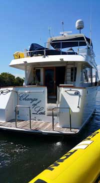
      Changes-Of-Latitude.jpgHas anyone seen me? My name is Change of Latitude. I am a 2002 Ocean Alexander 60′ Pilothouse Motor Yacht. I was stolen Sunday at 1:30AM from Harbour Towne Marina in Dania Beach FL. I am most likely in the Bahamas.

      Please notify Kevin Crago, the Bahamas Defence Force, US Coast Guard, US Customs, US Marshals, or Broward County Sheriff if you see me.

      Ed. note: WG has verified that this yacht has indeed been stolen. Information has been posted elsewhere on the internet suggesting that the boat is missing due to a repossession. The boat had been repossessed a few months ago.

      View location on the Waterway Explorer
      Source: Cruising Boater

      CLICK HERE for the full story from Waterway Guide Latest News

      Comments from Cruisers (1)

      1. Mike Ahart -  July 20, 2015 - 11:10 am

        UPDATE: The yacht has been located, no details are currently available. BOLO (Be On the LookOut) has been canceled.

        Reply to Mike

    Social Media Auto Publish Powered By : XYZScripts.com