Skipper Price’s experience confirms earlier reports, /?p=149149, we had in June. Advice at that time was to favor the red side. The intersection of the ICW and Lockwoods Folly has been a Problem Stretch for years and requires almost annual dredging. Mid to high tide is recommended for passage.
Just an FYI in case the word has not gotten to you guys but Lockwoods Folly Inlet is very shoaled up already. I know of one fellow boater that ran aground there about 30 days ago and I have been thru there twice myself in a boat that draws 4.5’ at a little past mid tide and rising. My depth finder showed 2.5’ under my keel. I could not go thru there at low tide! Bob Price
Just came through this area (unfortunately due to a delay at low tide). 4.5 draft got hung up when I turned toward the Green. Hug the Red side, and stay away from the Green. Saw a few similar draft vessels get through on the red side without issue. Floated off after 20 mins, a useful lunch break.
Skipper Crenshaw’s grounding occurred in a long narrow channel through the wide waters of Bogue Sound, south of Morehead City. There are charted shoals showing outside the channel to the south opposite Marker #8 and these may have begun to encroach on the channel. If so, Skipper Crenshaw’s advice to favor the red side is certainly a good one. Thank you Bob for sharing your experience.
I was on ICW headed south in Morehead city toward Wrightsville Beach Sunday September 20 about 10:45 am on rising tide. We have 42 foot trawler with 4 foot draft. We were at MM 210 running about 10 to 12 Knots and were at least 5+ feet inside markers between green marker 7 and marker 9 and went hard aground and boat stopped immediately , my depth indicator was showing2-3 feet. We were able to get off after about 15 minutes . Would recommend any boat favor the red side markers, where there appears to be plenty of water around this MM. Bob Crenshaw 42 Trawler 4 foot draft.
Just to clarify the post, the ICW runs east/west through Bogue Sound, and the shoaling is on the south side of the channel opposite Red #8, not east as in the description of the post. [Posting corrected.]
The Skippers Herl begin their Waterway run with a stop at Portsmouth and we look forward to their voyage reports as they motor south. Tidewater Yacht Agency in Portsmouth, VA, is located on the west side of Town Point Reach in the Norfolk harbor, hard by Mile Zero, and has served many Waterway cruisers as a jumping-off point for their voyage “down the ditch.”
Portsmouth, VA 9/15/15, Arrived at the Tidewater Marina in Portsmouth, Va. Had a long day over nine hours but a beautiful run, very pleasant. This also marks the beginning of our trip south. Were able to get an Rx filled and to walk in town and visit some of the shops. Also were able to get a pumpout and top off the fuel at a good price.($2.20) though after we left Portsmouth we did see better prices, oh well whats $.10 a gal. Sandy and Phil Herl
As Skipper Herl relates, Coinjock Marina, on the eastern bank of the Waterway, offers more than just good marina services, but delicious food as well! And sometimes that makes a big difference in where we tie up.
Coinjock running south Aaaah Coinjock again, I’m not sure why, but I like Coinjock. It was a good run,we had no problems with the bridges or the lock and trafic both northbound and southbound was light. Oh, I know why I like Coinjock. It’s the food. I had a Reuben the first time and It was one of the best. This time we had their famous Prime Rib and it was outstanding, melt in your mouth and we could not eat it all. And we just had the Mate size not the Captains. It was great with all the fixins. Phil and Sandy Herl
Whether on my own boat or a delivery, have made this a required stop for more than 20 years. Lots of places claim they have the best prime rib in he world but this is it!!!
Port Royal Landing Marina, A SALTY SOUTHEAST CRUISERS’ NET SPONSOR, is a perfect example of true Southern hospitality and of a marina family that cares about boaters! Port Royal Landing Marina guards the western banks of Beaufort River just south of marker #244.
Port Royal Landing Marina welcomes you and your crew! The delightful hospitality that you find in the Low Country of South Carolina is often referred to as “The Royal Treatment” here at Port Royal Landing Marina. Our staff is available and anxious to do everything we can to exceed your expectations of quality and service. It is our goal to make your stay at PRLM the most pleasant marina experience you have on your trip. We intend to be the standard by which you judge all other marinas along the waterway. CLICK HERE for a video introduction to Port Royal Landing Marina.
Royal Treatment Slow down, sit back, and relax. Stay another day or two. Enjoy the surrounding historic area, our facilities, and our service. Take advantage of our location between the two historic towns of Beaufort and Port Royal. Get a large dose of that Low Country “Royal Treatment” and we believe you too will find us habit forming! Problems? Let one of our knowledgeable staff members help. We can’t solve them all, but when we cannot, we will make every effort to find someone who can. CLICK HERE for bios of the Port Royal Landing Marina Staff
Historic Port Royal and Beaufort When berthed at our marina, you are surrounded by history. Jean Ribaut sailed into the Port Royal Sound in 1562 and wrote to his sponsors in France that there was “no fairer no fitter place.” His way of saying “it just doesn’t get any better than this.” He liked the area enough that he established the village of Port Royal that same year. Beaufort is a relative newcomer, chartered much later in 1711. Today, these two historic towns are separated only by the width of a sign post at the Burger King on Ribaut Road, which runs through both towns. This entire area is known for some of the finest hospitality in the South. We will be glad to make dinner reservations for you or to provide information on any of the many attractions in our area. There are many magnificent antebellum homes along the water and on Bay Street in downtown Beaufort- some of which are open to the public, such as the John Mark Verdier House. Even those that are not open to the public are still worth a trip by foot, bicycle, tour bus, horse drawn carriage, or our courtesy car to take a look at their magnificent pre-civil war construction. The area, and specifically some of these homes, has been host to a number of award-winning movies such as Forrest Gump, The Big Chill, The Prince of Tides, and The Great Santini (The last two were written by local author Pat Conroy). In fact, in the closing scene of The Prince of Tides, our marina can be seen as Nick Nolte rides over the adjacent bridge. In addition to the antebellum homes, there are several pre-civil war churches, the Beaufort Museum, fine antique stores, horse and buggy rides in the downtown area, tabby ruins at Old Sheldon Church and Dataw Island. Beaufort also features Hunting Island State Park, Parris Island, and the Penn Center, where the native Gullah traditions and language are preserved and nurtured. We will be glad to give you directions, provide you with maps, lend you the courtesy car, or drive you downtown to get started.
On-site Facilities: Ship’s Store– Located landside, you will find our ship’s store stocked with many marine items that you may need. We are a Land-N-Sea overnight order center. Should we not have what you need in stock, our 25,000+ item catalog probably does. Orders in by 3:00 PM are delivered around noon the next day with no freight charge to you. Deliveries are made Tuesday through Friday. Courtesy Car– The marina has a courtesy car available for your convenience. It is available for short trips in the area during normal marina hours. ATM machines, grocery stores, pharmacies, auto parts stores, medical facilities, banks, churches, golf courses, and shopping in downtown Beaufort or Port Royal are all just a short ride from the marina. We can provide you with a map and directions to any of these locations. Dock Carts– For ease in moving those supplies up and down our pier and docks, we have available a number of dock carts for your use. Also, if you need some additional hauling power, we can help with one of our golf carts. Just let us know! Shower and Restroom Facilities– Clean, code secured, well-lit showers and restroom facilities are located adjacent to the ship’s store. Detergent, toothbrushes, toothpaste, soap and other toilet articles are available in the ship’s store for purchase. Laundromat– We have an on-site laundry facility open twenty four hours for your convenience. The Back Porch Grille– Also landside, you will find the Back Porch Grille, our own little taste of waterway America. They serve what according to many of our repeat customers is the best cheeseburger on the ICW. A menu is included in your welcome package and we hope that you will give it a try. A ten percent discount is available for our visiting boaters. There is usually live entertainment on Friday and Saturday nights. The food is good, the service fair, the beverages cold, and the clientele… well, they are a study in themselves. The Back Porch Grille opens daily at 11:00 AM (opens at 4:00 PM on Mondays) and the food is available until 9:00 PM (or later with notice.) The bar closes around midnight, and it can be an adventure. Stop in and give it a try. Thank you for staying with us, best wishes, and safe passage. Please let us know what you have seen along the waterway that we might use to improve your next stay. Just a walk or short bike ride away:
Food & Beverage .4 miles………….Hardee’s: breakfast, burgers, sandwiches and fried chicken .5 miles………….Agave: Mexican grill (authentic Mexican cuisine) .6 miles………….Piggly Wiggly: grocery store .6 miles………….ABC Wine & Spirits: beer, liquor and wine .45 miles……….Alvin Ord’s: fresh made sandwiches and taco salads, etc. .45 miles……….CJ Seafood Express: fresh seafood market (shrimp, fish, crab, etc.)
Cypress Wetlands Boardwalk
.76 miles……….Mizu Japanese Restaurant: hibachi steakhouse and sushi .7 miles………….Port Royal Farmers Market: local produce and various fresh foods. Saturdays 8-12pm .8 miles………….Pizza Hut: dine in and delivery pizza .9 miles………….Carolina Tavern: wings & ribs sports bar 1.6 miles……….Smokin Planks: family owned and operated BBQ and Smokehouse 1.6 miles……… 4 Island Pizza: take out & delivery only 1.9 miles……….La Nopalera Restaurant: Mexican food 1.1 miles……….Red Rooster Café: breakfast & lunch meals Monday through Saturday 1.7 miles……….11th Street Dockside Seafood Restaurant: overlooking shrimp docks on Port Royal Sound 1.9 miles……….Moon Doggies Café & Grill: great American food meets Southern hospitality 1.9 miles……….Athenian Gardens: authentic Greek dishes with American friendly options 1.9 miles……….City Java: local coffee shop, breakfast & lunch 2.7 miles……….Publix: grocery store 2.8 miles……….Rancho Grande restaurant: Mexican food 2.8 miles……….Island Meat Market: Family owned market with full selection of prime cut meats 2.8 miles……….Bill’s Liquor: great selection of craft beer, premium liquor and fine wines Medical Care & Pharmacy .4 miles.………..CVS Pharmacy .4 miles………….Doctor’s Care Medical Facility .8 miles………….US Naval Hospital 1.7 miles………..Keyserling Cancer Center 1.85 miles………Dentists & Family Doctors, etc. 1.9 miles………..Beaufort Memorial Hospital Other Businesses & Services .4 miles…………Citgo Service Station .4 miles…………Advance Auto Parts .5 miles…………Ferguson Enterprises: plumbing, bath, kitchen & lighting .6 miles…………West Marine .6 miles…………MCAS Credit Union & ATM .6 miles………..Music Cooperative: Instrument sales, service and lessons .75 miles………CAPA’s Closet: thrift store benefiting abused children and child abuse prevention 1 mile…………..Roy’s Aquarium: pets & supplies 2.8 miles………Grayco Hardware & Home: family owned hardware and home goods store
Thank you for staying with us, best wishes, and safe passage. Please let us know what you have seen along the waterway that we might use to improve your next stay.
CLICK HERE for a feature on Pat Conroy’s 69ft yacht, The Prince of Tides
As local commissioners struggle to fund the current free pumpout service, it becomes apparent that those costs may soon transfer to boaters, as reported in the article below by Kevin Wadlow in KeysInfoNet.com.
Boat sewage pumpout costs likely to be assessed on the boaters BY KEVIN WADLOW A boat-pumpout program launched to protect Florida Keys nearshore waters from sewage discharges stands as a model for the state, but state funding for the program is drying up.
Money from the state’s Clean Vessel Act “dropped significantly this year,” Monroe County Marine Resources administrator Rich Jones told county commissioners Wednesday at their Key Largo meeting. Local contractor Pumpout USA “had a lot of trouble making ends meet this year,” Jones said. Monroe County in 2015 will spend about $367,000 on the program, with the state funding around $319,000 toward an estimated 18,000 vessel sewage pumpouts. The county’s share works out to $21.10 per pumpout. Overall, average total per-pumpout cost is about $40, down from $55.70 in 2014. The state Department of Environmental Protection now seeks “throughout the state to build sustainable pumpout programs, using Monroe County’s pumpout program as a model,” Jones said in a report to commissioners. To reduce the number of illegal sewage discharges in Florida Keys National Marine Sanctuary waters, the pumpouts are offered free of charge to boaters. However, commissioners have urged staff to work toward some type of fee system for boaters. “I am concerned about the long-term viability of free pumpouts,” Commissioner Heather Carruthers said. “We can’t count on the state for anything.” Commissioner Sylvia Murphy said her office receives “a constant supply of comments” from land residents “who pay for sewage” while anchored liveaboard residents “are not paying taxes or rent or anything else, and we’re paying for their sewage.” “I like doing something to keep sewage from going in the bay or ocean but sooner or later we’re going to get on the stick and make them pay,” Murphy said. Pumpouts are mandatory inside local managed anchoring areas, where Jones said compliance “is close to 100 percent.” Commissioners asked about extending the pumpout requirement to all nearshore Keys waters, but questions about jurisdiction and enforcement were cited as potential obstacles. Staff is “looking at any and all alternatives,” Jones said.
While we here in the warm southeast normally do not concern ourselves with winterization, folks in Virginia and North Carolina had harsh icing and freezing last winter and some are forecasting another cold winter this year. BoatUS remains the premiere advocate for boater safety on any waterway and we are proud to have them as SPONSORS!
NEWS From BoatUS Boat Owners Association of The United States 880 S. Pickett St., Alexandria, VA 22304
FOR IMMEDIATE RELEASE Press Contact: D. Scott Croft, 703-461-2864, SCroft@BoatUS.com
Unlike this vessel, boats that are properly winterized are most likely to enter next year’s boating season without damage and ready to hit water (credit: Jack Hornor).
No-Cost `Boater’s Guide To Winterizing’ Offered by BoatUS
ALEXANDRIA, Va., September 16, 2015 — Water expands in volume by about nine percent when it freezes, creating a staggering force that can crack a boat engine block, damage fiberglass, split hoses, or destroy a boat’s refrigeration system overnight. As cold weather approaches, Boat Owners Association of The United States (BoatUS) dug into its claims data and found that more than three-quarters of winter-related claims involved cracks in the engine block or the exhaust manifolds. Now, the national boating services, safety and advocacy group has available at no-cost a 15-page `Boater’s Guide to Winterizing‘ that can ensure boaters don’t miss a step for any type of boat.
`Boaters up North know they need to winterize, so their freeze claims almost always involve poor winterizing,’ said BoatUS Director of Technical Services Beth Leonard. `In the temperate South, the issue can be a case of no winterizing, or relying on a heater when the electricity goes off, usually when you need it most.’
The downloadable brochure addresses the reasons for more than 95 percent of the freeze claims handled by the BoatUS Marine Insurance Program in the past decade. Included are chapters on: Storing your boat – The options and the tradeoffs; a Winterizing Checklist to use as the starting point for creating your own boat’s winterizing list; Engines and Drives – The dos and don’ts; and Plumbing – Getting the water out, which is great for larger boats.
Additional information includes tips on choosing antifreeze, lessons learned from BoatUS Consumer Affairs about protecting yourself with a winterization contract, and green winterizing information.
About Boat Owners Association of The United States (BoatUS):
BoatUS is the nation’s largest organization of recreational boaters with over a half million members. We are the boat owners’ voice on Capitol Hill and fight for their rights. We help ensure a roadside breakdown doesn’t end a boating or fishing trip before it begins, and on the water, we bring boaters safely back to the launch ramp or dock when their boat won’t, day or night. The BoatUS Insurance Program gives boat owners the specialized coverage and superior service they need, and we help keep boaters safe and our waters clean with assistance from the non-profit BoatUS Foundation for Boating Safety and Clean Water. Visit BoatUS.com.
Don’t confuse Barefoot Marina, A SALTY SOUTHEAST CRUISERS’ NET SPONSOR!, with Barefoot Landing Transient Dock, which is located on the eastern (ocean) side of the AICW in Myrtle Beach, while Barefoot Marina guards the western banks.
9/11/15 My husband and I cruised icw from south harbor marina to barefoot marina for our first adventure on the icw. Upon our arrival at barefoot; we informed the dock master that my husband could use some assistance in docking due to being partially disabled from a stroke 6 years ago. They were more than welcome to accommodate us and assist us in anyway possible upon arrival and departure and our entire stay. They are definitely a must stop on your travels. MOST definitely we will be returning to barefoot on our next adventure. Thanks so much to Barefoot Marina for a Great first experience!!! Joe Miller
You only have to spend a short time talking with Randy Mims to know that he has the soul of a true sailor. Randy not only built his 27ft gaff-rigged cutter, Ideath, but each year he single-hands the cutter from North Carolina to the Northern Gulf Coast and back again. “Ideath” is pronounced Idea-th and loosely translates as “house of ideas”. Randy stops along the way to visit maritime museums and, indulging his passion for music, he volunteers to sing in church choirs along the way. He also takes time to share his travels with his friends and has agreed to allow SSECN to post his emails. For more photos and more on Randy, go to http://towndock.net/shippingnews/ideath?pg=1 from TownDock.net in Oriental.
Randy Mims
August 29, 2015 Dear Friends, Well, for the first time since leaving, I am north of where I started in Apalachicola. Today finds me in Fernandina Beach. (Still in Florida, but just barely) It has been an amazing ride up here from where I came out of the Okeechobee at St Lucie. I listened to the weather forecast for the coast north and the wind prediction was for light and variable wind. Of course it built a little each afternoon but would die after the thunderstorm. I decided to take the Intracoastal Waterway route. The prospect of getting caught out in the ocean this time of hurricane season did not have a lot of appeal. The remnants of Danny were still lingering. In a previous update several voyages ago I explained how while going down the waterway, sometimes the current was against you and sometimes it pushes you along. I am happy to say that the decision to come in the waterway was a fantastically good one. By the luck of the tide, I have been averaging forty to fifty miles a day running the engine two hundred RPMs less than my normal cruising speed. Only twice have I had to contend with a bad current. This translates into going three knots instead of five or six. Several times I magically arrived at major inlets like St Augustine and Ponce-de-Leon just as the tide turned. I had the out going tide sucking me in and the incoming tide pushing me on. The only real trials of the trip have been my wrenched knee and some very fierce thunderstorms. One night I was trying to make it to Daytona. The closer I got to my anchorage the blacker the sky got. I have to admit that the lightning show was most impressive. It seemed to take forever for the red mark where I could turn into the anchorage to arrive. I have to say I am hugely grateful that the blast of wind and torrent of rain waited until five minutes after the anchor was down instead of before. I have stopped and come ashore here because the forecast was that Tropical Storm Ericka as suppose to come here. Some of you will remember that it was here that I sat out Tropical Storm Berol that missed being a hurricane by one mile an hour. Looks like I dodged the bullet as the track when I woke up this morning is that she is going to Apalachicola. Everyone there said I should stay because of the storms. So far my luck is holding and I am having a great time! I hope you all are and that it is starting to cool off where you are a little bit. I’ve posted a couple more videos on youtube and Facebook. Please check them out. Peace and Love to all of you, Randy
The Gaff Cutter Ideath
September 9, 2015 Dear Friends, This update finds me anchored in Taylor Creek in Beaufort (pronounced BOWFORT)North Carolina. Although I have been in North Carolina for the last two days, I consider this the firs t destination in the “Voyage to NC”. This is the first place I have come to in NC that I have friends to visit, people to play music with and a church that when I walk into the choir room people will say “Hey you’re back you’re back!” For those of you interested in statistics, since leaving Apalachicola 32 days ago I have traveled 1092 nautical miles. I had planned to do a lot more sailing but apparently the dog days of summer are not the best from a wind standpoint. Mostly there just wasn’t very much and what there was seemed to always be coming from exactly where I wanted to go. I was trying to remember today as I traveled along where I put my feet on the ground. There was St. Pete where I have so many wonderful friends. The next place was LaBelle, Fl. on the Okeechobee waterway where I bought Ice to try and get the swelling down in my knee and then St Lucie to buy fuel. My next real stop was Fernandina where the last update came from. Since then I have set foot on a fuel dock in Georgetown, SC and one in Carolina Beach,NC. So from Apalachicola to Beaufort I touched the ground six times. I am sure that now that it is getting into September I will have some great sailing days ahead. I am posting a new video on youtube called “One True Reason” I will also share it on Facebook but I don’t really DO Facebook. I hope you enjoy it and share it around. Thank you so much for following along on this journey. Like they say, “sailboat cruising is ninety percent boredom and ten percent sheer terror.” I’ll be sending the next update when that comes along. In the mean time please pray that all the Hurricanes fizzle like the other ones. Fernandina could have turned out VERY differently. I hope you are all going to enjoy the fall. Now I have to go and watch another marvelous sunset! Peace and Love to you All, Randy
Captains Mark and Diana Doyle have been providing low cost, “almost free” professional grade navigation guides for years now and SSECN is proud to support their newest effort.
Hi All, Mark and I have received a ton of requests to send an email when printed books were shipping, and when the digital editions were ready for download at the Apple iBooks Storeâ„ .
Hurrah! ALL printed books will be shipping as of MONDAY and ALL iBook editions are downloadable NOW.
And very good news on another common request, Mark figured out a work-around to get pinch-and-zoom working on the new ChartGuides and revised CruiseGuide! So as our eyes all grow weaker, we get `Large Print’ editions for free. 🙂
Lastly, Mark and l hope to see you at the following events this fall:
TrawlerFest Bay Bridge (9/30) SSCA Annapolis Gam (10/2-10/4) Annapolis Show Sail (10/8-10/12) Krogen Rendezvous (10/10) SAIL Magazine Secrets of the ICW (10/11) Hampton Snowbird Rendezvous (10/15-10/17) SAIL Magazine ICW Rally Hampton Start (10/20-10/22) Southbound Cruisers Rendezvous (10/31 or 11/1)
NOTE: We will have some books with us, BUT we cannot guarantee we’ll have all of the titles at all of the events. In fact, we can pretty much guarantee we won’t! On a 34-footer, we have very little storage space. We do try to time shipments but it’s tricky on a moving boat. So it’s still safest to order books for shipment to your home or your next port-o-call.
Thank you again for all of your support. We hope to see you soon!
Captain Diana Doyle, Co-Author
ChartGuide for the Intracoastal Waterway (ICW) Volume 1: Hampton Roads, VA to Savannah River, GA ChartGuide for the Intracoastal Waterway (ICW) Volume 2: Savannah River, GA to Cape Florida, FL CruiseGuide for the Intracoastal Waterway (ICW): A Mile-by-Mile Cruising Guide for Norfolk, VA to Miami, FL AnchorGuide for the Intracoastal Waterway (ICW) Volume 1: Norfolk, VA to Hilton Head, SC AnchorGuide for the Intracoastal Waterway (ICW) Volume 2: Savannah, GA to Miami, FL
Diana Doyle | On the Water ChartGuides Foundation | Cruising Guides + Electronic Charting | www.OnTheWaterChartGuides.org | 781.929.9004 | diana@semi-local.com
Share:
Comments from Cruisers (2)
Steven Glanell- September 9, 2019 - 5:09 am
I can not find Cruise Guide for the Intracoastal Waterway 3rd or 4th edition by Mark and Diana Doyle. I have looked in Apple IBook and on Amazon and could use some guidance. Can you help? I have never cruised to Florida (from maryland) and looking to do some research B-4 pushing off.
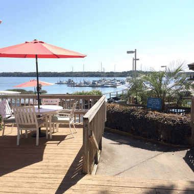
Shout out a big Welcome to SALTY SOUTHEAST CRUISERS’ NET’s newest sponsor, Homer Smith’s Docks and Marina on Town Creek in beautiful Beaufort, NC.
Ahoy Cruisers, Slip into waterfront luxury with Homer Smith Docks and Marina, where you’ll find friendly staff and the comfort of a home away from home. Dock your vessel here in our new, state-of-the-art facilities and unwind and discover the beauty of downtown Beaufort, NC and the rest of the Crystal Coast. Guests who dock with Homer Smith are just an easy walk or golf cart ride away from the history and action of the third oldest town in North Carolina, Beaufort. Enjoy the beautiful scenery, great dining and the quaint shopping on Front Street. The Staff at Homer Smith’s Docks and Marina


Comments from Cruisers (2)
Cruise as close to red markers as possible. That is where the deep water is located.
Just came through this area (unfortunately due to a delay at low tide). 4.5 draft got hung up when I turned toward the Green. Hug the Red side, and stay away from the Green. Saw a few similar draft vessels get through on the red side without issue. Floated off after 20 mins, a useful lunch break.