Slow Down & Stay Awhile in Elizabeth City – Elizabeth City
Elizabeth City sits at the southern terminus of the Dismal Swamp Canal and has the well-earned reputation of being a transient-friendly town with free dockage for 72 hours.

Elizabeth City sits at the southern terminus of the Dismal Swamp Canal and has the well-earned reputation of being a transient-friendly town with free dockage for 72 hours.
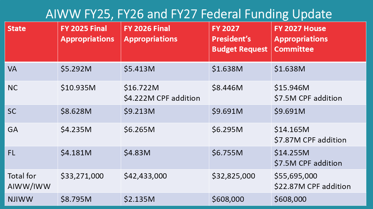
Cruisers Net is proud to be a member of the Atlantic Intracoastal Waterway Association, whose lobbying work is crucial to keeping the Waterway navigable and safe. Your membership dollars directly support their vital work. Please join and encourage your boating neighbors to do the same, regardless of their home port.
|
Cruisers’ Net Newsletter for this week has just been emailed via Constant Contact.
If you want to view the newsletter but are not signed up to receive them automatically, you can view it at https://conta.cc/4eWYtaI or see it below.
To automatically receive our emailed Fri Weekly Newsletter and Wed Fuel Report, click:

Harbour Town Yacht Basin, A CRUISERS NET SPONSOR, is ready for your reservation with newly renovated docks, upgraded electrical service and onSpot WiFi, also a CRUISERS NET SPONSOR. And, as always, numerous activities at the Sea Pines Resort are offered for your enjoyment, as you will see in the Event Schedule below. Hilton Head Island is absolutely marvelous any time of year.

Harbour Town Yacht Basin, A CRUISERS NET SPONSOR, is ready for your reservation with newly renovated docks, upgraded electrical service and onSpot WiFi, also a CRUISERS NET SPONSOR. And, as always, numerous activities at the Sea Pines Resort are offered for your enjoyment, as you will see in the Event Schedule below. Hilton Head Island is absolutely marvelous any time of year.
https://cruisersnet.net/wp-content/uploads/2026/06/August-2026-Sea-Pines-Events.pdf


Kerry Maveus
kmaveus@hunter-pr.com | www.hunter-pr.com
mobile: 831-917-2878
P.O. Box 1049 | Pebble Beach, CA | 93953

SALTY SOUTHEAST CRUISERS’ NET SPONSOR, Charleston Harbor Marina, would be a great place to dock your boat while you are visiting Charleston and to watch these fireworks. Charleston Harbor Marina sits on the Mount Pleasant side of Charleston Harbor, hard by Patriots Point between Horse Reach’s flashing buoys #34 and #36.
Good afternoon Charleston HSC,
Please find attached the MSIB 10-26 for the SC250 Fireworks Safety Zone. The event information is as follows:
Charleston SC250 will host a fireworks display on Saturday, July 4, 2026, over the Charleston Harbor, SC. A safety zone, encompassing a 1000-foot radius surrounding the fireworks barge will be enforced while the barge is in transit through the Charleston Harbor and from 7:00 p.m. on July 4, 2026, to 12:00 a.m. on July 5, 2026, while the fireworks are being launched adjacent to Waterfront Park.
During the enforcement period listed above, no person or vessel may enter, transit through, anchor in, or remain within the designated area unless authorized by the COTP Charleston or a designated representative.
Waterway users are reminded to use caution while transiting Charleston Harbor, remaining mindful of dredging operations, commercial vessel traffic, and higher than normal recreational vessel traffic during this holiday weekend.
For questions or concerns regarding this MSIB, please contact the Sector Charleston 24-hour Command Center at (833) 453-1261.
Very respectfully,
LT Nicholas Jones
WWM Division Chief
USCG Sector Charleston
Nicholas.J.Jones@uscg.mil
O: 843-740-3184
C: 843-323-7761
https://cruisersnet.net/wp-content/uploads/2026/06/MSIB-10-26_SC250-Fireworks_Safety-Zone_2026.pdf

Screenshot
Click Here To Open A Chart View Window, Zoomed To the Location of Charleston Harbor Marina
SALTY SOUTHEAST CRUISERS’ NET SPONSOR, Charleston Harbor Marina, would be a great place to dock your boat to watch the Patriots Point fireworks. Charleston Harbor Marina sits on the Mount Pleasant side of Charleston Harbor, hard by Patriots Point between Horse Reach’s flashing buoys #34 and #36.
Good afternoon Charleston HSC,
Please find attached MSIB 09-26 for the North Charleston and Patriots Point Fireworks Events. The event details are as follows:
North Charleston Fireworks – On July 4, 2026 (or a rain date of July 5), from 9:00 p.m. to 9:30 p.m. all waters within a 100-yard radius of the barge, from which fireworks will be launched on the Cooper River near River Front Park in North Charleston, South Carolina.
Patriots Point Fireworks – On July 4, 2026 (or a rain date of July 5), from 8 p.m. to 10 p.m. all waters within a 500-yard radius of the barge, from which fireworks will be launched on the Cooper River near the USS YORKTOWN in Mount Pleasant, South Carolina.
These safety zones are necessary to protect vessels, spectators, and the general public during the events. During the enforcement periods listed above, no person or vessel may enter, transit through, anchor in, or remain within the designated area unless authorized by the COTP Charleston or a designated representative.
Waterway users are reminded to use caution while transiting Charleston Harbor, remaining mindful of dredging operations, commercial vessel traffic, and higher than normal recreational vessel traffic during this extended holiday weekend.
For questions or concerns regarding this MSIB, please contact the Sector Charleston 24-hour Command Center at (833) 453-1261.
Very respectfully,
LT Nicholas Jones
WWM Division Chief
USCG Sector Charleston
Nicholas.J.Jones@uscg.mil
O: 843-740-3184
C: 843-323-7761


Screenshot
Click Here To Open A Chart View Window, Zoomed To the Location of Charleston Harbor Marina

There is always plenty to do around Charlotte Harbor. While berthed at Fishermen’s Village Marina, A CRUISERS NET SPONSOR, you are certain to enjoy visiting Western Florida’s beautiful Charlotte Harbor/Peace River.


Special Events & Community Relations
941.639.8721
Click Here To View the Western Florida Cruisers Net Marina Directory Listing For Fishermen’s Village
Click Here To Open A Chart View Window Zoomed To the Location of Fishermen’s Village
During Independence Day or anytime, be sure to stay at St. Marys Intracoastal Gateway Marina, a CRUISERS NET SPONSOR!
https://visitstmarys.com/independence-day-festival-1


Members of the RMHYS enjoy special and beautiful times together in Abaco’s. Membership is open to all. ” Give ’em a shout. You will be glad you did. If you are cruising the Bahamas this winter, consider joining Royal Marsh Harbour Yacht Club, a premier yacht club in the Abacos and A CRUISERS NET SPONSOR!
|

Staniel Cay Yacht Club, A CRUISERS NET SPONSOR, looks forward to seeing you all as you visit the Bahamas!
Elizabeth City sits at the southern terminus of the Dismal Swamp Canal and has the well-earned reputation of being a transient-friendly town with free dockage for 72 hours.
| |||||||||||||||||||||||||||||||||||||||||||||||||||||||||||||||||||||||||||||||||||||||||||||||||||||||||||||||||||||||||||||||||||||||||||||||||||||||||||||||||||||||||||||||||||||||||||||||||||||||||||||||||||||||||||||||||||||||||||||||||||||||||||||||||||||||||||||||||||||||||||||||||||||||||||||||||||||||||||||||||||||||||||||||||||||||||||||||||||||||||||||||||||||||||||||||||||||||||||||||||||||||||||||||||||||||||||||||||||||||||||||||||||||||||||||||||||||


 June 30


Be the first to comment!